Virtual geographical environment (VGE) symbolic model and map symbol sharing system and method based on same

A technology of map symbols and symbol models, applied in the direction of drawing from basic elements, special data processing applications, instruments, etc., can solve the problems that have not been widely recognized, cannot fundamentally solve the problems of map symbol sharing, single primitive types, etc.

Inactive Publication Date: 2010-07-28
NANJING NORMAL UNIVERSITY
View PDF0 Cites 13 Cited by
  • Summary
  • Abstract
  • Description
  • Claims
  • Application Information

AI Technical Summary

Problems solved by technology

In order to realize the sharing of map symbols, people have tried various methods such as TrueType fonts and symbol correspondence tables. However, due to differences in the data structure and composition of map symbols in different systems, these methods cannot fundamentally solve the problem of map symbols. shared question
The Styled Layer Descriptor (SLD) specification formulated by OGC attempts to unify the data structure of map symbols. However, the "SLD" primitive type is single and has not been widely recognized.

Method used


Image

  • Virtual geographical environment (VGE) symbolic model and map symbol sharing system and method based on same
  • Virtual geographical environment (VGE) symbolic model and map symbol sharing system and method based on same
  • Virtual geographical environment (VGE) symbolic model and map symbol sharing system and method based on same

Examples


Embodiment 1

[0029] The VGE symbol model provided by the present invention is composed of map symbol data model and map symbol rendering. in:

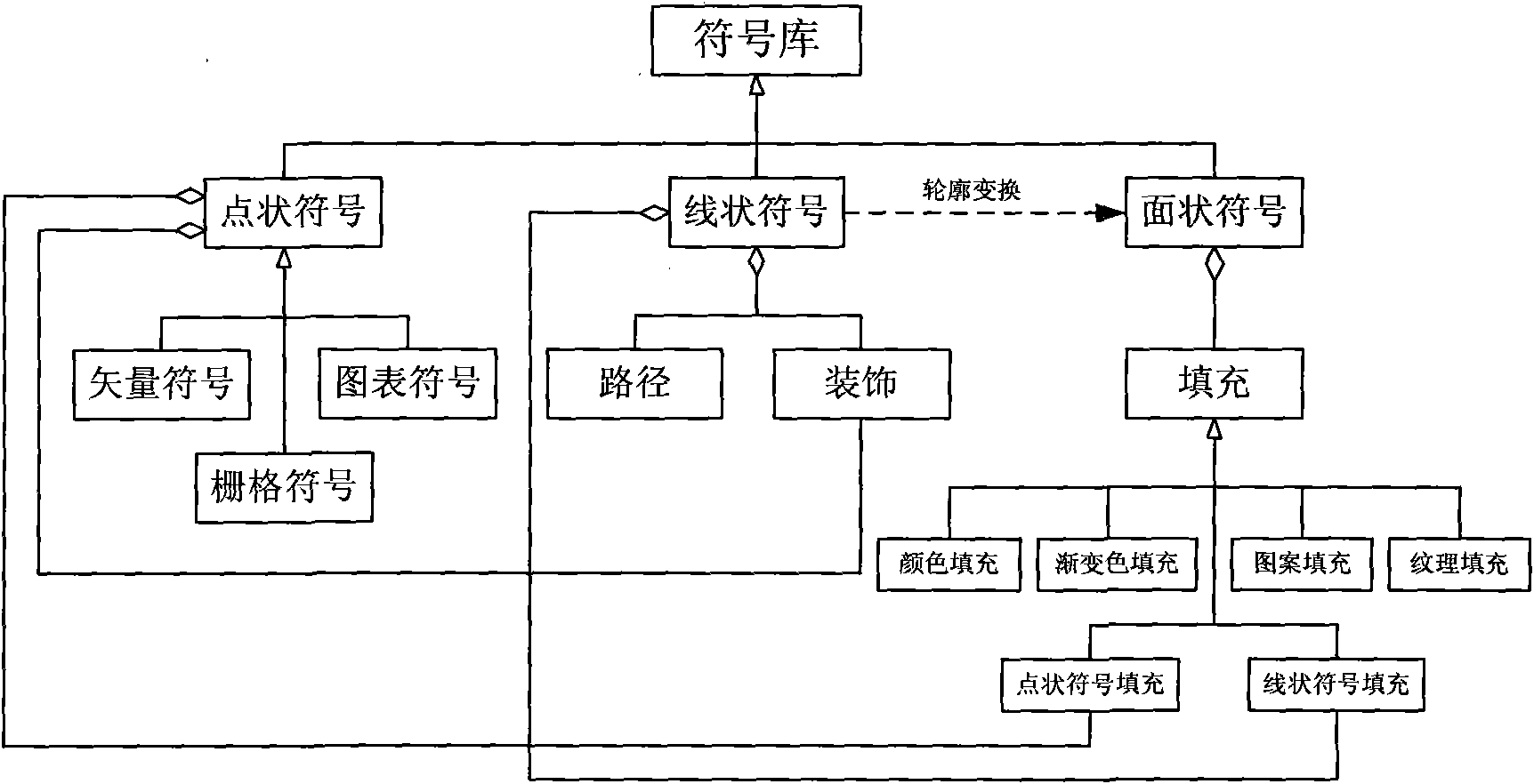
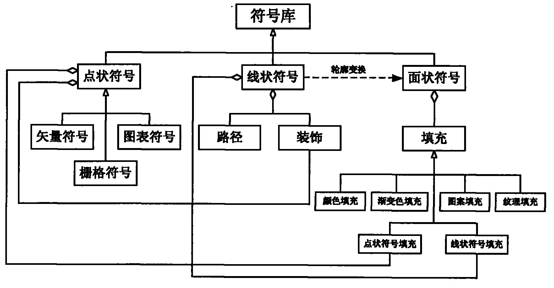
[0030] Such as figure 1 As shown in , the map symbol data model is composed of point symbols, line symbols, area symbols, etc. Point symbols include vector point symbols, grid point symbols and chart point symbols; line symbols are composed of strokes and line decorations; area symbols are composed of fills, which can be divided into color fills, gradient fills, patterns Six filling modes including filling, point symbol filling, line symbol filling, and texture filling; line symbols can perform affine transformation on the outline through the interface, and transform line symbols into area symbols.

[0031] The map symbol renderer consists of three interfaces: stroke processor, fill processor and path transformation. Rendering is associated with the canvas, and the canvas can be associated with the device environment handle and the raster image,...

Embodiment 2

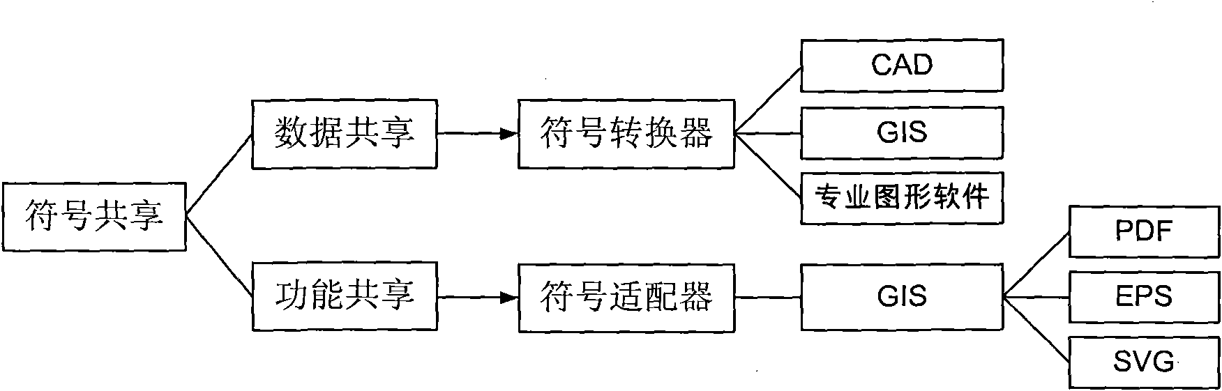
[0033] Such as figure 2 As shown, the map symbol sharing system based on VGE symbol model, the system is composed of VGE symbol model, map symbol designer, map symbol adapter and map symbol converter; among them,

[0034] The VGE symbol model consists of a map symbol data model and a map symbol renderer;

[0035] Map symbol designer, used to design map symbols, professional field symbols and generalized graphic symbols based on the VGE symbol model;

[0036] The map symbol converter is used to read symbols or graphic files of CAD, GIS, and professional graphics software on the basis of the VGE symbol model, and convert them into map symbols in a unified format (VGE symbols);

[0037] The map symbol adapter is used to apply the map symbol renderer to the GIS-related software platform through secondary development or API.

Embodiment 3

[0039] The invention also provides a map symbol sharing method based on the VGE symbol model, which includes a map symbol designer, a map symbol converter and a map symbol adapter.

[0040] Such as figure 2 As shown, the map symbol sharing method based on the VGE symbol model, the method adopts the following steps:

[0041] Step 1. Use the VGE map symbol designer to make map symbols. The symbol designer is based on the VGE symbol model, so it can make almost all symbols and generate symbol files.

[0042] Step 2. For the existing symbol files in other formats (such as *.dxf, *.style), use the map symbol converter to directly import the symbols in CAD, GIS and professional graphics software into the VGE symbol library. Because the non-uniform rational B-spline curve is added to the VGE map symbol data model, this curve is the only representation method for free-form curves in the STEP standard and a unified expression method for all graphics, so it can be used in CAD, GIS and...


PUM


Abstract

The invention discloses a VGE symbolic model and map symbol sharing system and method based on the same, wherein the VGE symbolic model comprises a map symbol data model and a map symbol rendering model. The invention also provides the map symbol sharing system based on the model, which is divided into data sharing and function sharing and comprises the VGE symbolic model, a map symbol designer, a map symbol switcher and a map symbol adapter. The invention has the advantages that map symbol data and map symbol rendering are separated so that symbols made by current computer aided design (CAD), geographic information system (GIS) and professional figure software can be assimilated; and due to the adoption of a professional figure rendering engine, the high-quality output and the multi-channel output of maps can be realized through grafting the engine in a plurality of GIS platforms. Therefore, the invention realizes the symbol sharing among the GIS, the CAD and the professional figure software and provides an approach for the multifunction of a map symbol library and the 'what you see is what you get' of map symbols.

Description

technical field [0001] The invention relates to the fields of geographic information system (GIS), computer aided design (CAD), computerized cartography (CAC), navigation map, mobile phone map, electronic map, etc., and particularly relates to a map symbol sharing system and sharing method. Background technique [0002] Map symbols are the graphical language of maps and the basic means of expressing map content, used to communicate the objective world, mapmakers and map users. It stimulates the left brain of people through pictographic and knowing graphics to generate mental images to convey information such as the characteristics and distribution rules of geographical entities. Map symbol design and map symbol library are one of the key technologies of Geographic Information System (GIS), cartography and various electronic map software. GIS and CAD are two different platforms. The former emphasizes data management and spatial analysis, centered on geographic objects, while...

Claims


Application Information

Patent Timeline
Patent Type & Authority Applications(China)
IPC IPC(8): G06F17/30G06T11/20
Inventor 闾国年盛业华吴明光温永宁陈泰生
Owner NANJING NORMAL UNIVERSITY
Why Eureka
Try Eureka