

Quick parallelization programming template method for remote sensing image processing algorithm
A remote sensing image processing and remote sensing image technology, applied in program control devices, radio wave measurement systems, instruments, etc., to achieve the effects of high parallel efficiency, rapid parallelization, and improved processing performance
- Summary
- Abstract
- Description
- Claims
- Application Information
AI Technical Summary
Problems solved by technology
Method used
Image

Examples
Embodiment Construction
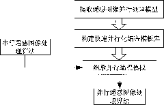
[0024] Such as Figure 1-8 As shown, a kind of fast parallel programming template method for remote sensing image processing algorithm described in the embodiment of the present invention comprises the following steps:
[0025] 1) Extract three typical remote sensing image parallel processing models:
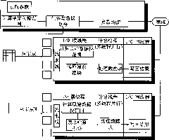
[0026] According to the repetitive calculation characteristics of the algorithm, it can be classified into three categories: pixel repeated operation, local area repeated operation, inter-band repeated operation and global information type operation, and three typical parallel computing models are extracted, including pure data parallel model, band Relational data parallel model, global information computing parallel model.
[0027] Pure Data Parallel Model: It is mainly aimed at algorithms with repetitive calculations in local areas. The output image can be obtained by independent calculation of a certain pixel in the input image or pixels in a local area. It is suitable for i...
PUM
 Abstract
Description
Claims
Application Information