Wireless sensor network node positioning method based on distance assistance

A wireless sensor network and node positioning technology, which is applied in wireless communication, network topology, electrical components, etc., can solve the problems of large positioning errors, achieve the effects of reducing physical position differences, improving positioning accuracy, and improving positioning accuracy

Inactive Publication Date: 2010-09-15
HARBIN INST OF TECH
View PDF4 Cites 29 Cited by
  • Summary
  • Abstract
  • Description
  • Claims
  • Application Information

AI Technical Summary

Problems solved by technology

[0006] In order to solve the problem of large positioning errors in existing wireless sensor network positioning...

Method used


Image

  • Wireless sensor network node positioning method based on distance assistance
  • Wireless sensor network node positioning method based on distance assistance
  • Wireless sensor network node positioning method based on distance assistance

Examples


specific Embodiment approach 1

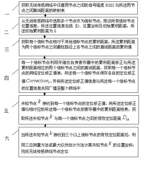
[0018] Specific implementation mode one: according to the instructions attached figure 1 , 2 , 3 and 4 specifically illustrate this embodiment, a distance-assisted wireless sensor network node positioning method described in this embodiment, the wireless sensor network includes a plurality of unknown nodes and a plurality of beacon nodes, the The positioning method includes the following steps:

[0019] Step 1: Obtain a mapping table of the signal strength RSSI between any two nodes in the wireless sensor network and the linear distance between the two nodes;

[0020] Step 2: select a plurality of nodes from the wireless sensor network as beacon nodes, and preset the position information of all beacon nodes, the position information includes ID, position coordinates and initial cumulative distance, and the initial cumulative distance is 0;

[0021] Step 3: Obtain the cumulative distance of each beacon node relative to other beacon nodes, where the cumulative distance is the ...

specific Embodiment approach 2

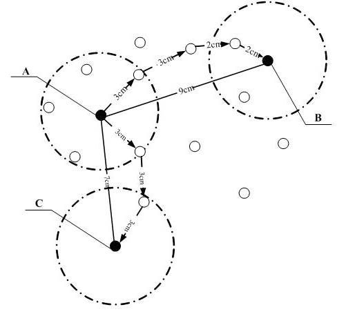
[0034] Specific embodiment 2: This embodiment is a further description of specific embodiment 1. Specific embodiment 1 In step 3, in the process of obtaining the cumulative distance of each beacon node relative to other beacon nodes, a beacon is obtained The method for accumulating the distance of a node relative to another beacon node is:

[0035]Step 31: A beacon node broadcasts the location information of the beacon node, and after each node within the communication radius of the beacon node receives the location information broadcast by the beacon node, it receives the Each node of the position information obtains the linear distance between the beacon node and the node, and corresponds the position coordinates of the beacon node to the linear distance by identifying the ID of the beacon node;

[0036] Step 32: Each node within the communication radius of the beacon node serves as the upper-level node to send measurement information to the lower-level node, and the lower-l...

specific Embodiment approach 3

[0041] Embodiment 3: This embodiment is a further description of Embodiment 2. In Embodiment 2, in step 31, each node that receives the location information obtains the distance between the beacon node and the node. The method for the straight-line distance between them is: each node within the communication radius of the beacon node queries the mapping table according to the received signal strength RSSI from the beacon node to obtain the straight-line distance, and the straight-line distance is is the straight-line distance between the beacon node and the node.

[0042] In this embodiment, the beacon node broadcasts the beacon node information to other nodes by using a typical distance vector routing exchange protocol.

[0043] In this embodiment, not only all beacon nodes can obtain the cumulative distance path information between the beacon nodes, but also all unknown nodes can also obtain the cumulative distance value from the beacon nodes.


PUM


Abstract

The invention relates to a wireless sensor network node positioning method based on distance assistance, relating to the technology of wireless sensor network positioning and solving the problem of great error of positioning of traditional wireless sensor network positioning methods. The wireless sensor network node positioning method comprises the following steps of: firstly establishing a mapping table relative to signal strength and distance, then receiving the signal strength of beaconing nodes, and querying the mapping table according to the signal strength of the beaconing nodes to further obtain the cumulative distance of other nodes; calculating the positioning correction value of the beaconing nodes, and further obtaining the effective positioning distance between an unknown nodeand the beaconing node; and finally utilizing a trilateration method or a maximum likelihood estimation method to calculate the position coordinates of the unknown node to complete wireless sensor network node positioning. The invention is suitable for wireless sensor network positioning.

Description

technical field [0001] The invention relates to the technical field of wireless sensor network positioning, in particular to a distance-assisted wireless sensor network node positioning method. Background technique [0002] The wireless sensor network is composed of a large number of micro sensor nodes deployed in the monitoring area, and forms a multi-hop self-organizing network through wireless communication. played an important role. American Business Weekly and MIT Technology Review listed wireless sensor network as one of the 21 most influential technologies in the 21st century and one of the top ten technologies that changed the world in their reports predicting future technological development. In many application fields of sensors, location information plays a very important role. In applications such as emergency handling, disaster awareness, and military tactical communication networks, location management is an extremely important issue. Perception information m...

Claims


Application Information

Patent Timeline
IPC IPC(8): H04W64/00H04W84/18
Inventor 姜琰俊石硕顾学迈郭庆杨明川吴宣利贾敏韩帅林佩
Owner HARBIN INST OF TECH
Why Eureka
Try Eureka