High-resolution imaging method for earth synchronous orbit synthetic aperture radar satellite

A technology of synthetic aperture radar and geosynchronous orbit, which is applied in the field of signal processing to achieve the effect of liberalization of the imaging area

Inactive Publication Date: 2010-12-15
BEIHANG UNIV
View PDF5 Cites 44 Cited by
  • Summary
  • Abstract
  • Description
  • Claims
  • Application Information

AI Technical Summary

Problems solved by technology

So far, no scholars at home and abroad have proposed a high-resolution imaging method for GEO SAR full-aperture data processing

Method used


Image

  • High-resolution imaging method for earth synchronous orbit synthetic aperture radar satellite
  • High-resolution imaging method for earth synchronous orbit synthetic aperture radar satellite
  • High-resolution imaging method for earth synchronous orbit synthetic aperture radar satellite

Examples


Embodiment

[0084] The satellite orbit parameters, satellite attitude parameters and radar parameters are shown in Table 1, Table 2 and Table 3.

[0085] Table 1 Satellite orbit parameters

[0086]

[0087] Table 2 Satellite attitude parameters

[0088]

[0089] Table 3 Radar parameters

[0090]

[0091]

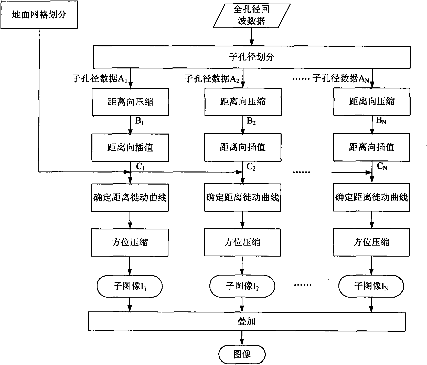
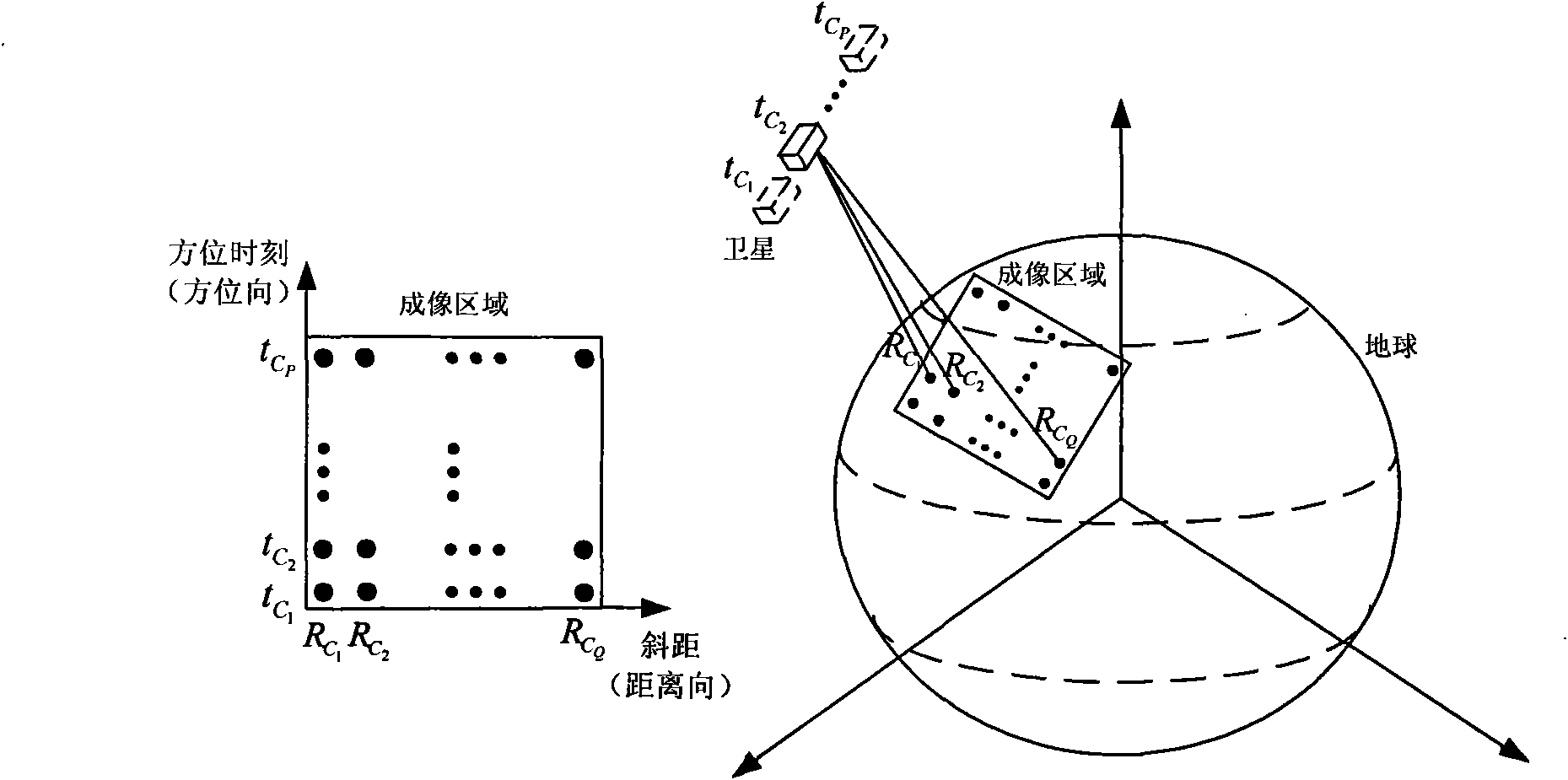
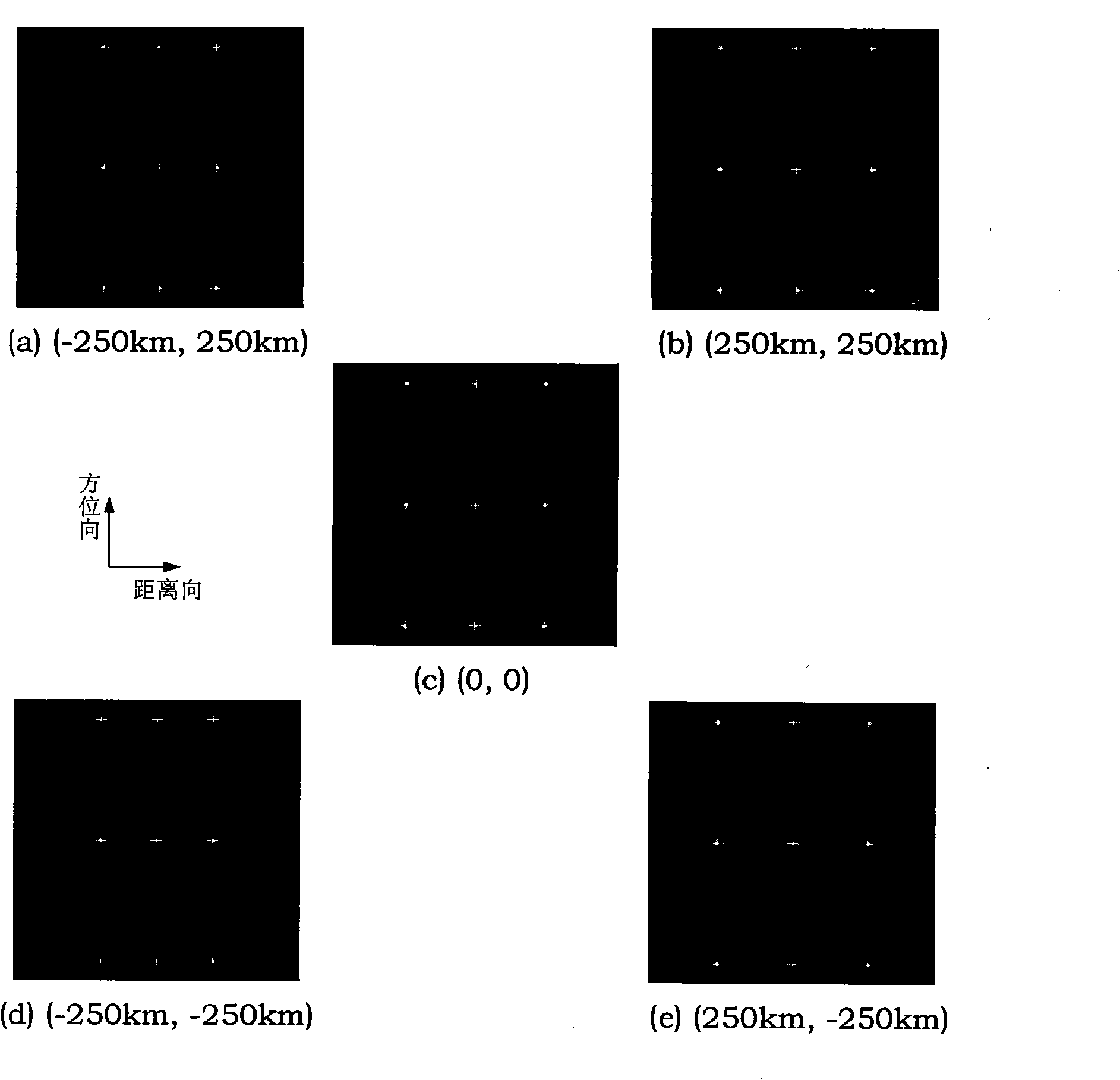
[0092] According to the parameters in Table 1 to Table 3, the echo simulation of the 3×3 lattice targets in five scenes within the range of 500km×500km on the ground near the equator was carried out, and five full-aperture echo data were obtained. Using Tables 1 to 3 The parameters in Table 3 are used for imaging processing for each data according to the following steps.

[0093] Step 1: sub-aperture division;

[0094] The data size of a full aperture echo in the simulation is 450000×4096, with 450000 points in azimuth and 4096 points in distance (2 12 ) points, the data volume is 13.733GB. Using a computer equipped with windows xp operating system (32-bit system) to pr...


PUM


Abstract

The invention discloses a high-resolution imaging method for an earth synchronous orbit synthetic aperture radar satellite. The method comprises the following steps of: 1, dividing a sub-aperture; 2, performing range compression on the sub-aperture data; 3, performing range interpolation on the sub-aperture data; 4, dividing a ground grid; 5, determining a range migration curve; 6, performing azimuth compression processing; and 7, superposing sub-aperture images to obtain the final image. By the imaging method provided by the invention, high-resolution imaging can be realized by processing the full-aperture echo data of the earth synchronous orbit synthetic aperture radar satellite, multi-point target imaging can be realized, namely azimuth compression can be performed on different range migration curves of different range and azimuth targets, and imaging in a wide-area scene range can be realized and the method has the characteristic of free imaging area, namely imaging can be performed on scenes at different positions as required.

Description

technical field [0001] The invention relates to a high-resolution imaging method for a geosynchronous orbit (GEO) synthetic aperture radar (SAR) satellite, and belongs to the technical field of signal processing. Background technique [0002] Spaceborne synthetic aperture radar has all-weather and all-weather working capabilities, and it is an earth observation system that has attracted much attention at present. In remote sensing applications, repeated observation cycle is a very important technical indicator. Fields such as terrain dynamic monitoring and understanding of surface phenomena require continuous observation or frequent revisiting. Experiments show that for soil moisture detection, the observation system with 1-day revisit time can obtain 55% valid information, while the system with 35-day revisit time can only obtain 20% valid information. However, the existing SAR satellites are all operating in low orbits and have a long repetition period, which makes it di...

Claims


Application Information

Patent Timeline
Patent Type & Authority Applications(China)
IPC IPC(8): G01S13/90
Inventor 李卓于泽李春升陈杰
Owner BEIHANG UNIV
Why Eureka
Try Eureka