Position and speed combined estimation method for satellite navigation

A technology of joint estimation and speed estimation, applied in satellite radio beacon positioning systems, measuring devices, instruments, etc., can solve the problems that cannot be applied to the application environment with high requirements for speed measurement accuracy

Active Publication Date: 2011-04-27
ZHEJIANG UNIV
View PDF5 Cites 22 Cited by
  • Summary
  • Abstract
  • Description
  • Claims
  • Application Information

AI Technical Summary

Problems solved by technology

When the position estimation deviation is less than 20m, the speed estimation deviation is about 1m/s to

Method used


Image

  • Position and speed combined estimation method for satellite navigation
  • Position and speed combined estimation method for satellite navigation
  • Position and speed combined estimation method for satellite navigation

Examples


Embodiment

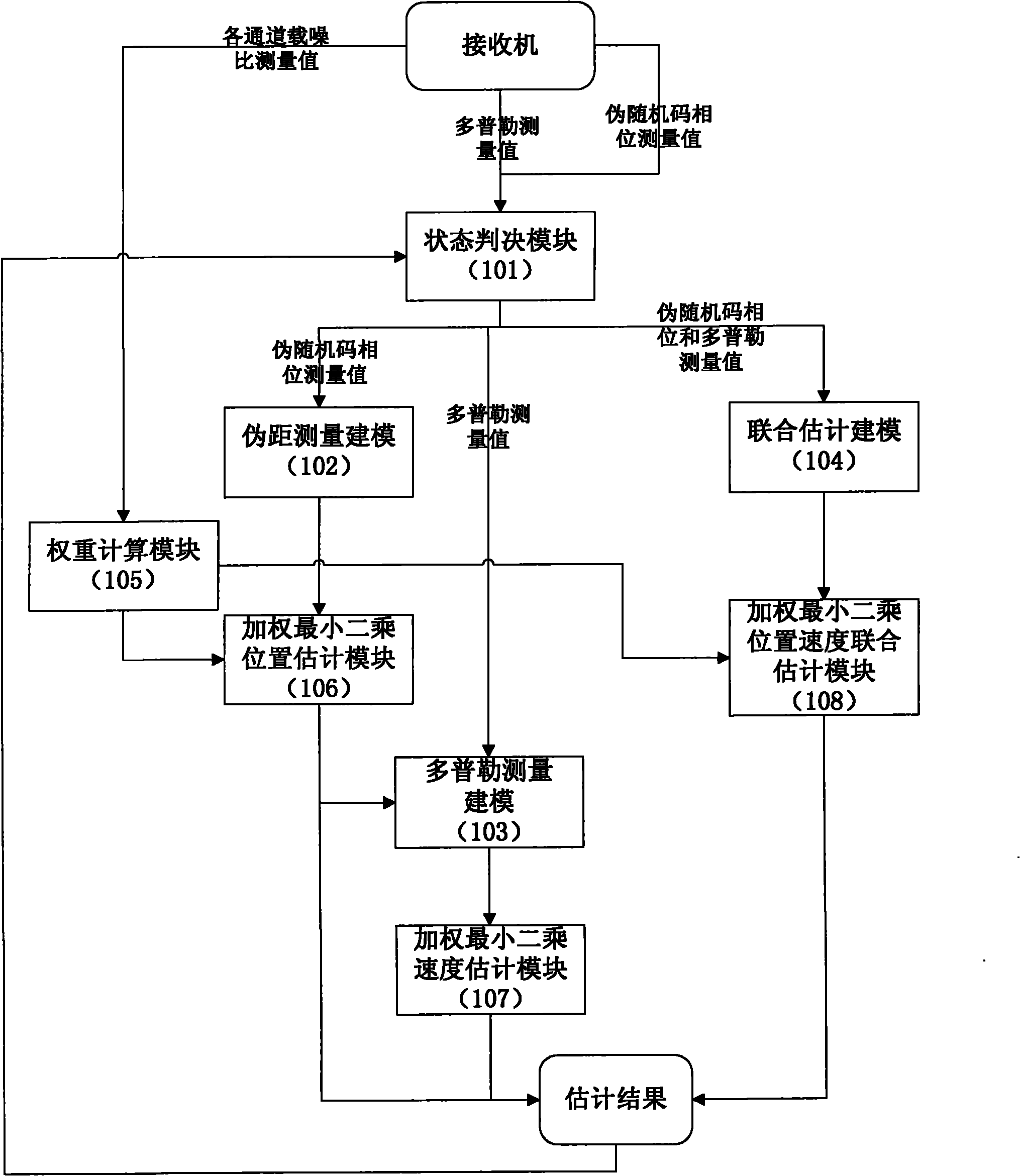
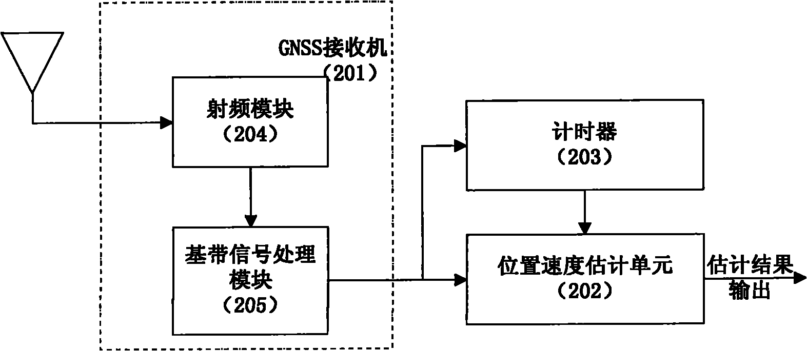
[0087] The invention provides a joint estimation method of satellite navigation position and velocity. Embodiment structural block diagram such as figure 2 As shown, it includes three parts: GNSS receiver 201 , position and velocity estimation unit 202 and timer 203 . Wherein, the GNSS receiver includes two parts: a radio frequency module 204 and a baseband signal processing module 205 . The GNSS satellite signal is sent to the input terminal of the radio frequency module 204 through the antenna, and the signal is converted into an analog intermediate frequency signal after being down-converted by the module. The analog intermediate frequency signal output by the radio frequency module 204 is sampled by the AD according to the 48MHz clock to form a digital intermediate frequency signal, which is input to the baseband signal processing module 205 . The baseband signal processing module 205 is realized by FPGA, and completes the work of GNSS satellite signal acquisition, trac...


PUM


Abstract

The invention discloses a position and speed combined estimation method for satellite navigation, which solves the problem of real-time estimation of the position and speed of a receiver when an accurate carrier phase measured value cannot be acquired by modeling a recurrent Doppler measured value of the receiver and performing coupled solution with a pseudo-range measurement model based on the correlation between the Doppler measured value and the position of the receiver. The method comprises the following steps of: performing combined estimation on positioning and speed measurement at each new epoch moment according to the current pseudo-range measured value and Doppler measured value; and weighting least square based on a nonlinear equation system to solve an estimated position in an iterative process to replace a pseudo-range positioning result to serve as a reference position for the speed estimation of the receiver, so that the speed estimated value is gradually converged along with the position estimation. Meanwhile, estimation error comprises speed error to ensure that the algorithm convergence judgment is stricter, and the search step of an algorithm around the actual position is reduced so as to acquire higher estimation accuracy. By the method, real-time positioning and speed measurement can be reliably realized, and the method is suitable for various satellite navigation systems such as a global positioning system (GPS), a global orbit navigation satellite system (GLONASS) and the like.

Description

technical field [0001] The invention relates to a joint estimation method of satellite navigation position and velocity. Background technique [0002] With the wide application of satellite navigation technology in aerospace, aviation, remote sensing, communication, surveying and mapping and other fields, the global satellite navigation system has rapidly penetrated into various fields of your life, greatly improving the efficiency of the sound field. The GNSS system is a global, all-time, all-weather navigation, positioning, timing, and speed measurement system. In recent years, with the popularity of personal applications, the market's requirements for GNSS positioning, speed measurement performance and stability have risen rapidly. [0003] Satellite navigation and positioning methods mainly include carrier phase positioning and pseudo-range positioning. Carrier phase positioning utilizes the accuracy of the real-time phase of satellite signals to obtain centimeter-leve...

Claims


Application Information

Patent Timeline
IPC IPC(8): G01S19/42G01S19/52G01S19/27
Inventor 李立言赵民建钟杰王悦
Owner ZHEJIANG UNIV
Why Eureka
Try Eureka