Method for converting topographic map data format to overhead line format

An overhead line, topographic map technology, applied in electrical digital data processing, special data processing applications, instruments, etc., can solve problems such as error-prone, unable to meet the construction period, time-consuming and labor-intensive, etc.

Active Publication Date: 2013-04-24
内蒙古电力勘测设计院有限责任公司
View PDF3 Cites 0 Cited by
  • Summary
  • Abstract
  • Description
  • Claims
  • Application Information

AI Technical Summary

Problems solved by technology

[0005] These conventional methods are cumbersome, time-consuming, and labor-intensive, and are prone to errors. If the overhead power transmission line is short, fortunately, if the overhead power transmission line is long, sometimes it cannot meet the requirements of the construction period.

Method used


Image

  • Method for converting topographic map data format to overhead line format
  • Method for converting topographic map data format to overhead line format
  • Method for converting topographic map data format to overhead line format

Examples


Embodiment Construction

[0023] Open the vectorized large-scale topographic map with the commonly used measurement software Southern CASS Mapping System, design the direction of the overhead power transmission line on the vectorized large-scale topographic map, and use the mileage file generated in the survey software Southern CASS Mapping System, generated as figure 1 format shown.

[0024] The purpose of the present invention is to figure 1 The format file shown is converted into a standard SLCAD overhead power transmission line section view processing and positioning CAD system data ORG format file, the format of the file is as follows figure 2 shown.

[0025] The above two formats are only exemplary, and are not intended to limit the protection scope of the present invention. Using the method of the present invention, data conversion in other related formats can also be realized.

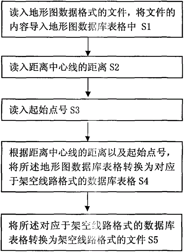
[0026] The present invention adopts database technology to realize the conversion of data format, generates the...


PUM


Abstract

The invention provides a method for converting a topographic map data format to an overhead line format and belongs to the technical field of design tower emptying of a power line. The method comprises the following steps of: 1, reading a file of the topographic map data format, and importing contents of the file into a topographic map database table; 2, reading distance of a distance center line; 3, reading a starting point number; 4, converting the topographic map database table to a database table which corresponds to the file of the overhead line format according to the distance of the distance center line and the starting point number; and 5, converting the database table which corresponds to the overhead line format to the file of the overhead line format. By the method, the technical problems of complicated process, time consumption, labor consumption, high error rate and the like of the conventional conversion method are solved.

Description

technical field [0001] The invention belongs to the technical field of power line design and arranging towers, and in particular relates to a method for converting a topographic map data format into an overhead line format. Background technique [0002] With the development of science and technology in our country and the needs of engineering technology, there are more and more large-scale topographic maps. We can skillfully use the existing vectorized large-scale topographic maps to provide high-quality and fast services for our engineering construction. Vectorized Large Scale Terrain Figure 1 Generally, they are saved in DWG and DXF formats of AutoCAD, and can be opened by the commonly used measurement software Southern CASS Mapping System. In fact, the Southern CASS Mapping System can also generate cross-sectional drawings, but it can only generate its own format in AutoCAD and cannot be used for Design row towers for power lines. [0003] Therefore, according to the co...

Claims


Application Information

Patent Timeline
Patent Type & Authority Patents(China)
IPC IPC(8): G06F17/30G06F17/50
Inventor 孟现彪刘永强冯禹张风安毛克
Owner 内蒙古电力勘测设计院有限责任公司
Why Eureka
Try Eureka