A frequency-domain coherent joint acquisition method for GNSS data/pilot mixed signals

A mixed-signal, coherent joint technology, applied in satellite radio beacon positioning systems, measurement devices, instruments, etc., can solve the problems of not making full use of the new system navigation signals and low acquisition performance.

Inactive Publication Date: 2011-12-14
HARBIN INST OF TECH
View PDF3 Cites 13 Cited by
  • Summary
  • Abstract
  • Description
  • Claims
  • Application Information

AI Technical Summary

Problems solved by technology

[0005] The present invention aims to solve the problem that the traditional single-channel acquisition method cannot make full use of the energy of the new system n

Method used


Image

  • A frequency-domain coherent joint acquisition method for GNSS data/pilot mixed signals
  • A frequency-domain coherent joint acquisition method for GNSS data/pilot mixed signals
  • A frequency-domain coherent joint acquisition method for GNSS data/pilot mixed signals

Examples


specific Embodiment approach 1

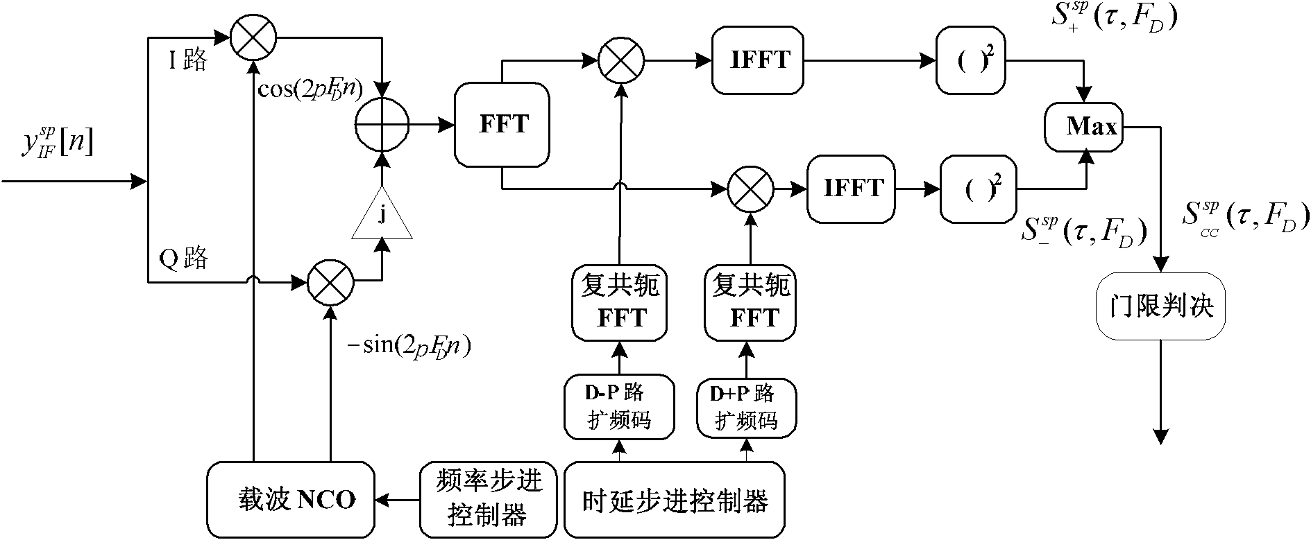
[0040] Specific implementation mode 1. Combination figure 1 with figure 2 Describe this specific embodiment, a frequency domain coherent joint acquisition method of GNSS data / pilot mixed signal,

[0041] The GNSS satellite signal transmitted by the transmitter is an in-phase data / pilot mixed signal, and the in-phase data / pilot mixed signal C sp [n] expression is:

[0042] C sp [ n ] = C D [ n ] - C P [ n ] d [ n ] = 1 ...

specific Embodiment approach 2

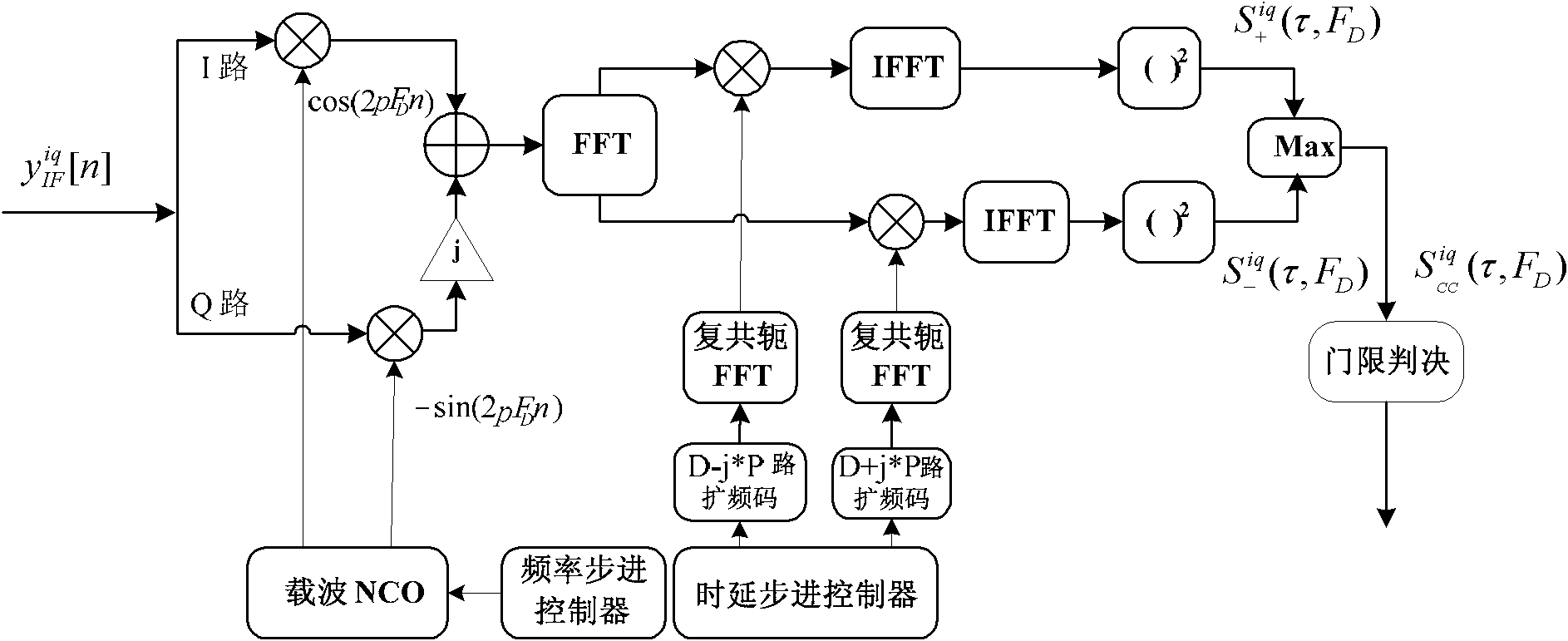
[0057] Specific embodiment two, combine figure 2 Describe this specific embodiment, a frequency domain coherent joint acquisition method of GNSS data / pilot mixed signal,

[0058] The GNSS satellite signal transmitted by the transmitter is an orthogonal data / pilot mixed signal, and the orthogonal data / pilot mixed signal is:

[0059] C iq [ n ] = C D [ n ] - j C P [ n ] d [ n ] = 1 ...


PUM


Abstract

The invention relates to a frequency domain coherent joint capture method of a GNSS data/pilot mixed signal, more particularly to a coherent joint capture method of a GNSS data/pilot mixed signal. According to a traditional single-channel capture method, energies of a new-system navigation signal can not fully utilized, so that capture performance is poor; however, the above-mentioned problem canbe solved according to the invention. The method comprises the following steps that: with utilization of a phase relationship between a data channel signal and a pilot channel signal, coherent processing is carried out on the signals of the two channels aiming at a GNSS data/pilot mixed signal, and then capture is completed. The invention is suitable for application in a capture process of a GNSSdata/pilot mixed signal.

Description

technical field [0001] The invention relates to a method for coherent joint acquisition of GNSS data / pilot mixed signals. Background technique [0002] Modern GNSS (Global Navigation Satellite System) adopts many advanced technologies in the design of navigation signals, which greatly improves the positioning accuracy and anti-interference ability of the system. Among them, the use of data / pilot mixed signal is a big innovation. According to the basic principle of satellite positioning, the user receiver needs to extract the pseudorange and navigation message from the navigation signal, calculate the distance between the user and the satellite and the position of the satellite, and then calculate the final user position. The traditional GPS L1C / A code signal transmits two kinds of information on one signal at the same time, so the user receiver can only obtain all information through this signal. However, when the system provides navigation and positioning services for use...

Claims


Application Information

Patent Timeline
IPC IPC(8): G01S19/29G01S19/30
Inventor 孟维晓万青韩帅邹德岳
Owner HARBIN INST OF TECH
Why Eureka
Try Eureka