Vectorization method for raster data of remote sensing images

A technology of remote sensing images and raster data, applied in the field of remote sensing image processing, can solve the problems of time-consuming and complex processing, and achieve the effect of improving the speed

Active Publication Date: 2012-01-11
BEIJING AEROSPACE HONGTU INFORMATION TECH
View PDF1 Cites 13 Cited by
  • Summary
  • Abstract
  • Description
  • Claims
  • Application Information

AI Technical Summary

Problems solved by technology

[0004] The purpose of the present invention is to propose a vectorization method for remote sensing image raster data in view

Method used


Image

  • Vectorization method for raster data of remote sensing images
  • Vectorization method for raster data of remote sensing images
  • Vectorization method for raster data of remote sensing images

Examples


Embodiment Construction

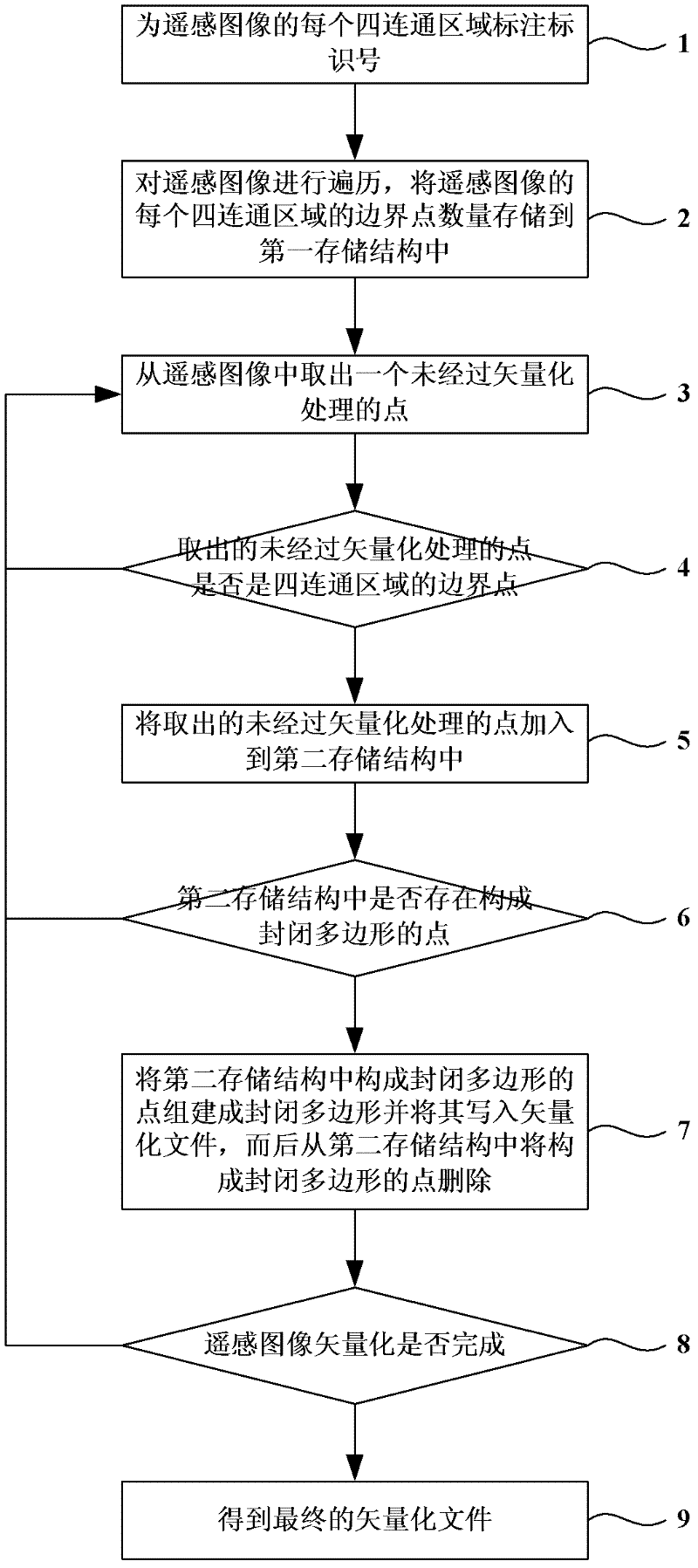
[0024] The preferred embodiments will be described in detail below in conjunction with the accompanying drawings. It should be emphasized that the following description is only exemplary and not intended to limit the scope of the invention and its application.

[0025] figure 1 is the flow chart of the vectorization method for remote sensing image raster data, figure 1 In , the vectorization method of remote sensing image raster data includes the following steps:

[0026] Step 1: Label each four-connected region of the remote sensing image with an identification number.

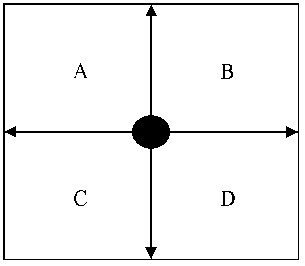
[0027] figure 2 is a schematic diagram of points processed by vectorization in the present invention. The boundary points to be extracted for the vectorization of remote sensing images do not correspond to the pixels in the image, but the points between four pixels. figure 2 The solid black circle in is the point to be processed, and the surrounding four hollow rectangles marked with A, B, C, and D are...


PUM


Abstract

The invention discloses a vectorization method for raster data of remote sensing images in the technical field of remote sensing image processing. The method includes the following steps: marking an identification number for each quad-connected region of a remote sensing image; storing the number of the boundary points of each quad-connected region of the remote sensing image into a first memory structure; extracting one unvectorized point, and if the point is not a boundary point, then adding the point into a second memory structure; when points formed into a closed polygon exist in the second memory structure, building the closed polygon with the points formed into the closed polygon and writing the closed polygon into a vectorized file, and then deleting the points formed into the closed polygon from the second memory structure; and finishing the vectorization of the remote sensing image, so that a final vectorized file can be obtained. The vectorization method overcomes the defects of the conventional remote sensing image vectorization method, and can quickly carry out the vectorization of a large-scale remote sensing image with complex polygons.

Description

technical field [0001] The invention belongs to the technical field of remote sensing image processing, in particular to a vectorization method of remote sensing image raster data. Background technique [0002] Remote sensing data is a very important data source of geographic information system. With the development of geographic information system, the dependence on remote sensing information is getting stronger and stronger. At present, a large number of analyzes and applications of GIS systems are based on vector data, and the results of some raster data analysis by remote sensing image processing systems sometimes need to be expressed in vector form. Therefore, the conversion between raster data and vector data is inevitable. Remote sensing image vectorization has also become one of the key technologies for the integration of remote sensing and geographic information systems. [0003] In the current remote sensing image vectorization method, the most commonly used frame...

Claims


Application Information

Patent Timeline
IPC IPC(8): G06T9/00
Inventor 荣岳成殷崎栋傅南翔
Owner BEIJING AEROSPACE HONGTU INFORMATION TECH
Why Eureka
Try Eureka