RSSI (Receive Signal Strength Indicator) similarity-based underground linear wireless sensor network dynamic alpha positioning method

A wireless sensor and positioning method technology, applied in wireless communication, electrical components, etc., can solve the problems of large positioning errors, achieve accurate distance measurement, low hardware requirements, and overcome non-line-of-sight errors

Inactive Publication Date: 2012-01-18
SHENYANG AEROSPACE UNIVERSITY
View PDF5 Cites 13 Cited by
  • Summary
  • Abstract
  • Description
  • Claims
  • Application Information

AI Technical Summary

Problems solved by technology

[0011] In order to solve the problem of obtaining the path loss index everywhere in the coal mine and simply using the RSSI value to reflect the similarity of the environment between the wireless sensor nodes, the problem of large positioning errors is provided by the present invention. Dynamic α localization method for linear wireless sensor networks

Method used


Image

  • RSSI (Receive Signal Strength Indicator) similarity-based underground linear wireless sensor network dynamic alpha positioning method
  • RSSI (Receive Signal Strength Indicator) similarity-based underground linear wireless sensor network dynamic alpha positioning method
  • RSSI (Receive Signal Strength Indicator) similarity-based underground linear wireless sensor network dynamic alpha positioning method

Examples


Embodiment Construction

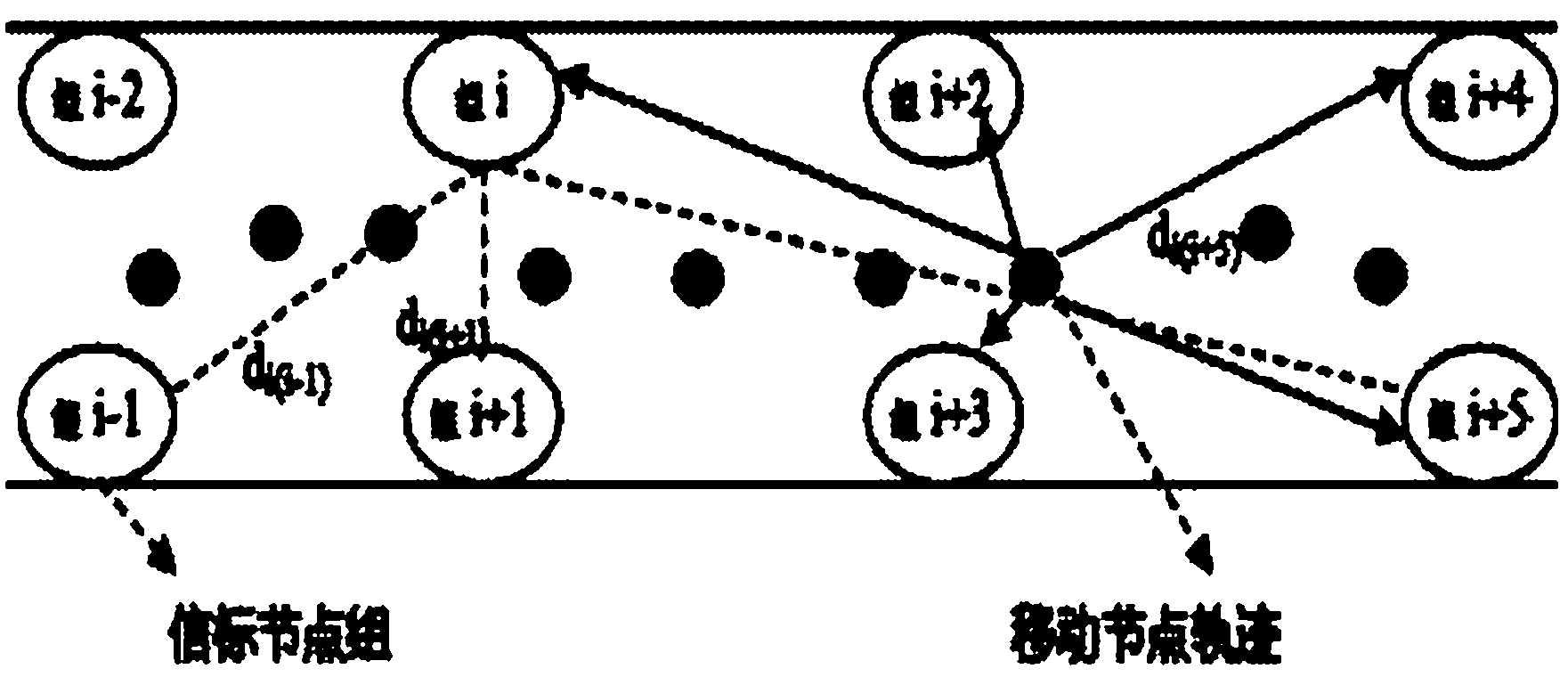
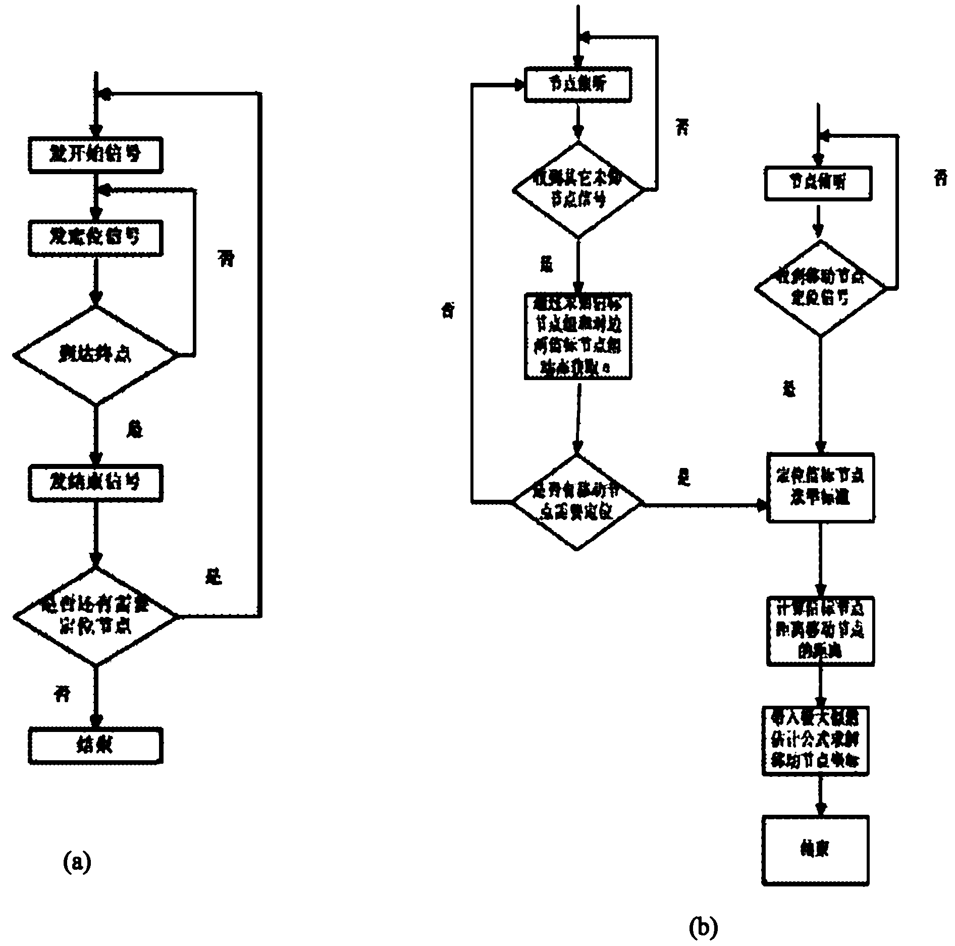
[0017] see Figure 1-Figure 3 (a), image 3 (b) A dynamic α positioning method for downhole linear wireless sensor networks based on RSSI similarity. This method adopts the deployment of rectangular grouping of beacon nodes in downhole linear wireless sensor networks, and uses the information dynamics of the group to be tested and the adjacent two groups on the opposite side. The path loss index α at each location is obtained to reduce the non-line-of-sight measurement error and obtain an accurate measurement distance; on this basis, the mobile node selects the required beacon node for positioning through the RSSI similarity.

[0018] In the rectangular group deployment of the underground linear wireless sensor network beacon nodes, each group places a corresponding number of beacon nodes according to actual needs and numbers them sequentially, and ensures that there is always one beacon node in each group through the corresponding protocol. active state.

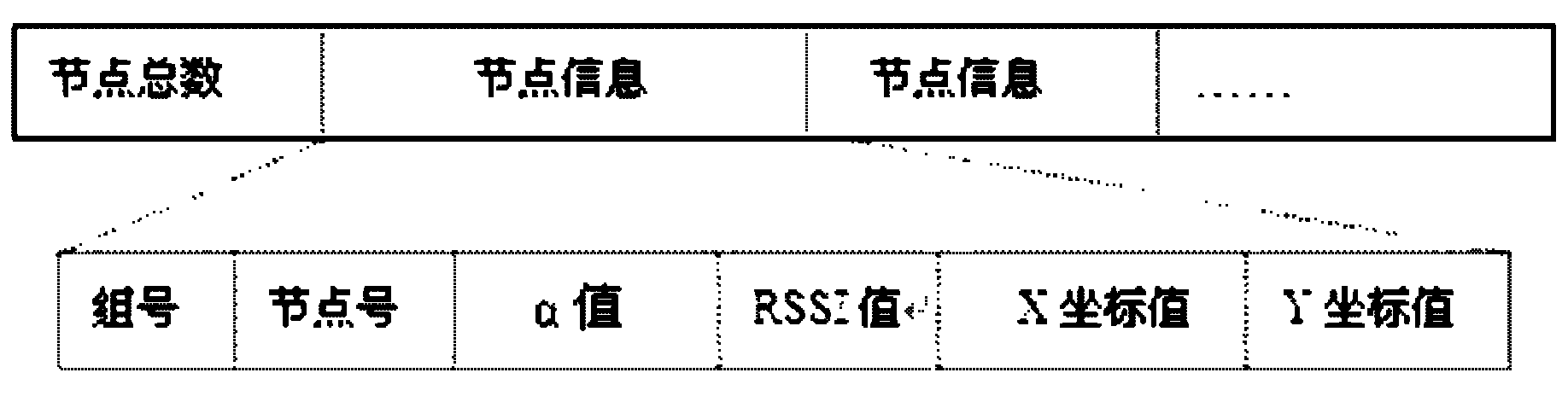
[0019] Use the ac...


PUM


Abstract

The invention relates to a RSSI (Receive Signal Strength Indicator) similarity-based underground linear wireless sensor network dynamic alpha positioning method which is designed to solve the problem of a larger positioning error generated under the condition that the path consumption indexes of all positions of the mine underground are obtained and the RSSI value is simply used for reflecting the environment similar degree among wireless sensor nodes. The method comprises the following steps of: dynamically obtaining the path consumption index alpha of all positions by adopting the information of a group to be detected and opposite adjacent two groups to reduce a non-line-of-sight measurement error and obtain accurate measurement distance; meanwhile, selecting a beacon node which is closest to the movement node for positioning by RSSI similarity. The invention has the characteristics and advantages of enabling the information of the opposite adjacent two groups to dynamically obtain the path consumption index alpha of all the positions in the rectangular grouping deployment of the group to be detected and the underground linear wireless sensor network beacon node, overcoming the easy generated non-line-of-sight error generated under the traditional linear sensor network and obtaining the accurate measurement distance; and the invention has low requirement on the hardware, reduces the cost and greatly improves the positioning precision.

Description

technical field [0001] The invention relates to an underground linear wireless sensor network dynamic α positioning method based on RSSI similarity under complex environment conditions with different path loss indices in underground coal mines. Background technique [0002] In recent years, there are still many safety hazards in my country's coal mines, and mine accidents occur from time to time. After the accident, it is very important to accurately obtain the location of the trapped people and monitor the environmental conditions of the accident place for rescue. Due to the complex underground environment and cumbersome deployment lines, it is difficult for traditional wired networks to complete safety monitoring tasks underground. With the development of wireless sensor networks, wireless sensor networks are applied to coal mines to monitor the underground environment and obtain the location of underground personnel. To make up for some defects of wired devices, it has th...

Claims


Application Information

Patent Timeline
Patent Type & Authority Applications(China)
IPC IPC(8): H04W64/00
Inventor 田丰董莹
Owner SHENYANG AEROSPACE UNIVERSITY
Why Eureka
Try Eureka