Constructing method for absolute orientation model of airborne InSAR DEM

A construction method and model technology, applied in the field of surveying and mapping, can solve the problems of DEM products, such as the influence of elevation accuracy, no use, no positioning model, etc., and achieve the effect of high precision, fast convergence speed, and simple mathematical principles

Inactive Publication Date: 2012-07-11
CHINESE ACAD OF SURVEYING & MAPPING
View PDF3 Cites 4 Cited by
  • Summary
  • Abstract
  • Description
  • Claims
  • Application Information

AI Technical Summary

Problems solved by technology

However, these models do not use the high-precision relative elevation information in the slant-range DEM, nor do they deal with the errors in the interferometric calibration, w...

Method used


Image

  • Constructing method for absolute orientation model of airborne InSAR DEM
  • Constructing method for absolute orientation model of airborne InSAR DEM
  • Constructing method for absolute orientation model of airborne InSAR DEM

Examples


Embodiment Construction

[0017] In order to describe the technical content, structural features, achieved objects and effects of the present invention in detail, the following detailed description is given in conjunction with the specific embodiments and the accompanying drawings.

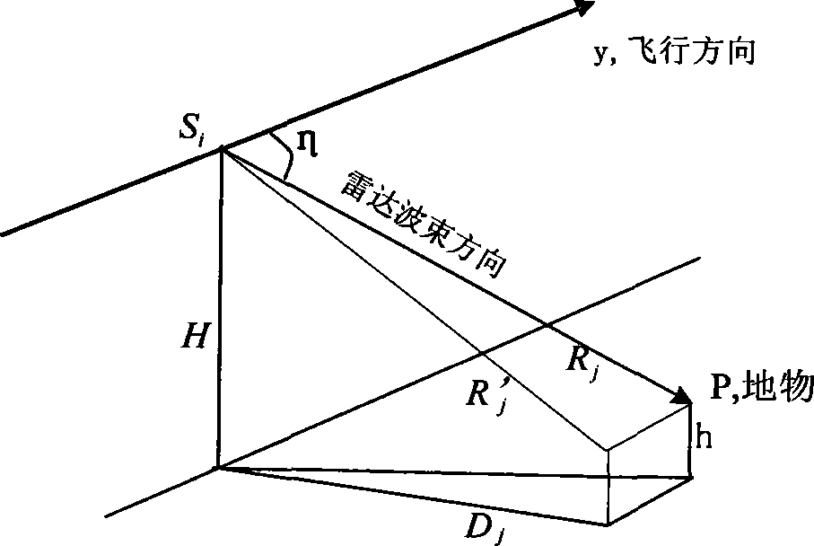
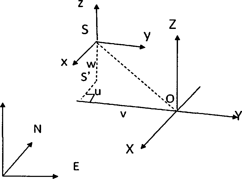
[0018] In order to realize high-precision InSAR DEM geocoding, the present invention proposes a method for constructing an airborne InSARDEM absolute orientation model. The method includes: step 1, correcting the displacement of the image point caused by the terrain fluctuation by using the slant distance ground distance transformation, and converting the slope distance DEM to the ground distance DEM. Step 2: According to the spatial similarity transformation, the ground distance DEM is regarded as a rigid body, and its deformation is regarded as a combination of translation, scaling, and rotation, and the elevation information in the image coordinate system is projected into the geographic coordinate system; Step 3, based ...


PUM


Abstract

The invention relates to a constructing method for an absolute orientation model of an airborne InSAR DEM (Interferometric Synthetic Aperture Radar Digital Elevation Model). The constructing method for the model comprises the following steps: firstly, converting a slope-distance DEM into a ground distance DEM; and secondly, considering the ground distance DEM into a rigid body according to spatial similarity transformation, considering the deformation of the ground distance DEM as a combination of translating, zooming and rotating and realizing the resolving from SAR image coordinate jointed slope-distance DEM elevation information to ground three-dimensional coordinates. The constructing method can be used for SAR image positioning, InSAR DEM geocoding and InSAR area network joint geocoding of the InSAR. The realized model is simple in mathematical principle, high in convergence rate and high in precision. In addition, the realized model not only can be used for geocoding for single-shot InSAR DEM, but also can be used for the area network joint geocoding.

Description

technical field [0001] The invention relates to the technical field of surveying and mapping, and more particularly, to a method for constructing an airborne InSAR DEM absolute orientation model. Background technique [0002] Synthetic Aperture Radar Interferometry (InSAR) uses the phase information of radar waves to extract a high-precision digital elevation model (DEM). It is one of the key technologies in SAR topographic mapping. The non-geocoded DEM obtained by interferometric processing is the slant range DEM, which has high-precision relative elevation information. However, due to the expression of the slant range, it cannot be used directly and needs to be geocoded; at the same time, there are errors in the interferometric geometric calibration, which will also bring errors to the elevation information of the slant range DEM. [0003] The basis of InSAR DEM geocoding is the SAR image positioning model. At present, a variety of SAR image positioning models have been p...

Claims


Application Information

Patent Timeline
IPC IPC(8): G01C5/00G01S13/90
Inventor 黄国满杨书成张继贤王宁娜赵争
Owner CHINESE ACAD OF SURVEYING & MAPPING
Why Eureka
Try Eureka