
Water source area monitoring and evaluation method

An evaluation method and water source technology, applied in the direction of testing water, measuring devices, instruments, etc., can solve the problems of long time period, high cost, heavy workload, etc., and achieve the effect of convenient monitoring and evaluation

Active Publication Date: 2012-07-11
SATELLITE ENVIRONMENT CENT MINIST OF ENVIRONMENTAL PROTECTION
View PDF4 Cites 34 Cited by
  • Summary
  • Abstract
  • Description
  • Claims
  • Application Information

AI Technical Summary

Problems solved by technology

[0006] At present, the monitoring of water sources is mainly carried out in a "bottom-up" manner, with statistics collected by grassroots units and collected by higher-level units. This monitoring method requires a long period of time, heavy workload and high cost.

Method used


Image

  • Water source area monitoring and evaluation method
  • Water source area monitoring and evaluation method
  • Water source area monitoring and evaluation method

Examples


Embodiment Construction

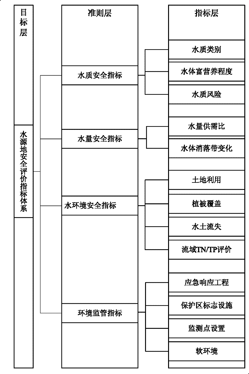
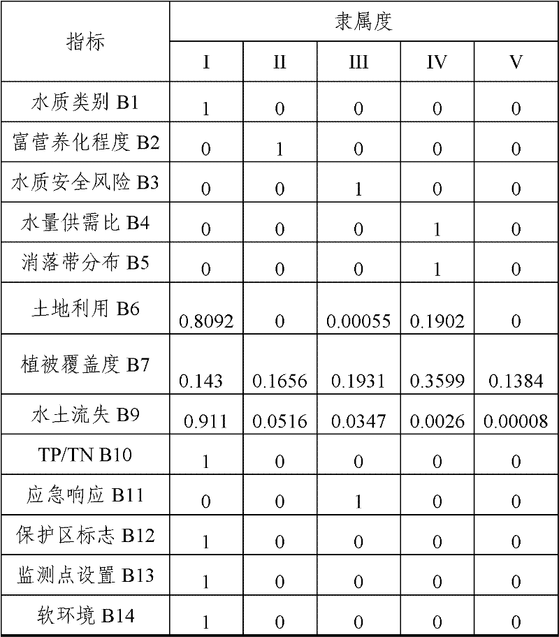
[0044] The water source monitoring and evaluation method proposed by the present invention is described in detail as follows in conjunction with the accompanying drawings and examples.

[0045] The "Environment-1" (HJ-1A / B) satellite system is an earth observation system approved by the State Council of China for environmental and disaster monitoring. All-day, dynamic environment and disaster monitoring capabilities. HJ-1A / B star data can not only provide an important guarantee for the environment and disaster reduction business operation system, but also become an important data source for the daily business of many departments. The environment and disaster reduction application system based on environmental satellite data has an important demonstration role in promoting remote sensing satellite business services. The observation satellite mentioned in the present invention is preferably HJ-1A / B, and the remote sensing data of the observation satellite especially refers to t...


PUM


Abstract

The invention discloses a water source area monitoring and evaluation method comprising the steps that: S1, safety evaluations are carried out upon various evaluation indexes of a water source area according to ground water source area monitoring data, observation satellite remote sensing data, and auxiliary data thereof; S2, weight coefficients of the evaluation indexes of the water source area are calculated with an analytic hierarchy process; S3, a water source area safety grade is globally evaluated based on a fuzzy mathematic method, and an early warning mechanism and an emergency mechanism are established according to the evaluation result. According to the method provided by the invention, an air-ground coordination method is adopted, and observation satellite remote sensing data and ground monitoring data are combined, such that the distribution condition of the indexes used for evaluating the water source area safety is obtained; combined with the evaluation standards of the indexes, safety grades of the indexes are obtained; weight effects of the indexes are considered, and a global safety grade of the water source area can be obtained. Therefore, large-area land surface water source area monitoring and evaluation can be rapidly and conveniently realized, and effective complementation is provided for ground monitoring stations.

Description

technical field [0001] The invention relates to the technical field of monitoring and evaluation of surface drinking water sources, in particular to a water source monitoring and evaluation method based on ground data and observation satellite remote sensing data. Background technique [0002] With the rapid economic and social development of our country, the continuous growth of population and the gradual increase of urbanization rate, the environmental pressure faced by water sources has increased significantly, and the overall water quality has shown a downward trend. Shut off water source. At present, the healthy development of the water environment in the basin is challenged by previous actions, especially the healthy development of drinking water sources in the basin has become the top priority. [0003] As one of the most important water resources, drinking water currently has many problems in terms of water quality, water quantity and resource management. The issue...

Claims


Application Information

Patent Timeline
IPC IPC(8): G01N33/18G01N21/00
Inventor 姚延娟吴传庆王桥王雪蕾张永军朱利马万栋殷守敬
Owner SATELLITE ENVIRONMENT CENT MINIST OF ENVIRONMENTAL PROTECTION
Learn More