Intersection map matching method based on driver behavior characteristics and logit model

A technology of map matching and logarithmic model, which is applied in the field of vehicle positioning and map matching, and can solve the problems of low map matching accuracy and low real-time performance

Inactive Publication Date: 2012-07-18
JILIN UNIV
View PDF2 Cites 37 Cited by
  • Summary
  • Abstract
  • Description
  • Claims
  • Application Information

AI Technical Summary

Problems solved by technology

[0004] Aiming at the current problems of low map matching accuracy and low real-time performance at intersections, the present invention proposes a map matching method at intersections based on driver behavior characteristics and a logarithmic model, which realizes high-precision, real-time position

Method used


Image

  • Intersection map matching method based on driver behavior characteristics and logit model
  • Intersection map matching method based on driver behavior characteristics and logit model
  • Intersection map matching method based on driver behavior characteristics and logit model

Examples


Embodiment Construction

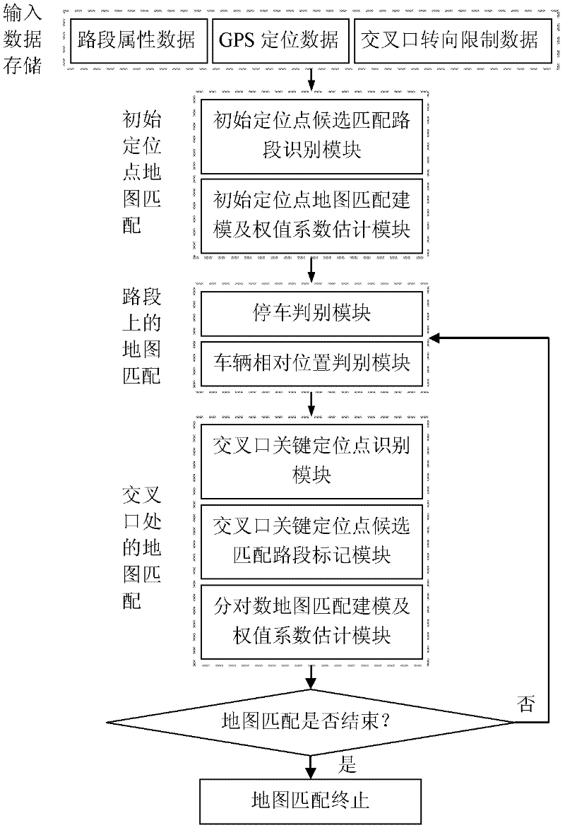
[0027] Phase 1: Input Data Storage

[0028] The input data of map matching includes road segment attribute data in digital electronic map, GPS positioning data of vehicle position and intersection steering restriction data. details as follows:

[0029] 1) Road section attribute data in the digital electronic map: the number of the road section, the number and coordinates of the starting point and the end point of the road section (the digital electronic map adopts the WGS 84 coordinate system, which is the same as the GPS coordinate system);

[0030] 2) GPS positioning data of the vehicle position: longitude and latitude coordinates of the vehicle position received by the vehicle-mounted GPS receiver, vehicle driving direction, vehicle speed, data receiving time (with 1 second as the time interval for data receiving);

[0031] 3) Intersection steering restriction data: the steering restriction data of each connecting road section of the intersection in the direction of the en...


PUM


Abstract

The invention provides an intersection map matching method based on driver behavior characteristics and a logit model, relating to the field of vehicle positioning and map matching. The method comprises four phases of storing input data, mapping an initial site map, matching a map on a road section and matching an intersection map, so as to finish high-precision and real-time positioning of a vehicle driving track. The intersection map matching method disclosed by the invention solves the problem that the matching precision of the intersection map is low and overcomes the defect of the traditional intersection map matching method, so that the high-precision and real-time positioning of an intersection is realized.

Description

technical field [0001] The invention relates to the field of vehicle positioning and map matching, and is a vehicle positioning technology and a map matching method at an intersection, in particular to a map matching method at an intersection based on driver behavior characteristics and a logarithmic model. Background technique [0002] Map matching is an effective means to improve the accuracy of vehicle positioning. It is mainly based on the longitude and latitude coordinates of the vehicle location point provided by the Global Position System (GPS) to find the road section where the location point is located and the location point on the road section on the digital electronic map. Urban intersections are the key hubs for vehicles to change driving directions and change driving sections. Map matching at urban intersections is the core and difficult point of map matching method research. The traditional map matching method mainly starts with the analysis of the spatial geo...

Claims


Application Information

Patent Timeline
Patent Type & Authority Applications(China)
IPC IPC(8): G01C21/30
Inventor 龚勃文林赐云杨兆升于德新
Owner JILIN UNIV
Why Eureka
Try Eureka