Topographical map high-fidelity reducing method utilizing rotating TIN (triangulated irregular network) overlay analysis

A topographic map, high-fidelity technology, applied in graphics and image conversion, image data processing, instruments, etc., to achieve the effect of improving distortion problems, saving sampling points, and large coverage

Inactive Publication Date: 2012-10-31
黄桂芝
View PDF2 Cites 2 Cited by
  • Summary
  • Abstract
  • Description
  • Claims
  • Application Information

AI Technical Summary

Problems solved by technology

[0003] The purpose of the present invention is to provide a high-fidelity map reduction method using rotating TIN network superimposition analysis to solve the problem of distortion only by increasing the number of sampling points when the existing square or rectangular network shrinks the map serious flaw

Method used


Image

  • Topographical map high-fidelity reducing method utilizing rotating TIN (triangulated irregular network) overlay analysis
  • Topographical map high-fidelity reducing method utilizing rotating TIN (triangulated irregular network) overlay analysis
  • Topographical map high-fidelity reducing method utilizing rotating TIN (triangulated irregular network) overlay analysis

Examples


specific Embodiment approach 1

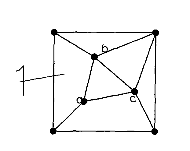
[0007] Specific implementation mode one: the following combination Figure 1 to Figure 7 This embodiment will be specifically described. The present embodiment comprises the following steps: 1. In the present embodiment, 10m (measured on a drawing scale) is used as the side length of the basic square of the rotating TIN network. 2. Arrange one sampling point at each of the four vertices of the basic square, and distribute 3 sampling points in the basic square, a total of 7 sampling points, and the distance between any two of the 3 sampling points scattered in the square Between 0.20 and 0.85 times the side length of the basic square. The vertices of the basic square and the internal sampling points are connected by triangles to ensure that the length of the connection between any two adjacent sampling points is between 0.20 and 0.85 times the side length of the basic square, which has good interlacing and dispersion. All interior angles of all triangles in the basic square s...

specific Embodiment approach 2

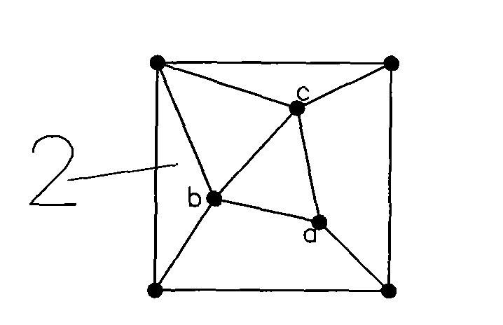
[0008] Embodiment 2: The difference between this embodiment and Embodiment 1 is that step A is also included between step 4 and step 5, scaling the length or width of the supporting unit to make it a rectangle, and the positions of all sampling points inside Adjust as stated. Other steps are the same as those in Embodiment 1.

specific Embodiment approach 3

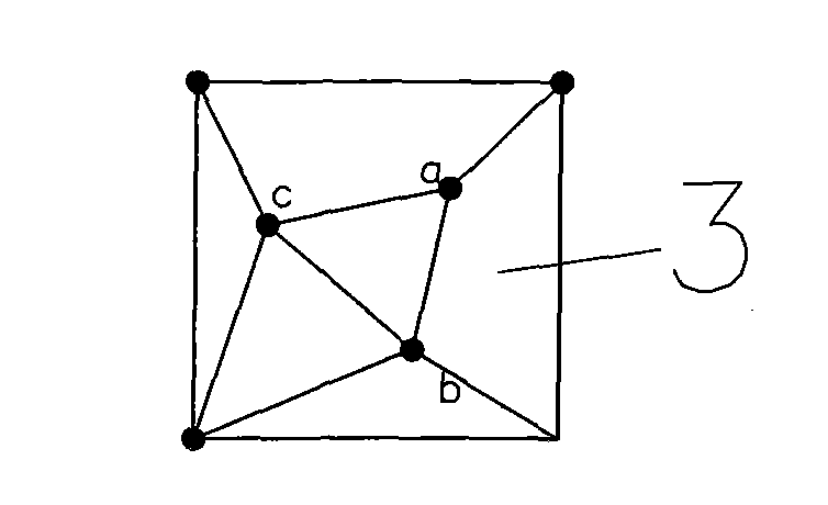
[0009]Specific embodiment three; see schematic diagram 8 to schematic diagram 13, the difference between this embodiment and embodiment one is: in step two, the three surveying and mapping points dispersedly arranged in the basic square are respectively, a (6, 6), b(15, 24), c(24, 15); other steps are the same as those in Embodiment 1.


PUM


Abstract

A topographical map high-fidelity reducing method utilizing rotating TIN (triangulated irregular network) overlay analysis overcomes the shortcoming that an existing square or rectangular network is severe in distortion when a topographical map is reduced. The topographical map high-fidelity reducing method comprises the following steps of determining the side length of a basic square; respectively arranging four sampling points at four vertexes of the basic square, and arranging 3-n sampling points on sides of the basic square and the inside of the basic square in a scattered manner to form a basic unit; counterclockwise rotating the basic unit to form a primary unit body, a secondary unit body and a tertiary unit body; splicing the basic unit, the primary unit body, the secondary unit body and the tertiary unit body to form a square assorted unit; utilizing the assorted unit as a replication unit, and performing translation replication repeatedly to form a rotating staggered assorted network covering a topographical map; respectively utilizing a unit in the assorted unit as a start unit of a rotating staggered scaling network to reduce the topographical map; and comprehensively analyzing after overlaying 4 reduced results, and selecting useful results to obtain a reduced synthesized topographical map.

Description

technical field [0001] The invention relates to a high-fidelity reduction method for topographic maps. Background technique [0002] Existing high-fidelity topographic map reduction methods use the intersection of square or rectangular grids as sampling points when reducing, whether it is mechanical modeling or feature modeling. The disadvantages of using square or rectangular grids are: 1. Only plane coordinates are considered, and the rationality of the third-dimensional data distribution is not considered. 2. The trend of terrain changes along the direction of strike and slope is not considered; 3. The organic response of adjacent triangles is not considered to better control the terrain; 4. A fixed network density is used in a region to form a There is no relatively dense area and relatively sparse area under a certain network density, and the obtained data is the overall average trend of the area. There is neither a key detailed area, nor can the trend of the detailed ...

Claims


Application Information

Patent Timeline
Patent Type & Authority Applications(China)
IPC IPC(8): G06T3/40
Inventor 黄桂芝
Owner 黄桂芝
Why Eureka
Try Eureka