Display style setting method of vector electronic map information

An electronic map and style technology, applied in the direction of electronic digital data processing, data processing input/output process, instruments, etc., can solve the problems of inconvenient use, not supporting the setting of map display style, and the difficulty for users to distinguish the types of geographic information, etc., to achieve Enhance visual effects, style and content-rich effects

Active Publication Date: 2014-08-06
哈尔滨哈船导航技术有限公司
View PDF1 Cites 0 Cited by
  • Summary
  • Abstract
  • Description
  • Claims
  • Application Information

AI Technical Summary

Problems solved by technology

However, in this display mode with a fixed element style, the user cannot highlight the specified element on the map according to the needs, especially when the map contains too many types of elements, it is inevitable that there will be elements with similar display styles, which makes the user distinguish the types of geographic information Difficulties arise and inconvenience to users
while the existing electronic Figure 1 Generally, it does not support map display style setting. The patent "Navigation System and Its Display Color Setting Method" mentions that the display color of the electronic map and user interface in the navigation system can be set, but this method cannot completely solve the above problems

Method used


Image

  • Display style setting method of vector electronic map information
  • Display style setting method of vector electronic map information
  • Display style setting method of vector electronic map information

Examples


Embodiment

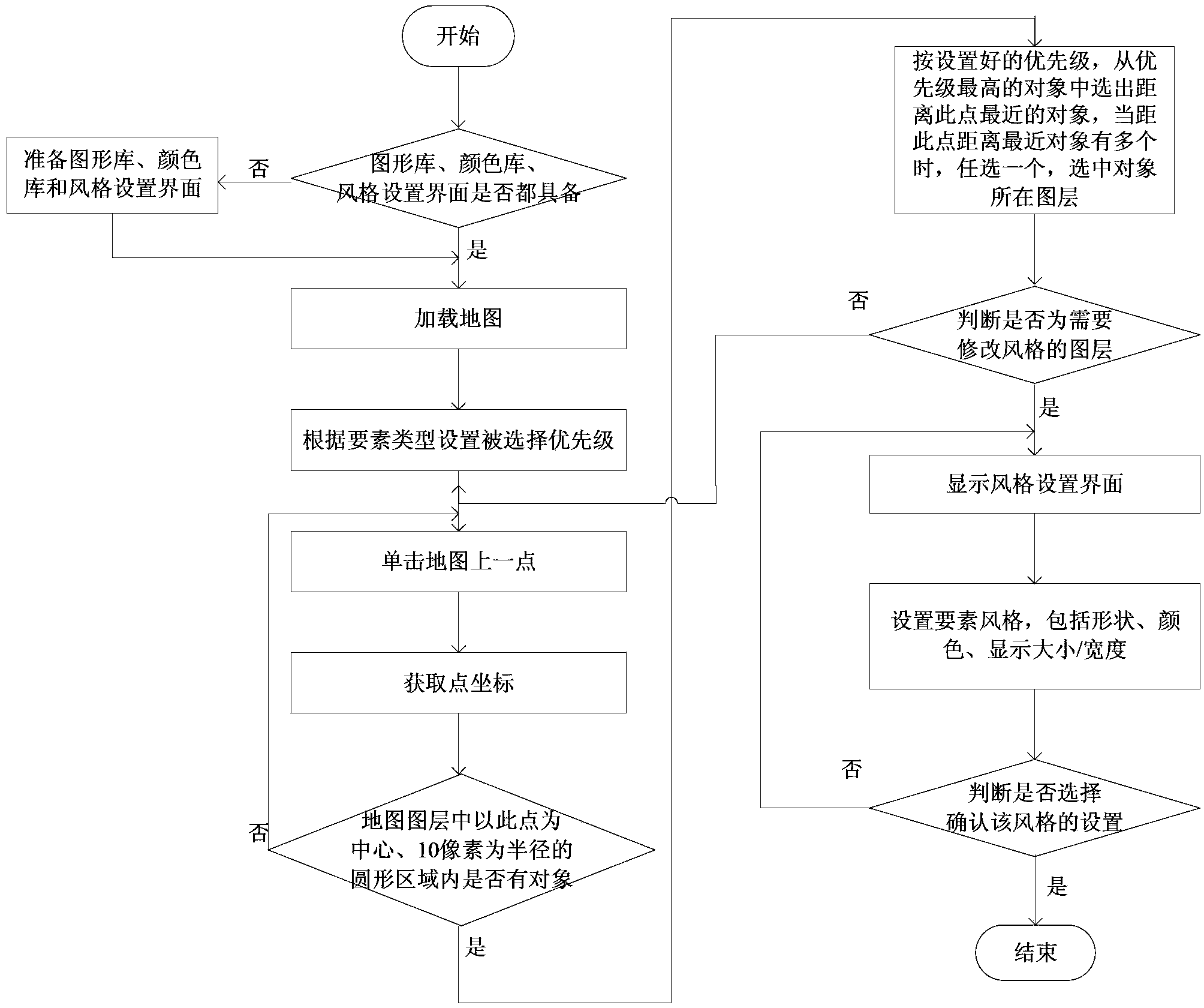
[0030] The display style setting method of the present invention is explained by modifying the style of railway elements in the vector electronic map, which mainly includes the following steps:

[0031] Step 1: Before modifying the display style of the map elements, first check whether all the prerequisites are met. The conditions include: whether the graphics library made by the user using the drawing software to represent the element style is ready, whether the color library is loaded, and whether the style is established Set the interface, these conditions must be met, proceed to the next step, otherwise continue to prepare the corresponding prerequisites;

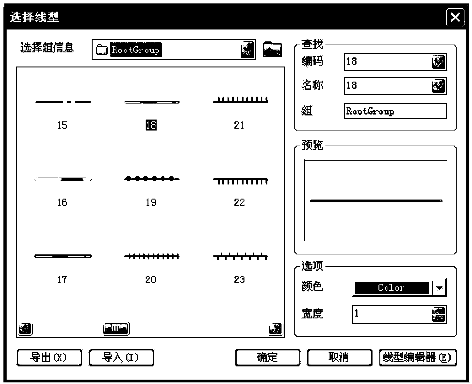
[0032] The graphics in the graphics library include both general graphics and graphics drawn by the user's application drawing software, including three types of graphics, point, line, and surface. The color library is a system color library that contains all colors. The style setting interface includes setting elements. The...


PUM


Abstract

The invention discloses a display style setting method of vector electronic map information and belongs to the technical field of geographical information system map arrangement. The display style setting method includes: checking whether prerequisite conditions are already; loading a map, wherein selected priority level is set according to map element types; clicking any point on a map, obtaining the coordinate of the point, and judging whether map element objects exist in a circular area formed with a point selected from all layers displayed in the map as the center and the radius as 10 pixels; judging whether a selected layer is a layer with the style to be modified by a user; and the like. According to the display style setting method, the user can use a picture base built by the user and representing the map element types as required, set the selected priority level according to objects needed to be selected, fast and accurately select the layers where the elements are located, modify the element style and enrich contents, select appropriate style display elements autonomously and modify the style of the selected layers for many times. The display style setting method improves visual effect of an electronic map.

Description

Technical field [0001] The invention belongs to the technical field of geographic information system map configuration, and specifically relates to a method for setting the display style of vector electronic map information. Background technique [0002] With the gradual increase in the digitalization of the world today, electronic maps have been used in many areas of life because of their convenient and quick features to provide people with rich geographic information. Compared with the image data electronic map, the vector electronic map has the advantages of vector zoom and high resolution, which brings more convenience to users. According to the vector data types, electronic maps usually include point data such as capitals, provincial capital cities, prefecture-level cities, railways, highways, single-line rivers and other line data, and also include double-line rivers, national boundaries, provincial boundaries, and city boundaries. According to the characteristics of vecto...

Claims


Application Information

Patent Timeline
Patent Type & Authority Patents(China)
IPC IPC(8): G06F3/0481
Inventor 沈志峰吴迪张振兴高峰
Owner 哈尔滨哈船导航技术有限公司
Why Eureka
Try Eureka