Method and device for decision tree based wide-area remote sensing image classification

A decision tree classification, remote sensing image technology, applied in instruments, character and pattern recognition, computer parts and other directions, can solve the problem of lack of classification strategies and algorithms in remote sensing image classification, and achieve the effect of improving classification accuracy

Active Publication Date: 2012-12-19
CHINESE ACAD OF SURVEYING & MAPPING
View PDF0 Cites 17 Cited by
  • Summary
  • Abstract
  • Description
  • Claims
  • Application Information

AI Technical Summary

Problems solved by technology

There is a lack of corresponding classification strategies and algorithms in remote sensing i

Method used


Image

  • Method and device for decision tree based wide-area remote sensing image classification
  • Method and device for decision tree based wide-area remote sensing image classification
  • Method and device for decision tree based wide-area remote sensing image classification

Examples


Embodiment Construction

[0036] The following will clearly and completely describe the technical solutions in the embodiments of the present invention with reference to the accompanying drawings in the embodiments of the present invention. Obviously, the described embodiments are only some, not all, embodiments of the present invention. Based on the embodiments of the present invention, all other embodiments obtained by persons of ordinary skill in the art without making creative efforts belong to the protection scope of the present invention.

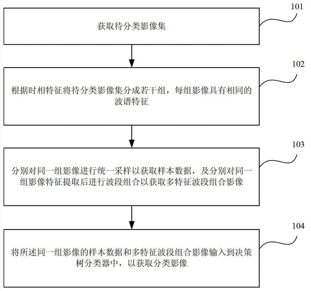
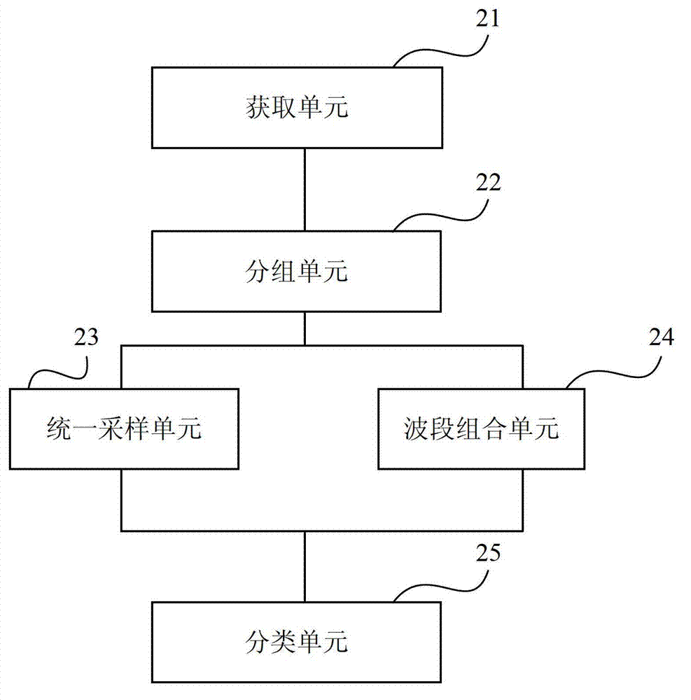
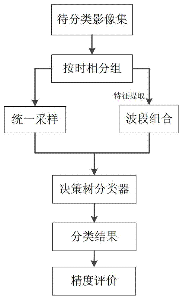
[0037] Such as figure 1 As shown, it is a flowchart of a wide-area remote sensing image decision tree classification method according to an embodiment of the present invention. The wide-area remote sensing image decision tree classification method includes:

[0038] 101. Obtain an image set to be classified;

[0039] 102. Divide the image set to be classified into several groups according to the temporal characteristics, and each group of images has the same ...


PUM


Abstract

An embodiment of the invention provides a method and a device for decision tree based wide-area remote sensing image classification. The method includes acquiring an image set to be classified; dividing the image set to be classified into multiple groups according to time phase characteristics and enabling each group of images to have the same spectrum characteristics; respectively sampling the same groups of images uniformly to acquire sample data, extracting characteristics of the same groups of images, and then carrying out band combination so as to acquire multi-characteristic band-combination images; and inputting the sample data and the multi-characteristic band-combination images of the same groups of images to a decision tree classifier to acquire classified images. The method and the device have the technical advantages that a wide-area land cover classification decision according to decision tree based sensing image classification is provided, and wide-area remote sensing image classification precision is improved.

Description

technical field [0001] The invention relates to classification of remote sensing images, in particular to a wide-area remote sensing image decision tree classification method and device. Background technique [0002] Remote sensing images are image data that reflect the spatial distribution and spectral information of the earth's surface features and spectral information acquired by spaceborne or airborne sensors. It has the characteristics of wide coverage and short imaging period. With the development of remote sensing image classification technology, remote sensing image Classification techniques are increasingly used in wide-area land cover classification. The existing remote sensing image classification methods and systems include: minimum distance method, parallelepiped method, maximum likelihood method, ISODATA (iterative self-organizing data analysis technology), K-Means (K-means clustering method), etc. Supervised classification methods, as well as emerging fuzzy c...

Claims


Application Information

Patent Timeline
IPC IPC(8): G06K9/62
Inventor 翟亮张晓贺桑会勇李奇伟杨刚王晓军邱程锦贾毅
Owner CHINESE ACAD OF SURVEYING & MAPPING
Why Eureka
Try Eureka