Method and device for generating ephemeris message of glonass satellite signal
A satellite signal and satellite technology, applied in the field of satellite navigation simulation, can solve problems such as text simulation of difficult GLONASS satellite signals
- Summary
- Abstract
- Description
- Claims
- Application Information
AI Technical Summary
Problems solved by technology
Method used
Image
Examples
Embodiment 1
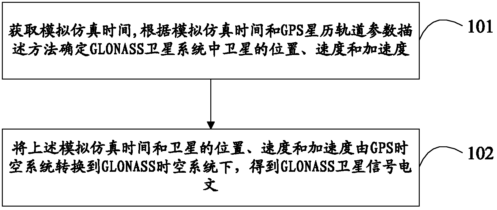
[0056] Embodiment 1 of the present invention proposes a kind of GLONASS satellite signal ephemeris message generation method, and its flow process is as follows figure 1 shown, including:
[0057] Step 101, obtain the simulation time, determine the position, velocity and acceleration of the satellite in the GLONASS satellite system according to the simulation time and the GPS ephemeris orbit parameter description method;
[0058] Step 102, converting the above-mentioned simulation time and the position, velocity and acceleration of the satellite from the GPS space-time system to the GLONASS space-time system to obtain the GLONASS satellite signal ephemeris message.
[0059] Through the method for generating a GLONASS satellite signal ephemeris message provided by the embodiment of the present invention, the message of the GLONASS satellite signal can be simulated under the situation that the ephemeris information of the GLONASS satellite system cannot be known by this method, ...
Embodiment 2
[0061] Embodiment 2 of the present invention proposes a method for generating GLONASS satellite signal ephemeris text, which is improved on the basis of Embodiment 1.
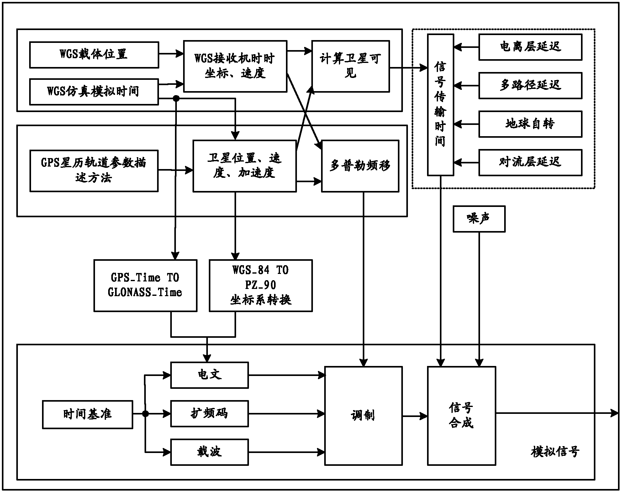
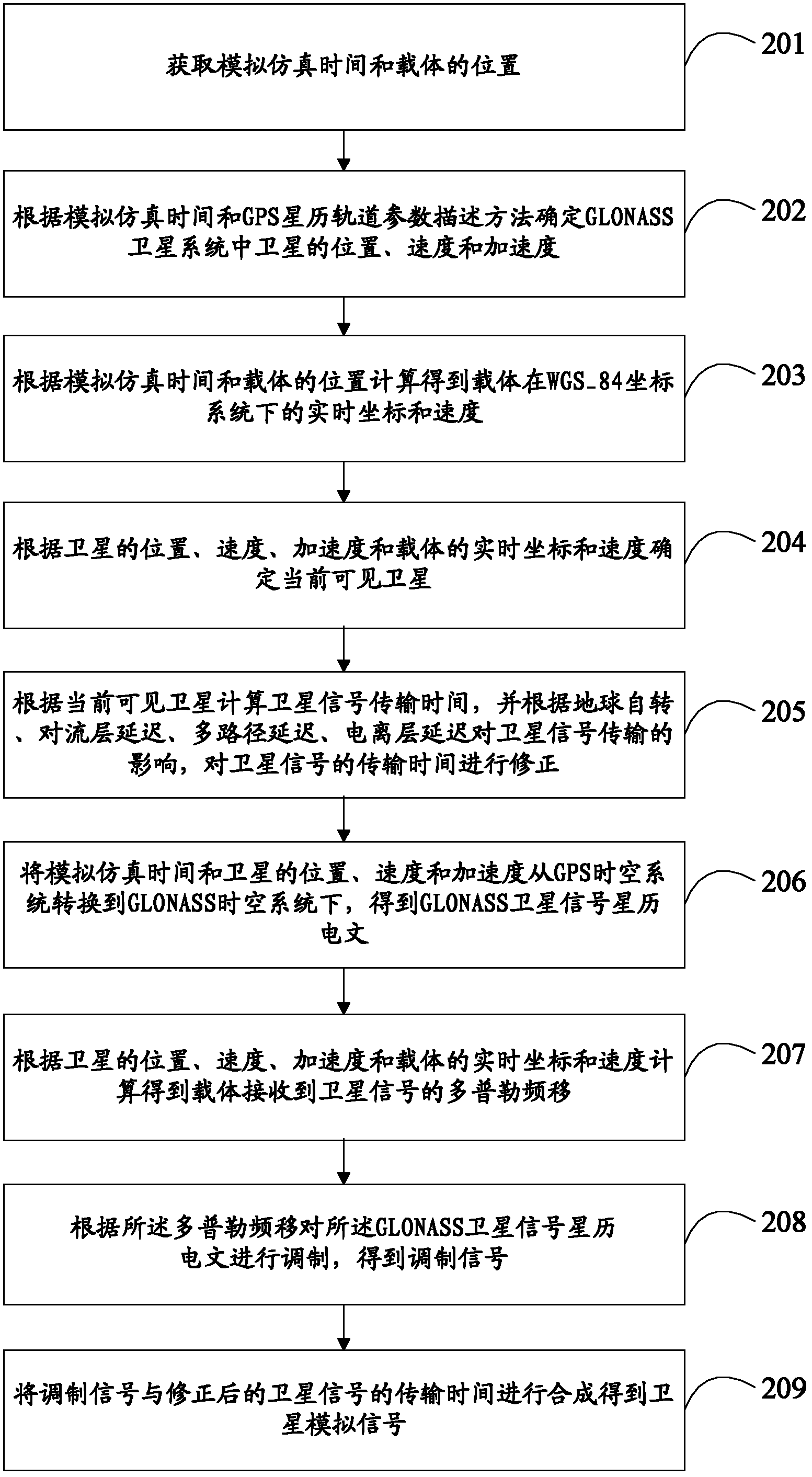
[0062] It should be noted that, in this embodiment, a method for generating a GLONASS satellite signal ephemeris message is provided, and a method for generating a satellite analog signal based on the GLONASS satellite signal ephemeris message is provided.
[0063] Such as figure 2 and image 3 As shown, the method specifically includes:
[0064] Step 201, obtaining the simulation time and the location of the carrier;
[0065] Wherein, the simulation time is specifically the simulation time under the GPS_Time time system, and the position of the carrier is specifically the coordinates of the carrier under the WGS_84 coordinate system;
[0066] It should be noted that WGS_84 is a coordinate system established for use by the GPS global positioning system. The geometric meaning of the WGS_84 coordinate system...
Embodiment 3
[0177] Such as Figure 4 As shown, embodiment 3 of the present invention provides a kind of GLONASS satellite signal ephemeris message generation device, and this device comprises:
[0178] The first module 301 is used to obtain the simulation simulation time, and determine the position, velocity and acceleration of the satellite in the GLONASS satellite system according to the simulation simulation time and the GPS ephemeris orbit parameter description method;
[0179] The second module 302 is used to convert the simulation time and the position, velocity and acceleration of the satellite from the GPS space-time system to the GLONASS space-time system to obtain the GLONASS satellite signal ephemeris message.
[0180] Further, as Figure 5 As shown, the first module 301 specifically includes:
[0181] The first unit 3011, the user acquires the simulation time;
[0182] The second unit 3012 is used to determine the position of the satellite in the GLONASS satellite system us...
PUM
| Property | Measurement | Unit |
|---|---|---|
| Inclination | aaaaa | aaaaa |
Abstract
Description
Claims
Application Information
 - R&D
- Intellectual Property
- Life Sciences
- Materials
- Tech Scout
- Unparalleled Data Quality
- Higher Quality Content
- 60% Fewer Hallucinations
Browse by: Latest US Patents, China's latest patents, Technical Efficacy Thesaurus, Application Domain, Technology Topic, Popular Technical Reports.
© 2025 PatSnap. All rights reserved.Legal|Privacy policy|Modern Slavery Act Transparency Statement|Sitemap|About US| Contact US: help@patsnap.com


