Tri-mode positioning and navigation system based on BD-1 (Beidou-1)/BD-2 (Beidou-2)/GPS (global position system)

A positioning and navigation, three-mode technology, applied in the field of positioning and navigation systems based on Beidou-1/Beidou-2/GPS three-mode, can solve the problems of rare products, and achieve the effects of convenient operation, high receiving sensitivity and high sensitivity

Active Publication Date: 2013-04-03
武汉中元通信股份有限公司
View PDF6 Cites 7 Cited by
  • Summary
  • Abstract
  • Description
  • Claims
  • Application Information

AI Technical Summary

Problems solved by technology

[0005] However, most of the various satellite positioning and navigation systems that have come out are single-GPS or single-Beidou-mo

Method used


Image

  • Tri-mode positioning and navigation system based on BD-1 (Beidou-1)/BD-2 (Beidou-2)/GPS (global position system)
  • Tri-mode positioning and navigation system based on BD-1 (Beidou-1)/BD-2 (Beidou-2)/GPS (global position system)
  • Tri-mode positioning and navigation system based on BD-1 (Beidou-1)/BD-2 (Beidou-2)/GPS (global position system)

Examples


Example Embodiment

[0052] see Figure 1 to Figure 5 Shown is a specific embodiment of the present invention.

[0053] from Figure 1 to Figure 3 As can be seen:

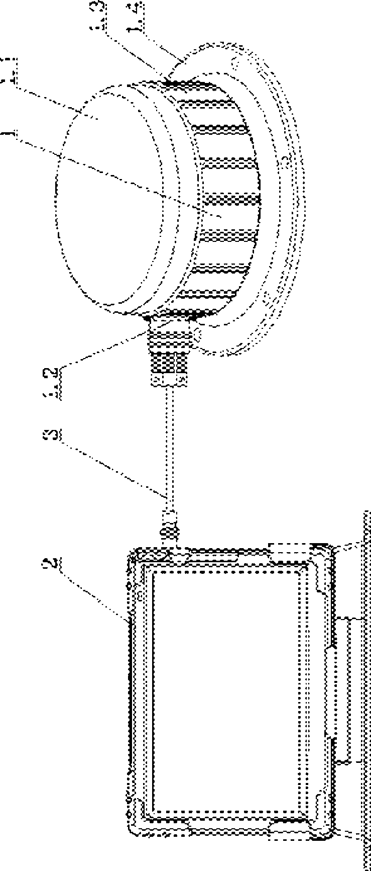
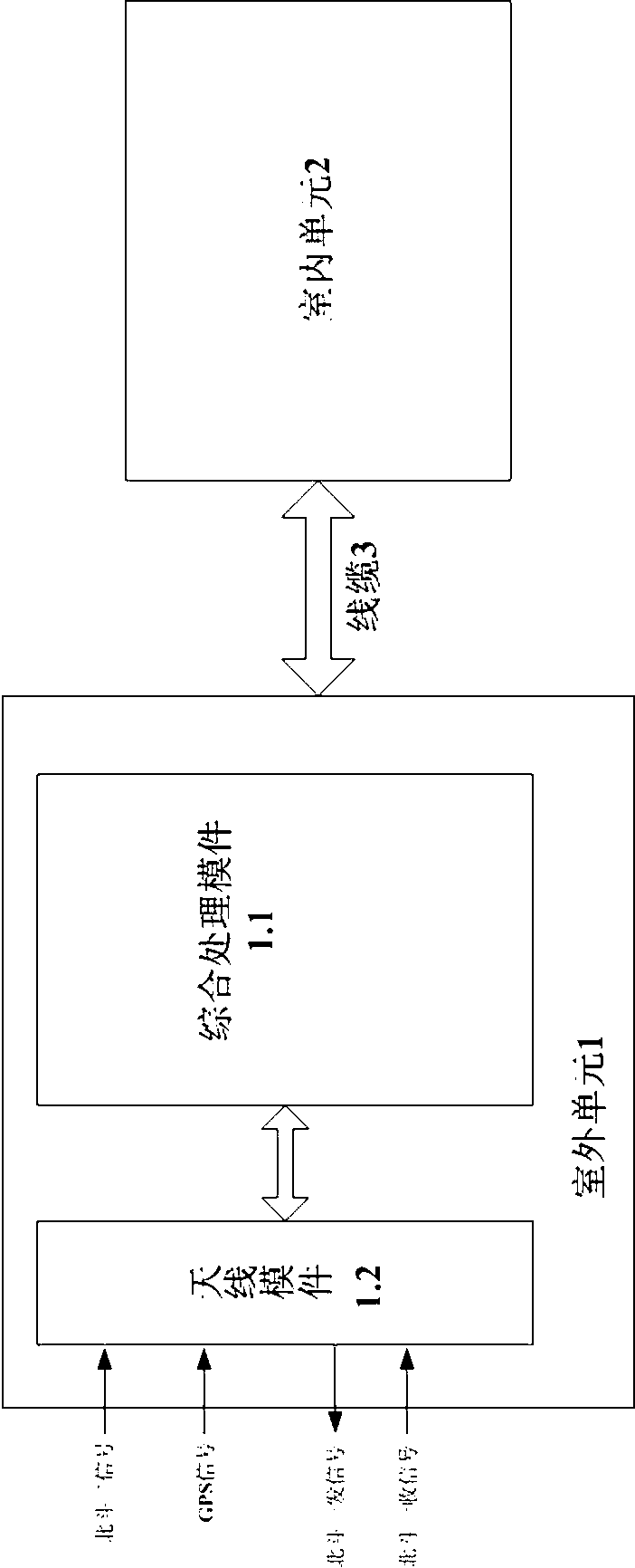
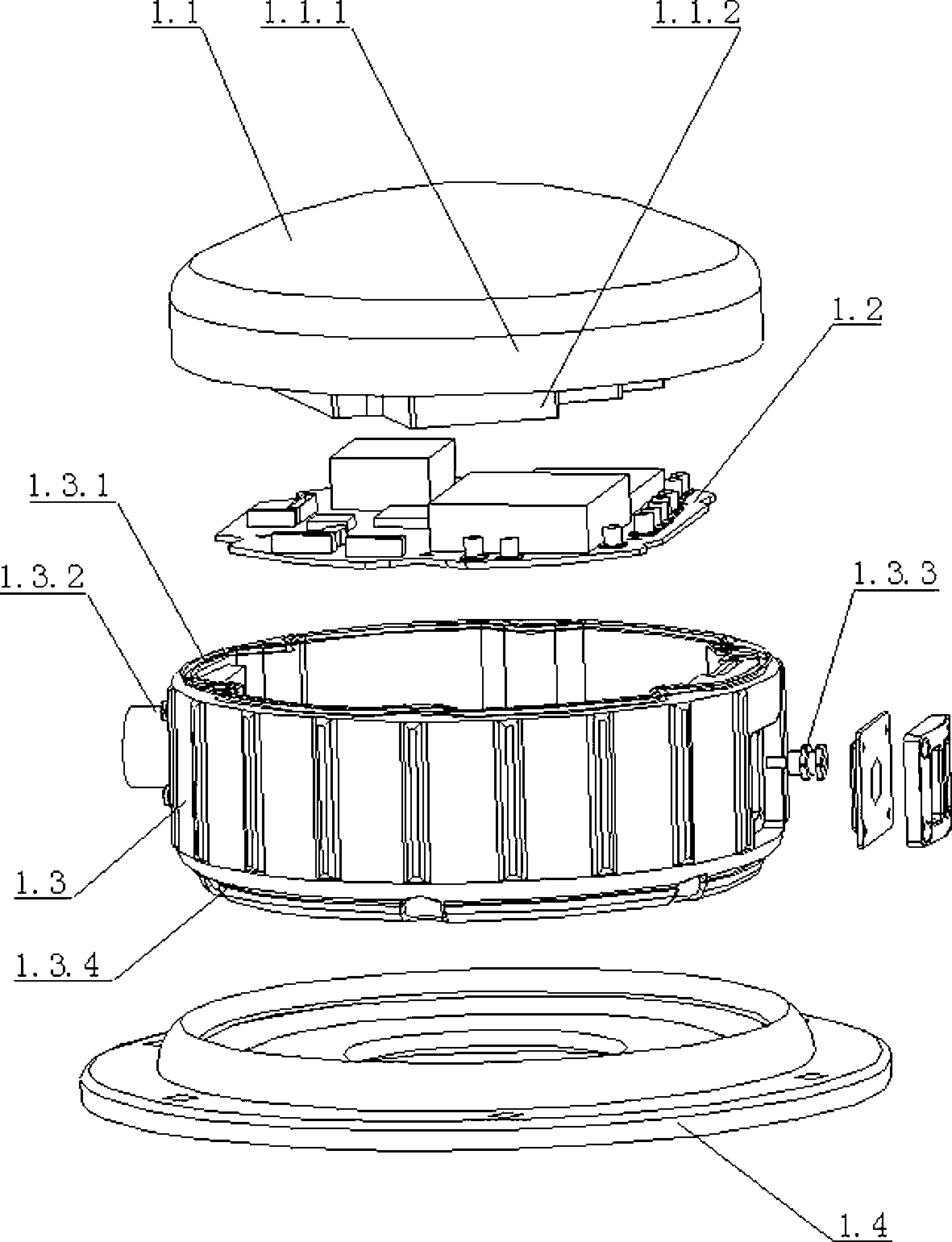
[0054]The present invention is composed of an outdoor unit 1, an indoor unit 2 and a cable 3, wherein: the indoor unit 2 is a man-machine interaction interface, and the outdoor unit 1 includes an antenna module 1.1, an integrated service processing module 1.2, a housing 1.3, and a mounting flange 1.4. In addition, the antenna module 1.1 is placed above the housing, the integrated service processing module 1.2 is placed in the housing 1.3, the mounting flange 1.4 is placed below the housing 1.3, and the 4 are combined from top to bottom to form a whole. The cable 3 is connected with the indoor unit 1 to form the whole system.

[0055] from Figure 4 As can be seen:

[0056] The integrated service processing module 1.2 is a modular structure, including: ARM embedded processor 1.2.1, synchronous dynamic data memory SDRAM 1.2.2, eras...


PUM


Abstract

The invention relates to a tri-mode positioning and navigation system based on BD-1 (Beidou-1)/BD-2 (Beidou-2)/GPS (global position system). The system comprises an outdoor unit, an indoor unit and cables, wherein the indoor unit is a human-computer interaction interface, and the outdoor unit comprises an antenna module, an integrated service management module, a shell and a mounting flange. The antenna module is arranged above the shell, the integrated service management module is arranged inside the shell, the mounting flange is disposed under the shell, and the four portions are combined mutually into a whole from top to bottom. When in work, the outdoor unit respectively receives signals of the BD-1/BD-2/GPS, simultaneously transmits the signals emitted from the BD-1, and completes the functions of radio frequency management, AD (analog-digital) conversion, baseband processing and positioning resolve, and then sends a result to the indoor unit to achieve a human-computer interaction.

Description

technical field [0001] The invention relates to a positioning and navigation system, in particular to a positioning and navigation system based on Beidou-1 / Beidou-2 / GPS three modes. Background technique [0002] Since its inception, GPS has fully demonstrated its dominance in the field of navigation and positioning, and many fields have undergone revolutionary changes due to the emergence of GPS. [0003] Although the GPS satellite navigation and positioning system of the United States can cover the whole world and realize all-weather and all-day navigation, they are all controlled by foreign military forces, and GPS provides positioning services with different accuracy for different levels of users. In areas of military conflict, the United States may turn off GPS in some areas out of consideration of its own interests. Therefore, despite the huge capital required for development and the long cycle, my country is still actively developing its own satellite positioning syst...

Claims


Application Information

Patent Timeline
IPC IPC(8): G01S19/48
Inventor 马立班吴瑞军宋献忠王红梅陈兆辉杨兵红张罡李敏敏李龙概明伶俐周建军饶郁许娟马翼川王红霞
Owner 武汉中元通信股份有限公司
Why Eureka
Try Eureka