System and method with which real-time map is capable of being displayed and shared in mobile terminal

A mobile terminal and mobile smart terminal technology, applied in the field of mutual sharing of real-time geographic location information, can solve problems such as inability to complete location information, user inconvenience, and complexity

Inactive Publication Date: 2013-04-24
青岛联合汇信科技有限公司
View PDF3 Cites 20 Cited by
  • Summary
  • Abstract
  • Description
  • Claims
  • Application Information

AI Technical Summary

Problems solved by technology

[0003] However, the existing map engines or map display programs based on mobile terminals (mobile phones, pads, laptops) are often very complicated, and the requirements for mobile phone hardware are relatively high, and the sharing of real-time geographic location information between friends is not in

Method used


Image

  • System and method with which real-time map is capable of being displayed and shared in mobile terminal

Examples


Embodiment 1

[0032] The system for displaying and sharing real-time maps on a mobile terminal of the present invention includes a service terminal and at least one mobile smart terminal, and the service terminal and the mobile smart terminal are interconnected through a network, wherein the service terminal includes a transceiver module, a map module, a cutting module, and the mobile smart terminal It includes a GPS positioning module, a map control module, a map display module, and a transceiver module; the transceiver module is used to receive and send information; the map module is used for loading and storing maps, receiving and processing GPS map positioning information from smart terminals; The cutting module is used to cut the vector map of unit area size; the map control module is used to send the longitude, latitude and height information located by GPS to the service terminal, and request to download the vector map; the map display module is used to download the downloaded map and ...

Embodiment 2

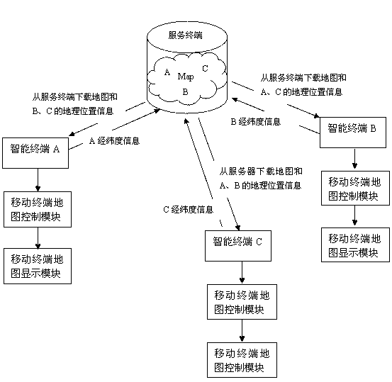
[0040] The difference between this embodiment and Embodiment 1 is that this embodiment is a shared real-time map display, that is, a multi-user operating system, which includes the following steps:

[0041] A: User A selects a shared contact and sends the shared contact information to the service terminal;

[0042] B: The service terminal will send the vector map sent to user A to the mobile smart terminal that shares contacts;

[0043] C: The service terminal receives the geographic location information of the shared contacts at the same time, calculates the scale of the map according to the relative location, and displays the real-time geographic locations and corresponding vector maps of all shared people on each person's mobile smart terminal in real time, and obtains them in real time The latest geolocation information and is updated at regular intervals.

[0044] When sharing a real-time map, the method of sending the real-time geographic location and the corresponding ...

Embodiment 3

[0046] The difference between the present embodiment and embodiment 2 is that the sending mode of the present embodiment is a short message mode, which includes the following steps:

[0047] A: A smart terminal user selects a non-smart terminal user as a shared contact, and sends the shared contact information to the service terminal;

[0048]B: The service terminal generates a URL connection according to the latitude, longitude and altitude information of user A, such as: http: / / map.com / ?x=36.105753&y=120.397904&z=159&m=2, where x is longitude 36.105753 and y is latitude 120.397904 , z is the height of 159 meters, m is the display mode 2D or 3D, and the URL link is sent to the shared contact in the form of a text message;

[0049] C: After the shared contact opens the URL connection in the short message, the browser program is called to display the vector map of user A downloaded through the service terminal in the form of web or wap;

[0050] D: The service terminal receive...


PUM


Abstract

The invention relates to a system and a method with which a real-time map is capable of being displayed and shared in a mobile terminal, and particularly relates to a system and a method with which real-time geographical location information is mutually shared, wherein the system and the method with which the real-time geographical location information is mutually shared are embedded in a mobile terminal. The system and the method with which the real-time geographical location information is mutually shared have the advantages that the system and the method with which the real-time map is capable of being displayed and shared in the mobile terminal are provided, and real-time geographical location information share can be achieved among a plurality of users. The system and the method with which the real-time map is capable of being displayed and shared in the mobile terminal comprise a service terminal and at least one mobile intelligent terminal , wherein the service terminal is connected with the mobile intelligent terminal through a network, the service terminal comprises a transceiver module, a map module and a cutting module, and the mobile intelligent terminal comprises a global position system (GPS) positioning module, a map control module, a map display module and a transceiver module. According to the system and the method with which the real-time map is capable of being displayed and shared in the mobile terminal, the vector map of location can be displayed in the customer mobile intelligent terminal, the vector map of location can be shared with sharers, and the system and the method with which the real-time map is capable of being displayed and shared in the mobile terminal are not affected by phone models and functions as long as the mobile phone has GPS function.

Description

technical field [0001] The present invention relates to a system and method for displaying and sharing a real-time map on a mobile terminal, in particular, to a system and method for sharing real-time geographic location information embedded in a mobile terminal. Background technique [0002] In modern society, whether it is daily life or business negotiations, mobile phones are inseparable. Mobile phones have become an indispensable tool in people's lives. With the continuous development of science and technology, various smart phones are gradually favored by people. Among the various information services that smartphones can provide, GIS has been integrated into the mainstream of information technology and has become an important part of the development of mobile Internet. Geographic information systems also differentiate into location-based services (LBS). LBS uses GPS to display its location with mobile devices through the relationship between the location and the fixed...

Claims


Application Information

Patent Timeline
IPC IPC(8): H04M1/725H04L29/08H04W4/02H04M1/72409
Inventor 鲍桂乾王广银周博
Owner 青岛联合汇信科技有限公司
Why Eureka
Try Eureka