Assisting image matching method by means of airborne lidar point cloud data

A technology of point cloud data and auxiliary images, applied in image data processing, image analysis, instruments, etc., can solve problems such as tedious search problems, and achieve the effect of time-consuming efficiency, high matching success rate, and avoiding search strategies.

Inactive Publication Date: 2013-05-08
THE PLA INFORMATION ENG UNIV
View PDF1 Cites 19 Cited by
  • Summary
  • Abstract
  • Description
  • Claims
  • Application Information

AI Technical Summary

Problems solved by technology

[0004] The purpose of the present invention is to provide a method of using airborne LiDAR point cloud data to assist image matching, so as to solve the cumbersome search problem in the existing image matching methods

Method used


Image

  • Assisting image matching method by means of airborne lidar point cloud data
  • Assisting image matching method by means of airborne lidar point cloud data
  • Assisting image matching method by means of airborne lidar point cloud data

Examples


Embodiment Construction
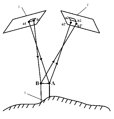
[0032] The basic idea of ​​the method of using airborne LiDAR point cloud data to assist image matching is as follows: figure 1 As shown, 1 is the reference image, 2 is the search image, and 3 is the digital surface model (DSM). First, the feature points are extracted from the reference image as points to be matched, and the DSM corresponding to the overlapping area of ​​the image is generated by using the LiDAR point cloud data. The POS data is converted into the outer orientation elements of the CCD image, combined with the outer orientation elements of the reference image, the ground point coordinates corresponding to each feature point to be matched are calculated according to the principle of single-chip mapping, and then combined with the outer orientation elements of the search image and according to the ground The collinear relationship between the point and the image point on the search image is obtained to obtain the initial position of the point to be matched on the ...


PUM


Abstract

The invention relates to an assisting image matching method by means of airborne lidar point cloud data. The assisting image matching method by means of the airborne lidar point cloud data includes the steps of obtaining a reference image, searching image and the cut out airborne lidar point cloud data, abstracting a feature point from the reference image as a point to be matched, generating regularized digital surface model (DSM) information corresponding to an image overlapped region by means of the lidar point cloud data, converting point of sale (POS) data into elements of exterior orientation of the reference image, working out object space coordinates of corresponding ground points of the feature point to be matched by means of the DMS information and the elements of exterior orientation of the reference image, reversely calculating object space coordinates of the corresponding ground points to the searching image, obtaining the initial position of a corresponding matching point of the searching image, and matching by means of the correlation index to obtain a final matching result. The assisting image matching method provides good object space restraint for image matching by means of the lidar point cloud data, can effectively avoid complicated search strategies, achieves the purpose of the image matching and is high in matching success rate, short in consumed time and effective.

Description

technical field [0001] The invention belongs to the field of photogrammetry and remote sensing, and relates to remote sensing image matching and airborne laser radar LiDAR measurement technology, in particular to a method for using airborne LiDAR point cloud data to assist image matching. Background technique [0002] Remote sensing image matching is a hot and difficult problem in the field of photogrammetry research. It is widely used in the relative orientation of stereo pairs, remote sensing image registration, DEM (digital elevation model) generation and remote sensing image stitching. It is defined as the automatic establishment of correspondence between the elements of two or more digital images, which are acquired at different locations and at different times for the same scene, and the elements can be points in the digital image, or other features extracted . Existing matching methods must use cumbersome search strategies to obtain the corresponding matching points ...

Claims


Application Information

Patent Timeline
Patent Type & Authority Applications(China)
IPC IPC(8): G06T7/00
Inventor 王慧李鹏程张勇王利勇闸旋李烁刘忠滨武海洋胡志定
Owner THE PLA INFORMATION ENG UNIV
Why Eureka
Try Eureka