Space-borne synthetic aperture interferometer radar image registration method with use of feature point Voronoi diagram optimization

A synthetic aperture and interferometric radar technology, applied in image analysis, image data processing, instruments, etc., can solve the problem of uneven distribution of feature points with the same name

Active Publication Date: 2014-06-25
CHINESE ACAD OF SURVEYING & MAPPING
View PDF2 Cites 7 Cited by
  • Summary
  • Abstract
  • Description
  • Claims
  • Application Information

AI Technical Summary

Problems solved by technology

[0005] The purpose of the present invention is to solve the deficiencies of the existing synthetic aperture radar image registration method, and propose a complex image registration method based on Forstner feature point extraction and Voronoi diagram feature point optimization, which overcomes the problem of using the regular grid center point as a feature The randomness and blindness of searching for feature points with the same name, the uneven distribution of feature points with the same name caused by the feature point weight selection algorithm, and the shortcomings of repeated redundant calculations based on the pyramid-based multi-level matching strategy algorithm

Method used


Image

  • Space-borne synthetic aperture interferometer radar image registration method with use of feature point Voronoi diagram optimization
  • Space-borne synthetic aperture interferometer radar image registration method with use of feature point Voronoi diagram optimization
  • Space-borne synthetic aperture interferometer radar image registration method with use of feature point Voronoi diagram optimization

Examples


Embodiment Construction

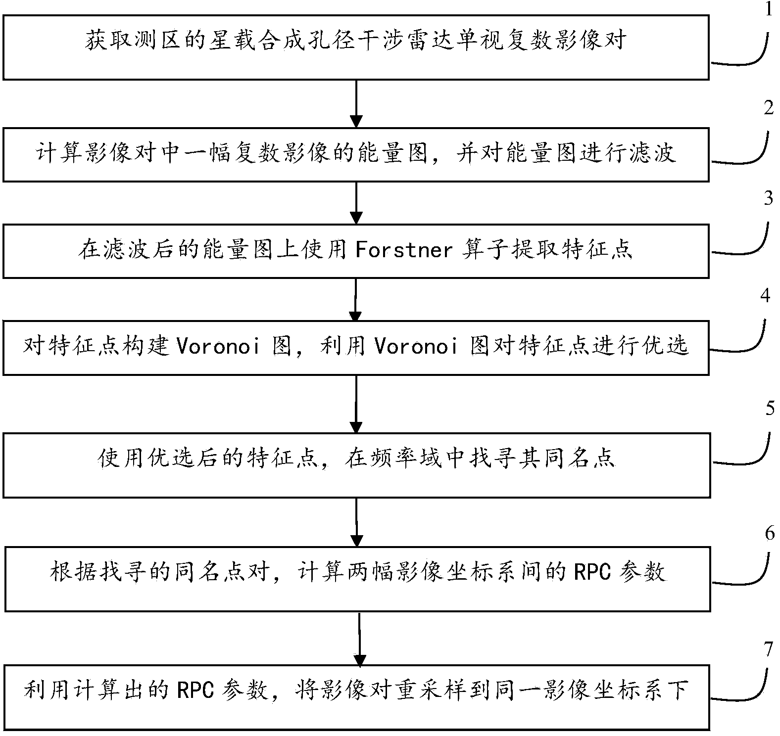
[0058] The present invention will be described in further detail below in conjunction with the accompanying drawings.

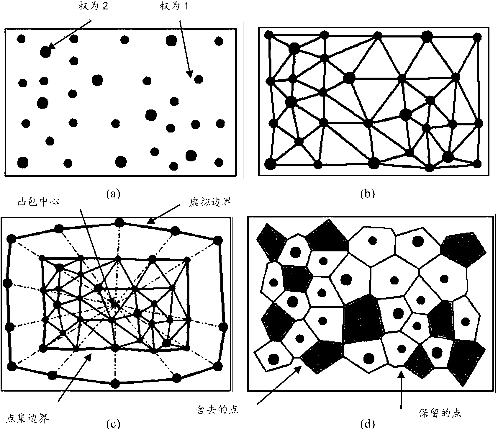
[0059] This spaceborne synthetic aperture radar image registration method, through the Forstner operator extraction of feature points, Voronoi map optimization, can make full use of the significance and high coherence of feature points in the survey area, and consider the influence of feature point distribution The influence of images on geometric relationship fitting can obtain a higher success rate of feature point matching, increase the value of interference coherence coefficient, and then improve the accuracy of image registration.

[0060] First, one of the interferometric image pairs acquired by the same spaceborne interferometric radar sensor over two passes of the same area, or two complex images acquired by two different spaceborne interferometric radar sensors in a single visit to the same area, is selected. One image is the master image, and the ot...


PUM


Abstract

The invention relates to a space-borne synthetic aperture interferometer radar image registration method with feature point Voronoi diagram optimization. The method is mainly characterized in that the deployment strategy of a matching reference point is novel, the attribute information of statistical information, thematic information, topological information, metric information and the like of a feature point is fully considered. The method comprises the steps of (1) obtaining the space-borne InSAR complex image pair of a measured area, (2) calculating the energy image of one complex image in the image pair and carrying out filtering processing, (3) using a Forstner operator to extract a feature point in the filtered energy image, (4) constructing a Voronoi diagram for the extracted feature point and optimizing the feature point by using the Voronoi diagram, (5) using the optimized feature point and adopting a method related to maximum spectrum to search a same name point, (6) calculating a model parameter between two images according to the searched same name point pair, and (7) unifying the two images in the same image coordinate system by using the calculated model parameter. According to the method, the same name point search success rate and related coefficient value are raised, thus the optimized feature point is more reasonable in the distribution, the calculation precision of the model coefficient is raised, and thus the registration precision of the image pair is raised.

Description

technical field [0001] The invention belongs to the field of synthetic aperture radar interferometric measurement of remote sensing images, in particular to a terrain deformation monitoring and three-dimensional reconstruction method of spaceborne synthetic aperture interferometric radar remote sensing images. Background technique [0002] Spaceborne synthetic aperture interferometric radar uses a single radar satellite to revisit the same area twice, or multiple radar satellites fly in formation to obtain two complex images (including intensity information and phase information) of a certain area. The phase difference between the images contains the deformation information and three-dimensional position information of the ground target. Spaceborne synthetic aperture interferometric radar image registration refers to the technology and method to make the same resolution unit (ie pixel) in the image alignment correspond to the same echo point unit on the ground through certai...

Claims


Application Information

Patent Timeline
Patent Type & Authority Applications(China)
IPC IPC(8): G06T7/00
Inventor 张继贤王邦松黄国满卢丽君段敏燕
Owner CHINESE ACAD OF SURVEYING & MAPPING
Why Eureka
Try Eureka