Road condition event information providing method, device and guided system

A technology of event information and road conditions, applied in the field of navigation, to achieve the effect of improving navigation efficiency, enhancing practicability, and improving accuracy

Active Publication Date: 2013-06-05
SHANGHAI PATEO ELECTRONIC EQUIPMENT MANUFACTURING CO LTD
View PDF4 Cites 15 Cited by
  • Summary
  • Abstract
  • Description
  • Claims
  • Application Information

AI Technical Summary

Problems solved by technology

[0006] The invention solves the problem of driving efficiency caused by the absence of

Method used


Image

  • Road condition event information providing method, device and guided system
  • Road condition event information providing method, device and guided system

Examples


Embodiment Construction

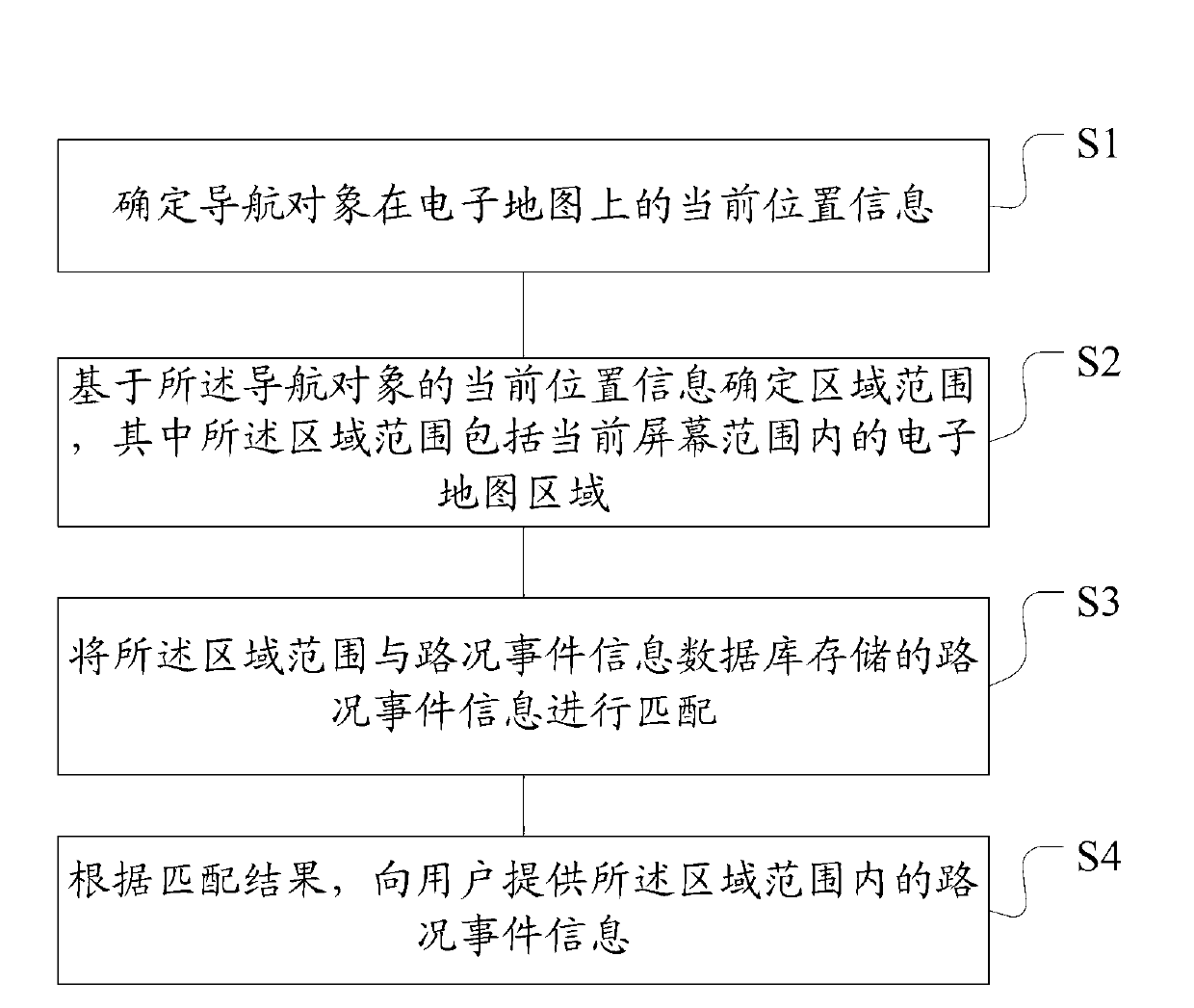
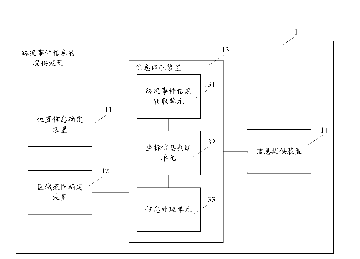
[0022] Aiming at the problems in the prior art, the inventor provides a method and device for providing road condition event information, and a navigation system after research. Through this technical solution, the navigation system can actively match the traffic event information stored in the traffic event information database with the determined area range, and provide the user with traffic event information within the area range according to the matching result, where the area range can be The electronic map area covering the current screen range. Furthermore, the current location of the navigation object and the driving direction of the navigation route can also be combined to determine the area range, which not only includes the range of each road segment on the navigation route, but also covers the surrounding area of ​​the navigation route, and effectively reduces the The coordinate position of the road condition event information delivered by the network end may be af...


PUM


Abstract

Disclosed are a road condition event information providing method, a device and a guided system. The road condition event information providing method comprises the following steps: confirming current position information of a guided object in an electronic map; confirming an area scope on the basis of the current position information of the guided object, wherein the area scope comprises an electronic map area within the scope of a current screen; and matching the area scope with road condition event information stored in a road condition event information data bank; providing the road condition event information within the scope of the area for a user according to a matching result. According to the technical scheme, the guided system can automatically match the road condition event information stored in the road condition event information data bank with the confirmed area scope, and providing the road condition event information within the scope of the area for the user according to the matching result, so that guiding efficiency of the guided system is improved.

Description

technical field [0001] The invention relates to the technical field of navigation, in particular to a method and device for providing road condition event information, and a navigation system. Background technique [0002] Navigation systems based on the Global Positioning System (GPS) are widely used in the automotive field to provide drivers with navigation routes. Usually, the functions of the navigation system include providing a map database to enable the display of the navigation system to display an electronic map, and obtaining the location of the car through a GPS receiver. During the driving process of the car, the navigation system will calculate the route according to the destination information and departure information input by the user and generate a navigation route, or the navigation system can also calculate the route through the remote server connected to it, and the remote server will provide corresponding information after calculating the route. Navigat...

Claims


Application Information

Patent Timeline
IPC IPC(8): G08G1/0967G08G1/0969G01C21/34
Inventor 鹿培信
Owner SHANGHAI PATEO ELECTRONIC EQUIPMENT MANUFACTURING CO LTD
Why Eureka
Try Eureka