Road condition video navigation system and method

A technology of a navigation system and a navigation method, which is applied in the field of navigation systems, can solve problems such as the difficulty for drivers to correspond to buildings and the inability of the navigation system to update the database in time, and achieve the effects of simplifying the cumbersome use, reducing driving accidents, and improving navigation efficiency

Inactive Publication Date: 2016-02-17
SHENZHEN RUGUO TECH
View PDF17 Cites 14 Cited by
  • Summary
  • Abstract
  • Description
  • Claims
  • Application Information

AI Technical Summary

Problems solved by technology

[0004] The picture of the navigation system is generally a static, two-dimensional display, and it is difficult for the driver to correspond to the real buildings on both sides of the road through the surrounding environment indicated by the navigation road signs.
[0005] In some remote areas, it is necessary to manually identify the direction of the destination, and in some areas where urban construction is updated rapidly, the navigation system still cannot update the database in time to guide the driver correctly

Method used


Image

  • Road condition video navigation system and method
  • Road condition video navigation system and method
  • Road condition video navigation system and method

Examples


Embodiment 1

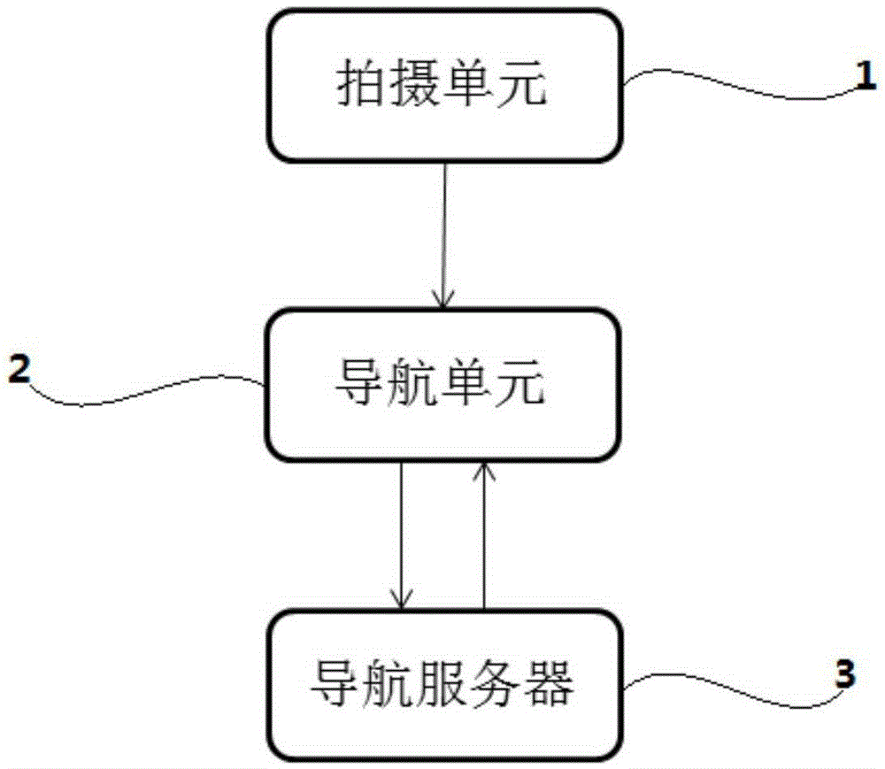
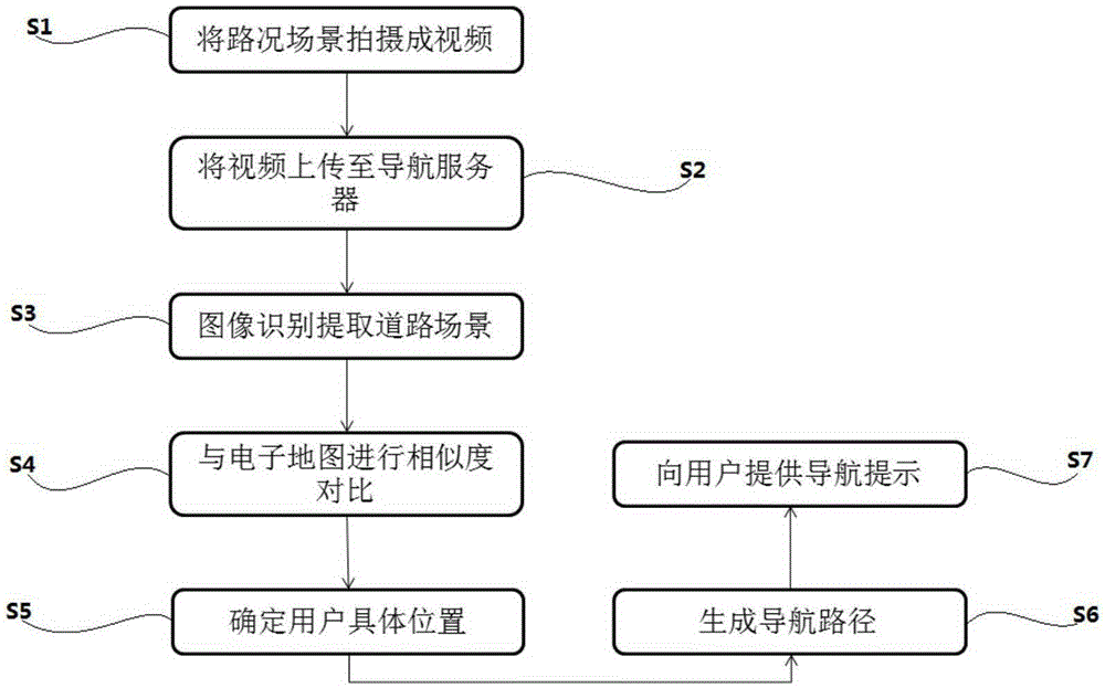
[0040] Such as figure 1 As shown, a traffic video navigation system includes: a shooting unit 1 , a navigation unit 2 and a navigation server 3 . The photographing unit 1 is used for photographing the scene around the current road as video information. The navigation unit 2 is used to store the video information captured by the shooting unit 1, send identification information to the navigation server 3, and receive the navigation prompt information returned by the navigation server 3, so as to provide accurate navigation prompts for the user. The navigation server 3 is configured to receive the identification information sent by the navigation unit 2 , determine accurate navigation prompt information according to the identification information, and return the navigation prompt information to the navigation unit 2 . The identification information includes: destination coordinates and video information shot by the shooting unit 1 . The navigation server 3 stores an electronic ...

Embodiment 2

[0056] A road condition video navigation system based on an intelligent mobile terminal, comprising: a shooting unit 1 , a navigation unit 2 and a navigation server 3 . Wherein the shooting unit 1 is a camera integrated in the smart mobile terminal, the navigation unit 2 is a touch display screen and a voice device integrated in the smart mobile terminal, the navigation server 3 is a CPU and a storage device integrated in the smart mobile terminal, and an electronic map is stored in the smart mobile terminal , the CPU uses image recognition technology to extract the scene in the real-time traffic video captured by the camera, compares the scene with the electronic map, determines the user's current location, and forms a navigation path between the current location and the destination coordinates. The current location and navigation path generate navigation prompt information.

[0057] In some embodiments, the CPU locates the user coordinates by integrating the GPS device at th...


PUM


Abstract

The invention is used for shooting a road condition scene in a driving process into a video; the road condition scene shot in the video is extracted through an image identification technology and a similarity comparison technology; the road condition scene and a pre-stored electronic map are subjected to similarity comparison; when one point in the road condition scene has the highest similarity as a certain point in the electronic map, the point is a current position of a user; a navigation path is generated according to the current position of the user and a destination coordinate; a navigation prompt is provided for the user according to the navigation path. By adopting a video navigation technology, the problem that the utilization of traditional GPS (Global Position System) navigation is relatively complicated is greatly simplified and the efficiency of identifying the direction in a driving process is improved; when the user uses the video navigation, the user only needs to input the destination, so that the user can conveniently utilize the video navigation and the driving accidents are effectively reduced.

Description

technical field [0001] The invention relates to a navigation system, in particular to a traffic video navigation system. Background technique [0002] Along with the development of economy, people's living standards have been universally improved, and the popularization of automobiles has penetrated more and more into people's daily travel, and automobiles are used as the main means of transportation when going out. Automobiles have expanded people's living range from the traditional 10 kilometers to 100 kilometers. As the driving distance increases, people's familiarity with the surrounding environment and road conditions will become more and more unfamiliar. On some unfamiliar road sections, as long as the driver enters the destination into the car navigation system, the system will automatically calculate the most suitable route according to the electronic map, and remind the driver to follow the calculated route while the vehicle is driving (for example, before turning)....

Claims


Application Information

Patent Timeline
Patent Type & Authority Applications(China)
IPC IPC(8): G01C21/32G01C21/36
CPCG01C21/32G01C21/3647
Inventor 刘毅刘芳黄文英
Owner SHENZHEN RUGUO TECH
Why Eureka
Try Eureka