
A gis spatial simulation method for wetland landscape near-surface cold and wet climate elements based on remote sensing data

A cold and wet climate and wetland landscape technology, applied in the direction of electrical digital data processing, special data processing applications, instruments, etc., can solve the problem of not being able to obtain high-precision air temperature spatial distribution, improve the effect of spatial simulation, increase the amount of total information, Effect of Radiation Resolution Improvement

Inactive Publication Date: 2016-11-30
NORTHEAST INST OF GEOGRAPHY & AGRIECOLOGY C A S
View PDF2 Cites 0 Cited by
  • Summary
  • Abstract
  • Description
  • Claims
  • Application Information

AI Technical Summary

Problems solved by technology

[0004] In order to solve the problem that the existing spatial interpolation method cannot obtain high-precision air temperature spatial distribution, the present invention provides a GIS spatial simulation method based on remote sensing data for wetland landscape near-surface cold and wet climate elements

Method used


Image

  • A gis spatial simulation method for wetland landscape near-surface cold and wet climate elements based on remote sensing data
  • A gis spatial simulation method for wetland landscape near-surface cold and wet climate elements based on remote sensing data
  • A gis spatial simulation method for wetland landscape near-surface cold and wet climate elements based on remote sensing data

Examples


specific Embodiment approach 1

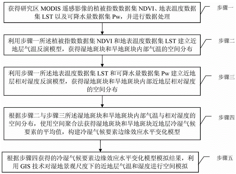
[0049] Specific implementation mode one, combination Figure 1-Figure 8 Explain that this embodiment is a GIS spatial simulation method of wetland landscape near-surface cold and wet climate elements based on remote sensing data, which includes the following steps:

[0050] Step 1: Obtain the vegetation index data set NDVI, land surface temperature data set LST, and precipitation data set Pw of MODIS remote sensing images in the study area, and perform data processing;

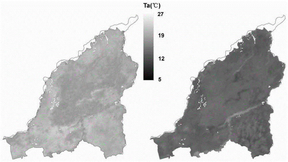
[0051] Step 2: Use the vegetation index data set NDVI and the land surface temperature data set LST described in Step 1 to establish a near-surface temperature inversion model to obtain the spatial distribution of internal temperature in wetland patches and dryland patches;

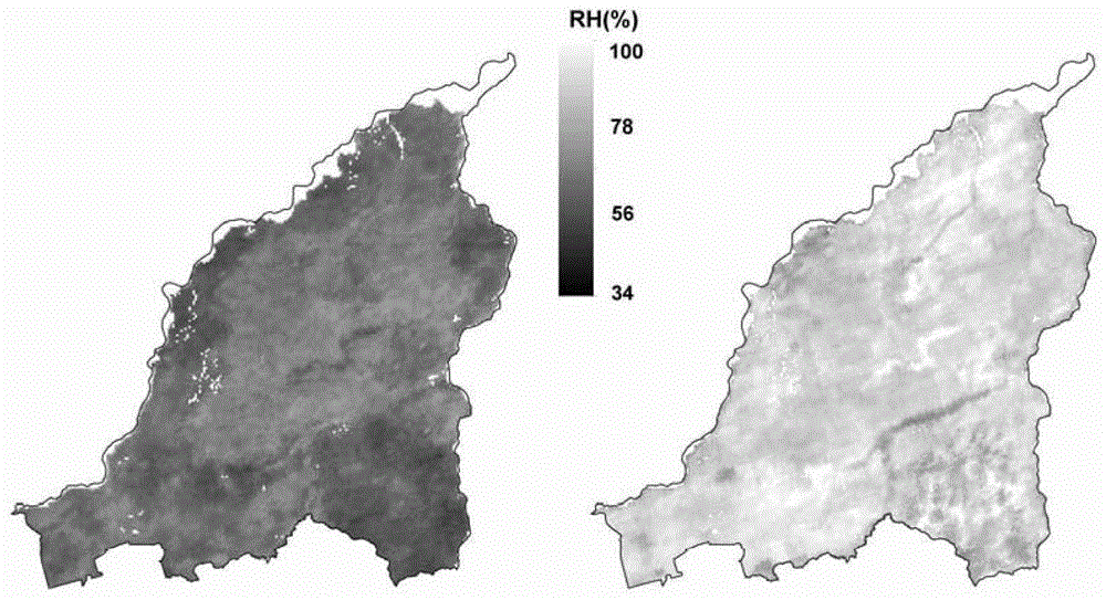
[0052] Step 3: Use the surface temperature data set LST and the precipitation data set Pw described in Step 1 to establish a near-surface relative humidity inversion model to obtain the spatial distribution of the near-surface relative humidity i...

specific Embodiment

[0094] Step 1: Obtain the 16-day vegetation index data set NDVI, 8-day land surface temperature data set LST, and daily precipitation data of MODIS (Moderate-resolution Imaging Spectroradiometer,) from the United States Geological Survey (USGG) website Collect Pw and perform data processing;

[0095] Use MRT and HEG software to perform image stitching and projection conversion of all MODIS HDF files, select Albers projection, reference ellipsoid is WGS84, and perform radiometric calibration for a set of study areas;

[0096] Obtain the spatial distribution of water bodies through land use data, perform water body masking on the vegetation index data set NDVI, land surface temperature data set LST, and precipitable data set Pw, and remove abnormal and invalid values; then, perform cloud processing to eliminate Outliers and invalid values ​​affected by the cloud.

[0097] At 8 day intervals, the morning near-infrared and infrared data of the daily precipitation data set are superimpos...


PUM


Abstract

A GIS spatial simulation method for wetland landscape near-surface cold and wet climate elements based on remote sensing data, involving a remote sensing data-based wetland management and near-surface cold and wet climate spatial simulation method, in order to solve the problem that existing spatial interpolation methods cannot obtain high-precision air temperature spatial distribution. Obtain vegetation index data set NDVI, surface temperature data set LST and precipitable precipitation data set Pw of MODIS remote sensing image in the study area; Spatial distribution of relative humidity; use the spatial aggregation method to obtain the average value of cold and wet climate elements in wetland patches and dryland patches near the surface layer, and construct a model of edge effect level change of cold and wet climate elements; use GIS technology to analyze the near-surface layer at the scale of wetland landscape Air temperature and humidity are simulated spatially. The invention can be widely used in spatial simulation of wetland landscape climate.

Description

Technical field [0001] The invention relates to a method for simulating the cold and wet climate near the ground in a wetland landscape based on remote sensing data. Background technique [0002] In the face of global environmental changes in recent decades, the problem of regional wetland landscape changes under the disturbance of human activities has become an important content of global change research, especially the research on wetland landscape changes and the climate effects brought by them has become a research hotspot and coordinated wetland protection And the basis for the sustainable development of the regional economy. Therefore, accurate acquisition of the spatial distribution of cold and wet climate elements plays a very important role in the study of wetland ecosystem regional climate models, hydrological and ecological models, and global climate response. [0003] At present, obtaining meteorological data from meteorological station observations is one of the main ...

Claims


Application Information

Patent Timeline
Patent Type & Authority Patents(China)
IPC IPC(8): G06F19/00
Inventor 廖晓玉刘兆礼
Owner NORTHEAST INST OF GEOGRAPHY & AGRIECOLOGY C A S
Learn More