WebGIS three-dimensional lunar system based on ActiveX and realizing method of WebGIS three-dimensional lunar system

A GIS server, lunar technology, used in special data processing applications, instruments, electrical digital data processing, etc.

Active Publication Date: 2013-09-04
NAT ASTRONOMICAL OBSERVATORIES CHINESE ACAD OF SCI +1
View PDF2 Cites 20 Cited by
  • Summary
  • Abstract
  • Description
  • Claims
  • Application Information

AI Technical Summary

Problems solved by technology

Although 3D software such as GoogleEarth and Google Moon realize the display of 3D Earth and 3D Moon based on

Method used


Image

  • WebGIS three-dimensional lunar system based on ActiveX and realizing method of WebGIS three-dimensional lunar system
  • WebGIS three-dimensional lunar system based on ActiveX and realizing method of WebGIS three-dimensional lunar system

Examples


Embodiment Construction

[0025] In order to make the object, technical solution and advantages of the present invention clearer, the present invention will be described in further detail below in conjunction with specific embodiments and with reference to the accompanying drawings.

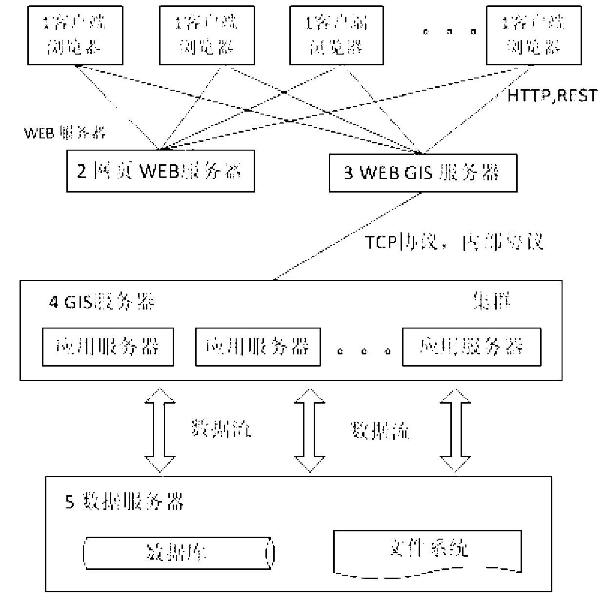
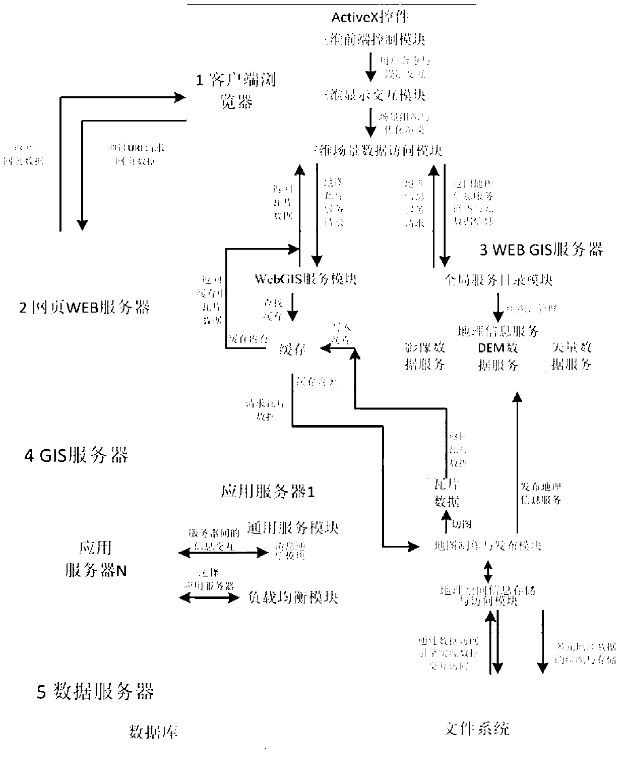
[0026] The invention proposes a three-dimensional visualization system of the moon based on WebGIS. The system displays a 3D moon on the Web, and the technical difficulties mainly focus on the following three aspects: First, how to display the 3D scene and draw the 3D model on the browser. Second, how to transmit the huge lunar data from the server to the client. Third, how the server organizes and manages geographic information data and can accept client requests and return responses.

[0027] The present invention proposes a WebGIS three-dimensional lunar system based on ActiveX. The system is mainly composed of client browser, webpage WEB server, WebGIS server, GIS server cluster and data server. Information is realiz...


PUM


Abstract

The invention discloses a WebGIS three-dimensional lunar system based on ActiveX. The WebGIS three-dimensional lunar system based on the ActiveX is characterized in that the system comprises a client-side browser, a webpage WEB server, a WebGIS server, a GIS server cluster and a data server, the client-side browser is used for data displaying, data acquiring and data cache, providing an interactive interface, drawing a three-dimensional model and inserting a three-dimensional scene into the browser by means of the ActiveX control technology, the webpage WEB server is used for responding to page requests sent by the client-side browser and feeding back a page response to the client of the browser, the WebGIS server is used for providing service catalogues and tile services for the client of the browser, the GIS server cluster is used for providing underlying GIS supporting services including universal services, storage and access of geographic space information, manufacturing and releasing of maps and load balancing, and the data server is used for storing geographic information data. According to the WebGIS three-dimensional lunar system based on the ActiveX and a realizing method of the WebGIS three-dimensional lunar system, the three-dimensional lunar scene is inserted into a webpage, namely lunar data are displayed in a three-dimensional mode with the B/S structure, and the three-dimensional lunar scene can be browsed directly by a user through the browser.

Description

technical field [0001] The invention belongs to the field of WebGIS application and image three-dimensional visualization, and in particular relates to a system and an implementation method for displaying lunar data in three-dimensional form on a browser. Background technique [0002] WebGIS is a geographic information system based on the Internet platform, and the client adopts the WWW protocol. With the popularization and deepening of the Internet, WebGIS has become the mainstream direction of GIS technology research. Compared with traditional GIS, the most obvious advantage is that it puts GIS on the Internet, which shows the infinite vitality hidden in GIS. [0003] At present, WebGIS has entered the life of the public unknowingly. It is very popular for people to use maps to find locations and obtain routes on browsers. However, these WebGIS are still on the two-dimensional level, and a three-dimensional GIS is displayed on the Web. It is a new research direction. Alt...

Claims


Application Information

Patent Timeline
IPC IPC(8): G06F17/30
Inventor 左维刘光雷张舟斌邢丽平王向华张锋叶耿良王晓倩张桂花李春来
Owner NAT ASTRONOMICAL OBSERVATORIES CHINESE ACAD OF SCI
Why Eureka
Try Eureka