High-accuracy high-resolution satellite imaging simulation engine and implementation method

An imaging simulation, high-resolution technology, applied in the field of aerospace remote sensing, can solve problems such as single-node performance bottlenecks, and achieve the effects of reducing scalability, improving computing efficiency, and achieving load balance

Inactive Publication Date: 2013-09-04
INST OF SOFTWARE - CHINESE ACAD OF SCI
View PDF3 Cites 15 Cited by
  • Summary
  • Abstract
  • Description
  • Claims
  • Application Information

AI Technical Summary

Problems solved by technology

[0008] The purpose of the present invention is to solve the above problems, provide a high-precision and high-resolution satellite imaging simulation engine and its implementation method, based on ray tracing rendering technology, quickly render large-scale and complex terrain and landform scenes, and solve the problem of single-node performance in data communication Bottleneck problem, achieve load balancing and high scalability between nodes, reduce the time required for satellite imaging simulation, and improve simulation efficiency

Method used


Image

  • High-accuracy high-resolution satellite imaging simulation engine and implementation method
  • High-accuracy high-resolution satellite imaging simulation engine and implementation method
  • High-accuracy high-resolution satellite imaging simulation engine and implementation method

Examples


Embodiment Construction

[0041] The present invention will be further described in detail with reference to the accompanying drawings and embodiments.

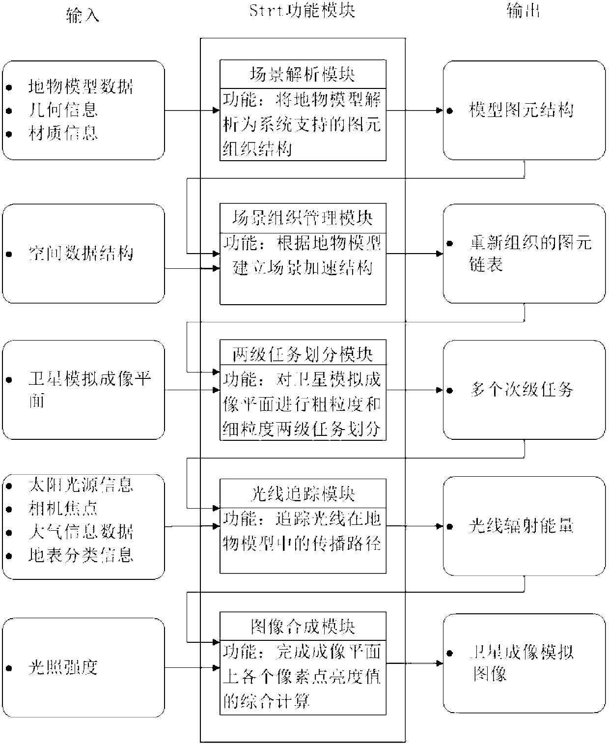
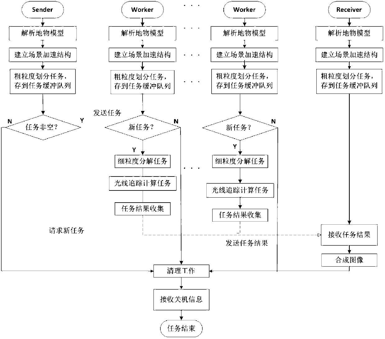
[0042] The object of the present invention is to propose a satellite imaging simulation engine and its implementation method. The ground object model data is resolved into the primitive structure supported by the system through the scene analysis module, and the scene space is divided to establish the scene acceleration structure through the scene organization management module. Through the two-level task division module, the satellite simulation imaging plane is divided into coarse-grained and fine-grained two-level tasks to obtain multiple sub-tasks, and the ray tracing module is used to trace the propagation path of light in the ground object model, according to the ground object classification information and illumination information Determine the reflection, refraction, and scattering of the light source and ambient incident light on the surface o...


PUM


Abstract

The invention relates to a high-accuracy high-resolution satellite imaging simulation engine and an implementation method. The engine comprises a scenario resolving module, a scenario organization and management module, a two-stage task division module, a ray tracing module and an image synthesis module. According to the engine and the implementation method, a large-scale and complex landform scenario can be quickly rendered based on a ray tracing rendering technology by using a Sender-Worker-Receiver parallel calculation model, a two-stage task division method and a dynamic adaptive scheduling method, the problem of single node performance bottlenecks during data communication is solved, load balance and high expansibility between nodes are ensured, time for satellite imaging simulation is shortened, and the simulation efficiency is improved.

Description

technical field [0001] The invention relates to a high-precision and high-resolution satellite imaging simulation engine and a realization method, which are used for simulating high-precision and high-resolution space satellite imaging, and belong to the technical field of spaceflight remote sensing. Background technique [0002] With the development of remote sensing technology and the commercialization of remote sensing satellites in recent years, optical remote sensing imaging simulation technology has gradually replaced the physical simulation technology with small reusability and large construction engineering in the past, and has been generally recognized, and people have begun to pay attention to it. The role of satellite imaging simulation technology in the design, manufacture, assembly, integration, and operation and maintenance of satellites and remote sensors. [0003] Remote sensing satellite is an important part of the space reconnaissance and detection system, ...

Claims


Application Information

Patent Timeline
Patent Type & Authority Applications(China)
IPC IPC(8): G06T15/06
Inventor 张云泉吴长茂杨聪俐
Owner INST OF SOFTWARE - CHINESE ACAD OF SCI
Why Eureka
Try Eureka