Winter wheat area estimation method based on remote-sensing time series data

A time-series data and winter wheat technology, applied in computing, computer components, instruments, etc., can solve problems affecting the reliability of classification results, differences in vegetation index variation curves within a year, and affecting classification accuracy, etc.

Active Publication Date: 2013-10-02
FUZHOU UNIV
View PDF4 Cites 24 Cited by
  • Summary
  • Abstract
  • Description
  • Claims
  • Application Information

AI Technical Summary

Problems solved by technology

This type of method is intuitive and easy to implement, but its disadvantages are: (1) The vegetation index data sets based on MODIS or SPOT remote sensing platform are affected by noise to a certain extent, and the known winter wheat and pending The annual change curve of the sub-pixel is naturally difficult to avoid the interference of noise, which directly affects the classification accuracy; (2) the distance calculation between the unknown pixel and the known winter wheat is directly based on the original change curve of the vegetation index in the year, and differently Due to different farming methods, soil fertility, irrigation conditions, etc., the winter wheat in different plots directly leads to large differences in the annual variation curves of winter wheat vegetation index in different plots. This uncertainty between known samples directly affects the classification results. reliability

Method used


Image

  • Winter wheat area estimation method based on remote-sensing time series data

Examples


Embodiment Construction

[0025] The present invention will be further described below in conjunction with the accompanying drawings and embodiments.

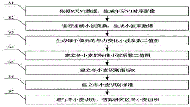
[0026] please join figure 1 , the present embodiment provides a method for estimating winter wheat area based on remote sensing time series data, which is characterized in that it includes the following steps:

[0027] S1. Obtain time-series data of remote sensing vegetation index, and generate an annual time-series data set of vegetation index for each pixel in the study area with daily as the time step;

[0028] S2. Using continuous wavelet transform, the annual time series data of vegetation index of each pixel is converted into wavelet coefficient spectrum;

[0029] S3. Based on the wavelet coefficient spectrum, establish a wavelet coefficient binary map representing the vegetation change characteristics of each pixel year in the research area;

[0030] S4. Superimpose the wavelet coefficient binary images of N known winter wheat sample points, a...


PUM


Abstract

The invention relates to a winter wheat area estimation method based on remote-sensing time series data, which is based on the remote-sensing time series data, and comprises the steps that remote-sensing vegetation index time series data is converted into a wavelet coefficient spectrum by continuous wavelet conversion; wavelet coefficient binary images representing annual vegetation change characteristics of pixels in a study region are established on the basis; the wavelet coefficient binary images of a plurality of known winter wheat sampling points are superposed; standard wavelet coefficient binary images of winter wheat in the study region are generated; the wavelet coefficient binary images of the pixels in the study region and the standard wavelet coefficient binary images of the winter wheat are superposed one by one; winter wheat identification criteria are established after statistic superposition; the pixels are subjected to winter wheat identification one by one; and finally a winter wheat planting area of the whole study region is obtained by summarizing and computing. The method can effectively solve the problems that annual variance amplitude of the original vegetation index is inconsistent due to various factors, and has the advantages of high anti-noise capacity, good classification accuracy, wide application scope and the like.

Description

technical field [0001] The invention belongs to the technical field of remote sensing image information processing, and relates to a winter wheat area estimation method based on remote sensing time series data. Background technique [0002] Wheat is a worldwide food crop. Its output in my country is second only to rice. Its planting area and output are related to the national economy and people's livelihood. At present, the channels for obtaining data on the planting area of ​​winter wheat are mainly agricultural survey sampling statistics and remote sensing monitoring. Compared with traditional agricultural survey sampling methods, remote sensing technology has obvious advantages in obtaining information quickly in a large area. In addition, satellite remote sensing systems such as MODIS can provide daily remote sensing image data covering the whole world, providing a detailed data basis for monitoring crop planting area. How to make full use of the time series informatio...

Claims


Application Information

Patent Timeline
Patent Type & Authority Applications(China)
IPC IPC(8): G06K9/00G06K9/62
Inventor 邱炳文
Owner FUZHOU UNIV
Why Eureka
Try Eureka