External calibration method of satellite-borne interferometric synthetic aperture radar (InSAR) system

An external calibration and space-borne technology, applied to radio wave measurement systems, instruments, etc., can solve the problems of not being able to revisit the calibration field frequently, not being able to image the calibration field, and insufficient sampling, so as to improve the accuracy and reliability of elevation measurement performance, avoid design and implementation difficulties, and avoid the effect of insufficient sampling

Active Publication Date: 2015-02-04
INST OF ELECTRONICS CHINESE ACAD OF SCI
View PDF1 Cites 2 Cited by
  • Summary
  • Abstract
  • Description
  • Claims
  • Application Information

AI Technical Summary

Problems solved by technology

[0006] It is difficult and costly to lay out artificial point target calibration fields in areas with complex terrain, and the calibration field cannot be imaged frequently. It can only statically calibrate the fixed error of the system, and it is difficult to accurately reflect the changing characteristics of the error; the natural distribution target calibration field also has problems Frequently revisit the calibration field, unable to continuously monitor the spaceborne InSAR system for a long time, resulting in insufficient sampling, and unable to reflect the slowly changing part of the InSAR system error

Method used


Image

  • External calibration method of satellite-borne interferometric synthetic aperture radar (InSAR) system
  • External calibration method of satellite-borne interferometric synthetic aperture radar (InSAR) system
  • External calibration method of satellite-borne interferometric synthetic aperture radar (InSAR) system

Examples


Embodiment Construction

[0025] In order to make the object, technical solution and advantages of the present invention clearer, the present invention will be described in further detail below in conjunction with specific embodiments and with reference to the accompanying drawings.

[0026] It should be noted that, in the drawings or descriptions of the specification, similar or identical parts all use the same figure numbers. Steps or implementations not shown or described in the accompanying drawings are forms known to those of ordinary skill in the art. Additionally, while illustrations of parameters including particular values ​​may be provided herein, it should be understood that the parameters need not be exactly equal to the corresponding values, but rather may approximate the corresponding values ​​within acceptable error margins or design constraints.

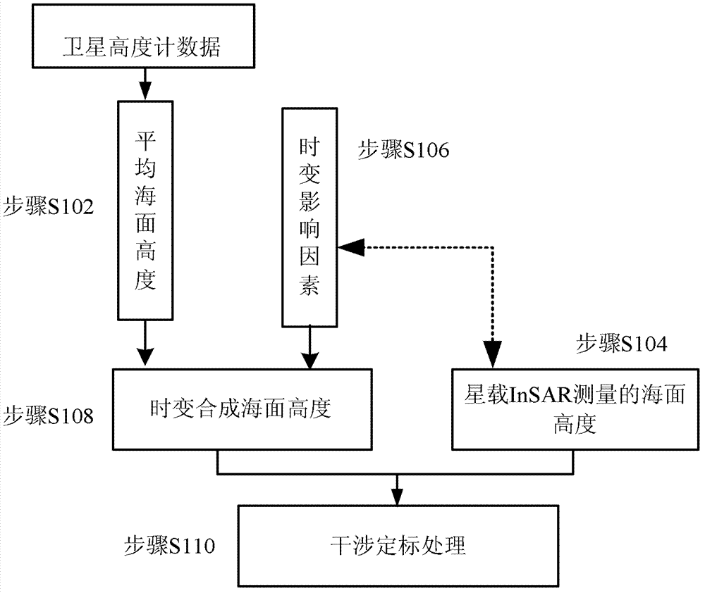
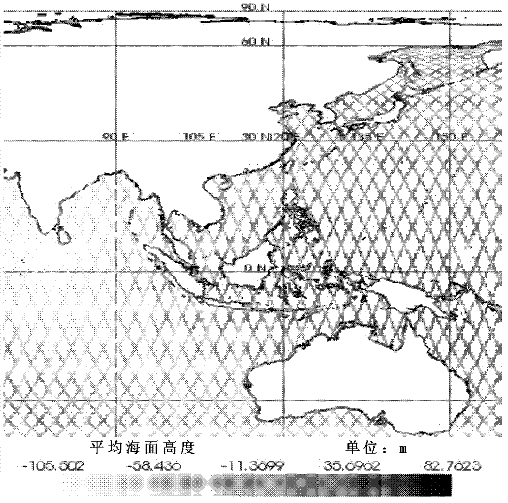
[0027] The present invention proposes a calibration field that uses the sea level covering more than two-thirds of the world, and can realize...


PUM


Abstract

The invention discloses an external calibration method of a satellite-borne interferometric synthetic aperture radar (InSAR) system. The external calibration method comprises that sea surface height data is measured by a satellite height gauge, and average sea surface height data is acquired after time varying influence factors are removed; sea surface height data measured by the satellite-borne InSAR system is acquired through sea images and uncalibrated interference parameters of preset time and space distribution acquired by the satellite-borne InSAR system; sea height variation brought about by the time varying influence factors except for the spreading effect under the condition of the preset time and space distribution is calculated in a simulation mode; time varying synthesized sea surface height data is acquired by the average sea surface height and the sea surface height variation brought about by time varying influence factors except for the spreading effect; and the sea surface height data measured by the satellite-borne InSAR system is corrected by taking the time varying synthesized sea surface height data as standard data, thereby realizing calibration of the satellite-borne InSAR system. According to the invention, an external calibration method based on a sea field is adopted, thereby being capable of carrying out long-term dynamic monitoring on slow variation elements in error of the satellite-borne InSAR system.

Description

technical field [0001] The invention relates to the technical field of radar in the electronics industry, in particular to an external calibration method for a spaceborne Interferometric Synthetic Aperture Radar (Interferometric Synthetic Aperture Radar, InSAR for short) system. Background technique [0002] The space-borne InSAR system is a technology that uses the phase information of the synthetic aperture radar to extract the three-dimensional information and elevation change information of the surface. The ground surface is obtained by simultaneous observation of two antennas or two observations of two single antennas on a satellite or space shuttle. The elevation information of the scene. With the increasing requirement of digital elevation model (Digital Elevation Model, referred to as DEM) measurement accuracy, the research on the calibration method of spaceborne InSAR system is also becoming more and more important. [0003] In InSAR, the main factors affecting DEM...

Claims


Application Information

Patent Timeline
Patent Type & Authority Patents(China)
IPC IPC(8): G01S7/40
Inventor 王宇丁赤飚梁兴东
Owner INST OF ELECTRONICS CHINESE ACAD OF SCI
Why Eureka
Try Eureka