City appearance environment detection method and system based on 3D real scene data
A technology of environmental detection and data, applied in the direction of electrical digital data processing, special data processing applications, instruments, etc., can solve the problems of low efficiency of manual scoring, difficulty in achieving unified scale, large administrative costs, etc., to ensure objectivity and fairness Sexuality, cost savings, and efficiency improvements
- Summary
- Abstract
- Description
- Claims
- Application Information
AI Technical Summary
Problems solved by technology
Method used
Image
Examples
Embodiment 1
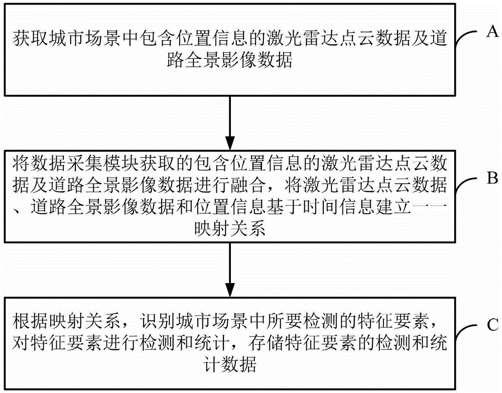
[0044] Embodiment 1 of the present invention provides a city appearance environment detection method based on three-dimensional real scene data. Such as figure 1 As shown, the method includes:
[0045] Step A: Obtain lidar point cloud data and road panorama image data containing location information in urban scenes; based on lidar point cloud data and road panorama image data, the city environment can be effectively evaluated.
[0046] Step B: Fuse the lidar point cloud data containing location information and road panoramic image data acquired by the data acquisition module, and establish a one-to-one mapping relationship based on time information for the lidar point cloud data, road panoramic image data and location information; , so that the scene in the real scene image has depth information.
[0047] Step C: According to the mapping relationship, identify the feature elements to be detected in the urban scene, detect and count the feature elements, and store the detecti...
Embodiment 2
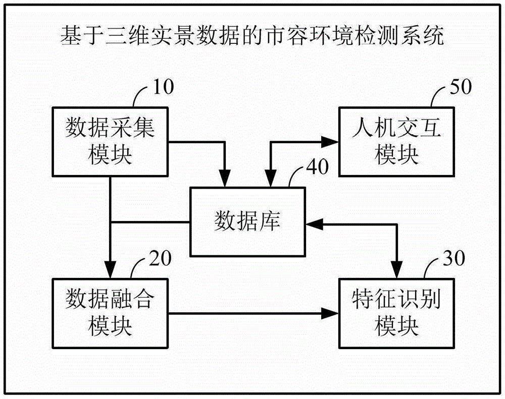
[0063] Embodiment 2 of the present invention provides a city appearance environment detection system based on three-dimensional real scene data. Such as figure 2 As shown, the system includes a data collection module 10, a data fusion module 20, a feature recognition module 30 and a database 40:
[0064] The data acquisition module 10 is used to acquire lidar point cloud data and road panorama image data including location information in urban scenes. The data collection module 40 may include a laser radar point cloud scanning device, a road panoramic image collection device and a positioning device. Among them, the lidar point cloud scanning device is used to collect laser point clouds, and the collected laser point clouds are calibrated and spliced to obtain lidar point cloud data in urban scenes; road panoramic image acquisition equipment is used to acquire road panoramic image data; the positioning device is used to obtain position information. The lidar point cloud ...
PUM
 Abstract
Description
Claims
Application Information
 - R&D
- Intellectual Property
- Life Sciences
- Materials
- Tech Scout
- Unparalleled Data Quality
- Higher Quality Content
- 60% Fewer Hallucinations
Browse by: Latest US Patents, China's latest patents, Technical Efficacy Thesaurus, Application Domain, Technology Topic, Popular Technical Reports.
© 2025 PatSnap. All rights reserved.Legal|Privacy policy|Modern Slavery Act Transparency Statement|Sitemap|About US| Contact US: help@patsnap.com


