Supercharge Your Innovation With Domain-Expert AI Agents!

Map visualization method, device and processor

A map and map data technology, applied in the field of geographic information systems, can solve problems such as separate display and high configuration

Active Publication Date: 2016-08-17
INST OF REMOTE SENSING & DIGITAL EARTH CHINESE ACADEMY OF SCI
View PDF2 Cites 0 Cited by
  • Summary
  • Abstract
  • Description
  • Claims
  • Application Information

AI Technical Summary

Problems solved by technology

[0005] In view of this, the object of the present invention is to provide a map visualization method, device and processor to solve the problem in the prior art that a higher configuration is required when using virtualization technology to realize map visualization, and to use existing Some map products, when realizing the visualization of the map, can only display the plane information of each floor separately by floor

Method used


Image

  • Map visualization method, device and processor
  • Map visualization method, device and processor
  • Map visualization method, device and processor

Examples


Embodiment Construction

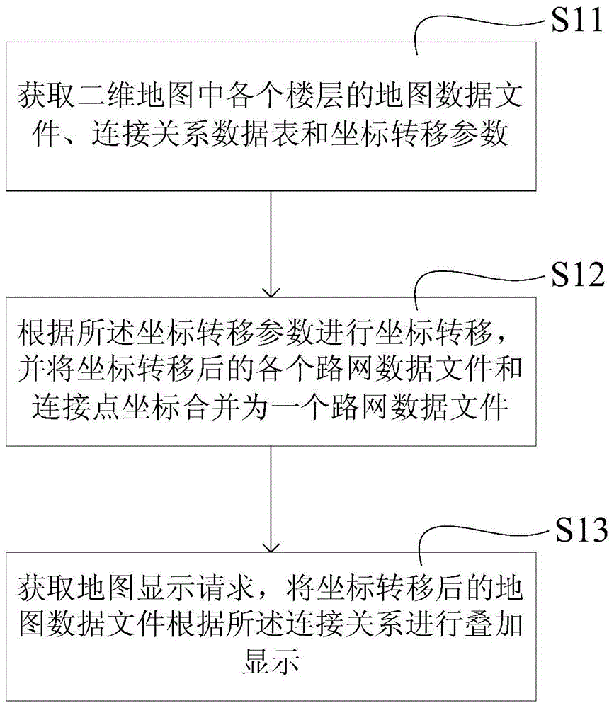
[0046] The following will clearly and completely describe the technical solutions in the embodiments of the present invention with reference to the accompanying drawings in the embodiments of the present invention. Obviously, the described embodiments are only some, not all, embodiments of the present invention. Based on the embodiments of the present invention, all other embodiments obtained by persons of ordinary skill in the art without creative efforts fall within the protection scope of the present invention.

[0047] The present application discloses a map visualization method to solve the problem in the prior art that requires higher configuration when using virtualization technology to realize map visualization, and when using existing map products to realize map visualization, It is only possible to display the plane information of each floor separately by floor. see figure 1 As shown in the schematic diagram of the workflow, the map visualization method disclosed in...


PUM


Abstract

The invention relates to the field of geographic information systems, in particular to a map visualization method and device and a processor. The method comprises the steps of acquiring a map data file, a connected relation data table and coordinate transferring parameters of each floor in a two-dimensional map, carrying out coordinate transferring on the map data files and the connected relation data tables according to the coordinate transferring parameters, acquiring the connected relation between the map data files with coordinates transferred and the floors, and executing corresponding map displaying operation after map display requests are received. According to the map visualization method, the coordinate transferring algorithm is simple, data processing speed is high, a plurality of independent plane floor map data distributed discretely can be expressed orderly in an integrated mode, information of all the floors in the whole building can be displayed integrally, the formed map data files coincide with the three-dimensional imaging rule of human eyes, the three-dimensional effect is good, and requirements for hardware configuration are low.

Description

technical field [0001] The invention relates to the field of geographic information systems, in particular to a map visualization method, device and processor. Background technique [0002] At present, in the field of GIS (Geographic Information System or Geo-Information system, geographic information system), the visual expression of maps has become a research hotspot. Visualized maps have many advantages. Among them, through visual expression of maps, the business level and management capabilities of government departments can be effectively improved. For example, when conducting fire emergency command and rescue, according to the visual expression of maps and map positioning technology, accurate Positioning, and visually displaying the positions of firefighters and trapped people, based on which an efficient rescue plan can be formulated; in addition, through visual maps, it is also conducive to further improving the ability and level of the government to serve the public...

Claims


Application Information

Patent Timeline
Patent Type & Authority Patents(China)
IPC IPC(8): G06F17/30
Inventor 杨丽娜池天河刘亚岚姚晓婧
Owner INST OF REMOTE SENSING & DIGITAL EARTH CHINESE ACADEMY OF SCI
Features
  • R&D
  • Intellectual Property
  • Life Sciences
  • Materials
  • Tech Scout
  • Unparalleled Data Quality
  • Higher Quality Content
  • 60% Fewer Hallucinations
Learn More