
Satellite capture method and device

A satellite capture and satellite technology, applied in the field of satellite navigation, can solve the problems of a large satellite capture range and cannot effectively improve the capture speed, etc., and achieve the effect of improving the satellite capture speed and reducing the capture range.

Active Publication Date: 2016-01-27
BEIJING UNIV OF POSTS & TELECOMM
View PDF4 Cites 0 Cited by
  • Summary
  • Abstract
  • Description
  • Claims
  • Application Information

AI Technical Summary

Problems solved by technology

Therefore, by predicting the Doppler frequency shift of the satellite, the range of satellite capture is narrowed, but the narrowed range of satellite capture is still very large, and it still does not effectively increase the capture speed, and there are certain limitations.

Method used


Image

  • Satellite capture method and device
  • Satellite capture method and device
  • Satellite capture method and device

Examples


Embodiment Construction

[0026] In order to make the object, technical solution and advantages of the present invention clearer, the implementation manner of the present invention will be further described in detail below in conjunction with the accompanying drawings.

[0027] GNSS navigation systems mainly include the GPS of the United States, the Beidou system of China, the Galileo system of the European Union and the GLONASS system of Russia. Among them, the space part of GPS is composed of 21 working satellites and 3 spare satellites. The 24 satellites are located in the sky above the surface of 20200km, and the operation cycle is 12h. The satellites are evenly distributed on 6 orbital planes, with 4 satellites in each orbital plane, and the orbital inclination is 55°; the space segment of the Beidou satellite navigation and positioning system consists of 5 geostationary orbit satellites, 3 inclined geosynchronous orbit satellites and several The space part of the Galileo satellite navigation syst...


PUM


Abstract

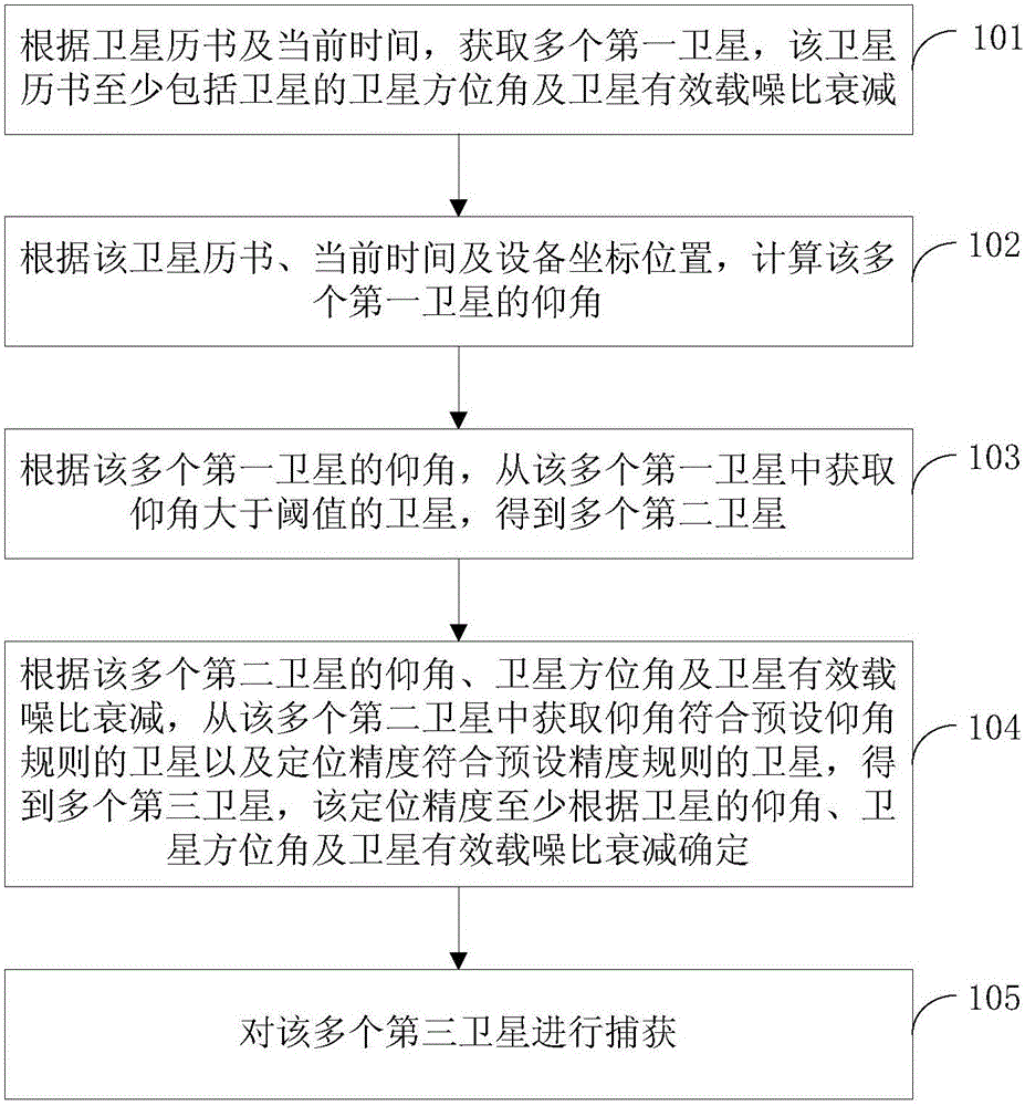
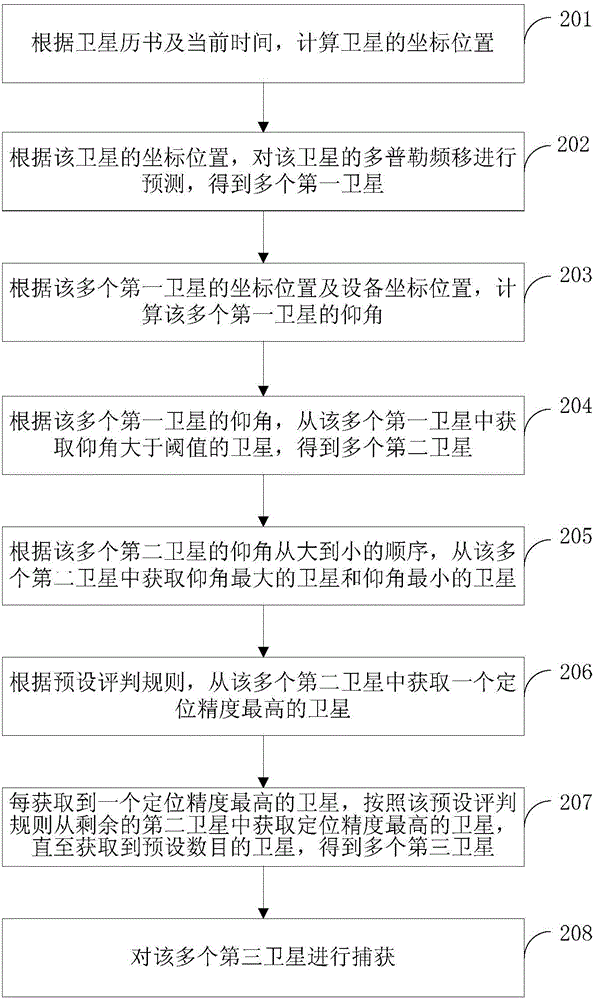
The invention discloses a satellite capturing method and a satellite capturing device and belongs to the technical field of satellite navigation. The satellite capturing method comprises the steps that multiple first satellites are obtained according to a satellite almanac and the current time; the angles of elevations of the multiple first satellites are calculated according to the satellite almanac, the current time and the coordinate positions of the equipment; satellites with the angles of elevations greater than the threshold are obtained from the multiple first satellites according to the angles of elevations of the multiple first satellites, and multiple second satellites are obtained; satellites with the angles of elevations in accordance with a preset elevation angle rule and positioning accuracy in accordance with the preset accuracy rule are obtained from the multiple second satellites according to the angles of elevations, the satellite azimuth angles and the satellite effective carrier-to-noise ratio attenuation of the multiple second satellites, and multiple third satellites are obtained; the multiple third satellites are captured. According to the satellite capturing method and the satellite capturing device, on the basis of optimum satellites, the search satellites are further optimized according to the preset elevation angle rule and the preset accuracy rule, so that the satellite capturing range is further shortened, and the satellite capturing speed is greatly improved.

Description

technical field [0001] The invention relates to the technical field of satellite navigation, in particular to a satellite acquisition method and device. Background technique [0002] GNSS (Global Navigation Satellite System, Global Navigation Satellite System) refers to all satellite navigation systems. The GNSS includes the GPS (Global Positioning System) of the United States, the GLONASS system of Russia, the Beidou system of China, the Galileo system of the European Union, etc., and the number of available satellites reaches more than 100. With the research and development of satellite navigation systems in more and more countries, how to quickly capture, track and finally achieve precise positioning of many visible satellites has become a research hotspot in the field of satellite navigation technology. [0003] In order to achieve fast satellite capture, first read the latest satellite almanac, calculate the visible satellite position, predict the Doppler frequency shi...

Claims


Application Information

Patent Timeline
Patent Type & Authority Patents(China)
IPC IPC(8): G01S19/28
CPCG01S19/28
Inventor 邓中亮董慧尹露
Owner BEIJING UNIV OF POSTS & TELECOMM
Learn More