Elevation inversion method for geosynchronous orbit synthetic aperture radar interference

A technology of synthetic aperture radar and geosynchronous orbit, which is applied in the direction of radio wave reflection/re-radiation, re-radiation, and measurement devices, and can solve problems such as interference model failure, target scene elevation error, and large difference

Active Publication Date: 2014-01-29
BEIJING INSTITUTE OF TECHNOLOGYGY +1
View PDF0 Cites 20 Cited by
  • Summary
  • Abstract
  • Description
  • Claims
  • Application Information

AI Technical Summary

Problems solved by technology

This separation will lead to serious failure of the traditional low-orbit elevation inversion interference model (sometimes the difference can be 10 times); at the same time, because GEO interferometry has the characteristics of large-scene interference processing, but for the target points on the edge of the large scene, the low-orbit elevation is used When the inversion interference model is processed, the calculated fuzzy height will also differ greatly from the real value, which will lead to a multi-period target scene with an elevation error of tens of meters or even hundreds of meters.
Therefore, the core problem of GEO SAR interferometric processing is how to solve the problem of separating the effective phase vector from the imaging plane and achieve better accuracy, which is not mentioned in the existing GEO SAR interferometric processing algorithms

Method used


Image

  • Elevation inversion method for geosynchronous orbit synthetic aperture radar interference
  • Elevation inversion method for geosynchronous orbit synthetic aperture radar interference
  • Elevation inversion method for geosynchronous orbit synthetic aperture radar interference

Examples


Embodiment Construction

[0047] Combine below Figure 1 to Figure 10 The present invention is discussed in detail. The elevation inversion method of geosynchronous orbit synthetic aperture radar interference of the present invention specifically comprises the following steps:

[0048] Step 1, select the orbit where GEO SAR acquires the interference data, and collect the interference data on the orbit.

[0049]Considering that the present invention uses interferometric processing to perform elevation inversion, it is necessary to use SAR image data acquired by GEO satellites for processing in a suitable orbit. Therefore, before the present invention carries out height inversion in GEO SAR interference model, first carry out the selection of GEO SAR acquisition interference data track, concrete method is as follows:

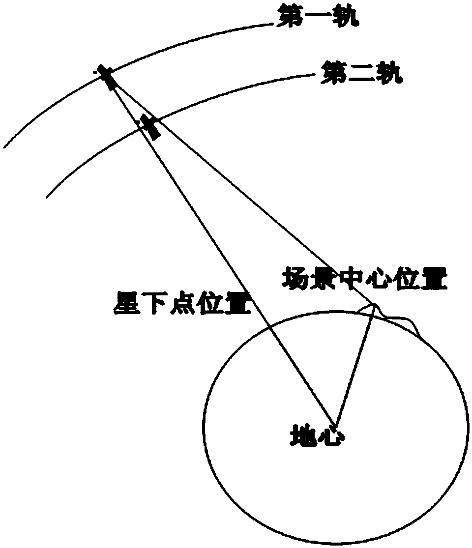
[0050] like figure 1 As shown in , first select the aperture center position of the first track according to the requirements, determine the latitude and longitude of the ground point c...


PUM


Abstract

The invention provides an elevation inversion method for geosynchronous orbit synthetic aperture radar interference. The method comprises the steps that step 1, GEO SAR is selected to obtain a track of interference data, and the interference data on the track are collected; step 2, GEO SAR imaging processing is conducted through a BP algorithm according to the interference data obtained in step 1; step 3, a GEO interference model is built according to the GEO SAR image processed in step 2, and when a phase position vector is separated from an imaging plane, the GEO SAR interference elevation inversion is conducted according to the GEO interference model. According to the elevation inversion method for the geosynchronous orbit synthetic aperture radar interference, due to the fact that the reasonable GEO SAR interference model is built, the effective elevation inversion processing under the condition that the phase position vector and the imaging plane are separated is achieved, the core problem of the elevation inversion of the GEO SAR interference processing, namely, the separation problem of the effective phase position vector and the imaging plane is solved, and the elevation inversion of the GEO SAR interference processing at any position is achieved.

Description

technical field [0001] The invention belongs to the technical field of synthetic aperture radar, in particular to an elevation inversion method for geosynchronous orbit synthetic aperture radar interference. Background technique [0002] Synthetic Aperture Radar (SAR) is an all-weather, all-time high-resolution microwave remote sensing imaging radar that can be installed on aircraft, satellites, missiles and other flying platforms. Since its invention in the 1950s, it has been widely used in many fields, such as disaster control, vegetation analysis, microwave remote sensing and other fields. Geosynchronous Orbit Synthetic Aperture Radar (GEO SAR) is a SAR satellite operating on a geosynchronous elliptical orbit at a height of 36000km. Compared with low-orbit SAR (LEO SAR, the orbit height is lower than 1000Km), GEO SAR has the characteristics of large imaging range, short revisit time, and strong anti-strike and anti-destruction capabilities. It has become a research hotsp...

Claims


Application Information

Patent Timeline
Patent Type & Authority Applications(China)
IPC IPC(8): G01S13/90G01S7/41
CPCG01S7/41G01S13/9023G01S13/9058
Inventor 胡程龙腾李元昊李延曾涛丁泽刚
Owner BEIJING INSTITUTE OF TECHNOLOGYGY
Why Eureka
Try Eureka