Satellite orbit determination system inserted in mobile communication network

A mobile communication and communication network technology, applied in the field of satellite orbit determination system, can solve the problems of time synchronization between stations, uncontrollable gross errors, unsatisfactory estimation results of adaptive methods, etc., and achieve the effect of improving accuracy

Inactive Publication Date: 2014-01-29
GUANGDONG UNIV OF TECH
View PDF5 Cites 10 Cited by
  • Summary
  • Abstract
  • Description
  • Claims
  • Application Information

AI Technical Summary

Problems solved by technology

Classical Kalman can make full use of forecast information to improve the accuracy of filter estimation, but cannot control gross errors, and when the observation model contains gross errors, the estimation results of the adaptive method are not ideal
[0007] 4. Precise orbit determination of GEO and IGSO satellite inter-satellite difference: In the local orbit determination of GEO satellites, the clock error of the station receiver is difficult to solve simultaneously with the orbit, and it is usually necessary to use inter-station time synchronization or other methods to eliminate The precise orbit determination of GEO satellites can only be carried out after the clock difference, and the accuracy of the obtained orbit Z (inertial system) direction is relatively poor. A relatively large position change solves the problem that the GEO orbit determined by the orbit in some areas needs time synchronization between stations and the poor Z-direction of the orbit

Method used


Image

  • Satellite orbit determination system inserted in mobile communication network
  • Satellite orbit determination system inserted in mobile communication network
  • Satellite orbit determination system inserted in mobile communication network

Examples


Embodiment

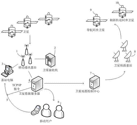
[0016] Principle of the invention figure 1 As shown, the satellite orbit determination system embedded in the mobile communication network of the present invention, the satellite orbit determination system embedded in the mobile communication network of the present invention includes several mobile communication base stations 1, satellite data servers 4, and several mobile users 6 , wherein the satellite data server 4 forwards the calculated high-precision orbital parameters to the mobile user 6, and the mobile communication base station 1 sends the collected satellite raw data to the satellite data server 4, and the satellite data server 4 transmits the calculated high-precision orbital parameters Provided to the satellite ground control center 7, the satellite ground control center 7 then uses the satellite ground station 8 to transmit the satellite orbit correction to the navigation synchronous satellite 9 and the inclined orbit synchronous satellite 10.

[0017] The above-...

Embodiment approach 1

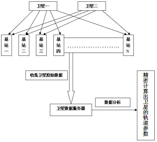
[0042] Implementation scheme 1: Use the principle of pseudo-range inter-satellite single-difference orbit determination to improve the positioning accuracy of satellite orbits.


PUM


Abstract

The invention discloses a satellite orbit determination system inserted in a mobile communication network. The satellite orbit determination system comprises a plurality of mobile communication base stations, a satellite data server and a plurality of mobile users. The satellite data server transmits calculated high-precision orbit parameters to the mobile users; the mobile communication base stations send collected original satellite data to the satellite data server; the satellite data server provides the calculated high-precision orbit parameters for a satellite ground control center; the satellite ground control center transmits satellite orbit correction to navigation geosynchronous satellites and inclined orbit geosynchronous satellites through satellite earth stations. Large-scale distributed mobile communication base stations are utilized to measure the original satellite data, and the satellite data server collects measurement data of the mobile communication base stations through networks, analyzes the measurement data, and calculates orbit parameters of the navigation geosynchronous satellites and the inclined orbit geosynchronous satellites to precisely determine satellite positions, so that the objective of improving accuracy of satellite navigation systems is achieved.

Description

technical field [0001] The invention is a satellite orbit determination system embedded in a mobile communication network, which belongs to the transformation technology of the satellite orbit determination system embedded in a mobile communication network. Background technique [0002] The space segment of China's Beidou II satellite navigation system consists of three types of satellites: Geostationary Satellites (GEO), Inclined Orbit Geostationary Satellites (IGSO) and Medium Earth Orbit Satellites (MEO). Geostationary satellites and inclined orbit synchronous satellites can provide regional factual navigation services when the number of satellites in the earth's mid-orbit is insufficient. Geostationary satellites and inclined orbits The orbits of geosynchronous satellites are about 36,000 kilometers, which is much higher than the height of 22,000 kilometers for medium-orbit earth satellites. The altitude of a geostationary satellite makes it difficult to precisely measu...

Claims


Application Information

Patent Timeline
Patent Type & Authority Applications(China)
IPC IPC(8): G01S19/12H04W84/04H04W84/06
CPCG01S19/12G01S19/44H04W84/06
Inventor 邱树泽邹俊成陈樱婷刘浩成王峰
Owner GUANGDONG UNIV OF TECH
Why Eureka
Try Eureka