Method for calculating distances between horizontal well borehole and upper and lower interfaces of stratum

A wellbore-to-horizontal well technology, applied in the direction of wellbore/well components, earthwork drilling, measurement, etc., can solve the problems that the perforation position is not optimal, and the oil recovery efficiency of horizontal wells cannot be fully improved.

Active Publication Date: 2014-02-12
PETROCHINA CO LTD
View PDF4 Cites 37 Cited by
  • Summary
  • Abstract
  • Description
  • Claims
  • Application Information

AI Technical Summary

Problems solved by technology

[0002] In the design of horizontal wells, in order to carry out well completion design or reservoir stimulation, it is necessary to determine the distance from the wellbore to the upper and lower boundaries of each formation to facilitate the design of perforation positions. The traditional method is to qualitatively estimate the wellbore through gamma and resistivity curves ( It is assumed that the wellbore runs through the sandstone) and the approximate range from the overlying or underlying mudstone, but the perforation position designed by this method is not optimal, and the oil recovery efficiency of the horizontal well cannot be fully improved

Method used


Image

  • Method for calculating distances between horizontal well borehole and upper and lower interfaces of stratum
  • Method for calculating distances between horizontal well borehole and upper and lower interfaces of stratum
  • Method for calculating distances between horizontal well borehole and upper and lower interfaces of stratum

Examples


Embodiment 1

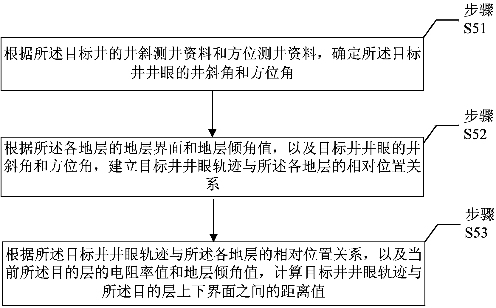
[0052] This embodiment provides a method for calculating the distance from the borehole of a horizontal well to the upper and lower boundaries of the formation, such as figure 1 As shown, the method includes:

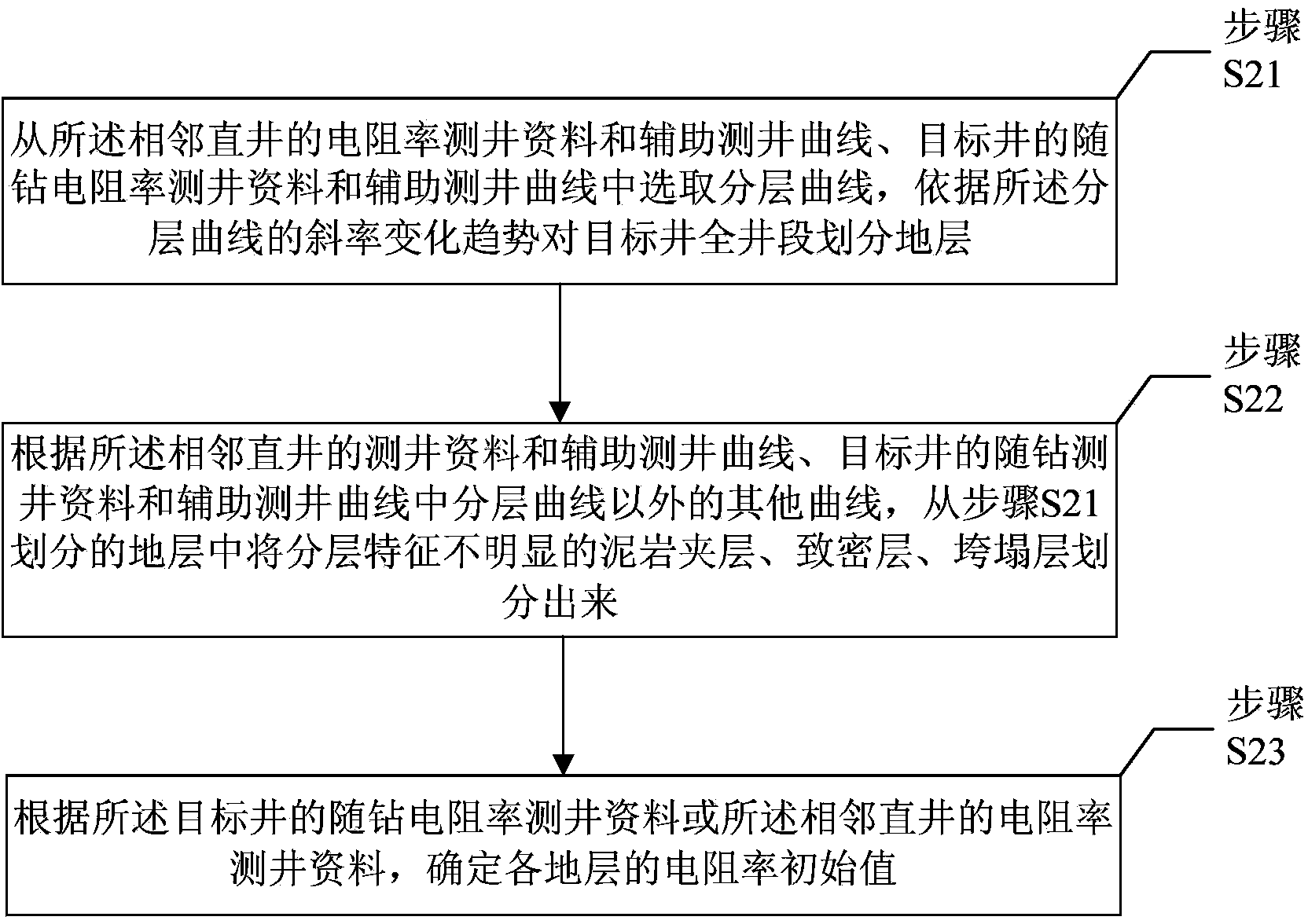
[0053] Step S1, obtaining logging data and auxiliary logging curves of adjacent vertical wells, logging-while-drilling data and auxiliary logging curves of the target well, and seismic data in the area where the target well is located; Vertical wells within the set range.

[0054] The purpose of this step is to obtain various logging data, auxiliary logging curves and seismic data, so as to provide an accurate and reliable theoretical basis for the subsequent establishment of formation models, determination of formation dips, and generation of LWD simulation response curves.

[0055] Since the pilot hole section of the target well is basically in the same formation as the adjacent vertical well, the logging data of the pilot hole section of the target well is also basi...

Embodiment 2

[0107] In this embodiment, the distance between the horizontal wellbore and the upper and lower boundaries of the formation is calculated according to the method provided in Embodiment 1 by using the resistivity logging data while drilling. Figure 6 A diagram of the implementation results.

[0108] In this embodiment, the logging data of the resistivity logging while drilling tool commonly used in horizontal wells is selected as the processing object. Figure 6 It is divided into four quadrants. Quadrant 1 is the curve head, Quadrant 2 is the vertical projection of the curve, Quadrant 3 is the well trajectory and formation model, and Quadrant 4 is the horizontal display of the curve.

[0109] In quadrant four:

[0110] The first track is the natural gamma curve, and curve ① represents the natural gamma curve.

[0111] The second track is the LWD resistivity logging curve. P33H, P33L, A33H, and A33L represent the phase resistivity at a frequency of 2MHz, the phase resistivit...


PUM


Abstract

The invention discloses a method for calculating the distances between a horizontal well borehole and the upper and lower interfaces of stratum. The method comprises the following steps: dividing the stratum of the whole well section of a target well and determining the initial resistivity value of each stratum; determining the initial stratum inclination angle value of each stratum; determining the initial resistivity value and the initial stratum inclination angle value of a target layer, and determining the resistivity logging curve while drilling corresponding to the target layer; calculating the distance values between a target well borehole trajectory and the upper and lower interfaces of the target layer; generating a resistivity well logging simulated response curve while drilling of the target layer; judging whether the resistivity well logging simulated response curve while drilling of the target layer is consistent with the resistivity logging curve while drilling corresponding to the target layer, interactively inversing and modifying the stratum resistivity value and the stratum inclination angle value of the target layer, and repeating the steps until the resistivity well logging simulated response curve while drilling of the target layer is consistent with the resistivity logging curve while drilling corresponding to the target layer. By the method, the factors of geological background, oil reservoir conditions, engineering environment and the like are fully taken into consideration; calculation results are more reasonable; basis is provided for a well completion design or reservoir reconstruction; perforation horizon optimization is facilitated; an oil-gas recovery ratio is improved.

Description

technical field [0001] The invention relates to the field of petroleum well logging, in particular to a method for calculating the distance from the borehole of a horizontal well to the upper and lower boundaries of a formation. Background technique [0002] In the design of horizontal wells, in order to carry out well completion design or reservoir stimulation, it is necessary to determine the distance from the wellbore to the upper and lower boundaries of each formation to facilitate the design of perforation positions. The traditional method is to qualitatively estimate the wellbore through gamma and resistivity curves ( It is assumed that the wellbore runs through the sandstone) and the approximate range from the overlying or underlying mudstone, but the perforation position designed by this method is not optimal, and the oil recovery efficiency of the horizontal well cannot be fully improved. Contents of the invention [0003] The invention provides a method for calcu...

Claims


Application Information

Patent Timeline
Patent Type & Authority Applications(China)
IPC IPC(8): E21B47/00E21B49/00
Inventor 王昌学周灿灿胡松王环曹文杰宋连腾李长喜胡法龙秋英淑
Owner PETROCHINA CO LTD
Why Eureka
Try Eureka