Remote-sensing image multi-scale object-oriented classification method based on joint sparsity representation

A joint-sparse, object-oriented technology, applied in the field of optical remote sensing data analysis, can solve problems that affect image object interpretation, do not consider the relationship between pixel size and feature category, plot area, high spatial resolution of high-resolution remote sensing images, etc. problem, to achieve the effect of eliminating the misclassification of "salt and pepper", important academic value, and improving interpretation accuracy

Active Publication Date: 2014-02-19
WUHAN UNIV
View PDF3 Cites 16 Cited by
  • Summary
  • Abstract
  • Description
  • Claims
  • Application Information

AI Technical Summary

Problems solved by technology

[0006] This type of technology excavates the spatial information of high-resolution remote sensing images and improves the interpretation accuracy to a certain extent, but there are still the following problems: 1) The relationship between the size of the pixel and the category of objects and the area of ​​​​the plot is not considered; 2) The image internal The spectral variability produces "salt and pepper" misclassification; 3) Pixel-by-pixel processing takes time
Due to the high spatial resolution, large noise, and large scale span of high-resolution remote sensing images, the selection of a single optimal patch scale has considerable limitations, which is likely to cause over-segmentation or under-segmentation, thereby affecting the image object. Interpretation
On the other hand, manually adjusting the segmentation scale requires users to have certain professional knowledge, which intensifies the difficulty of automatic processing of object-oriented classification technology.

Method used


Image

  • Remote-sensing image multi-scale object-oriented classification method based on joint sparsity representation
  • Remote-sensing image multi-scale object-oriented classification method based on joint sparsity representation
  • Remote-sensing image multi-scale object-oriented classification method based on joint sparsity representation

Examples


Embodiment Construction

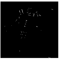
[0044] The present invention can run automatically by computer program, will combine below figure 1 And the specific steps of the method of the present invention are described in detail in the examples.

[0045] Step 1. Extract the attribute features of high spatial resolution remote sensing image data, fully mine its context, shape, texture and other image spatial information, and combine image spectral features to construct augmented features containing spatial information.

[0046] The object-oriented joint sparse expression process of the present invention is to perform joint sparse expression for augmented features including attribute features such as spectrum, context, shape, and texture, and combine each attribute feature in a vector superimposed manner, and extract each specific attribute feature for existing technology.

[0047] In this embodiment, the augmented feature of an image with a size of 400×400 is constructed, the feature dimension of the spectral attribute i...


PUM


Abstract

The invention discloses a remote-sensing image multi-scale object-oriented classification method based on joint sparsity representation. The method includes the steps of firstly, mining a spatial characteristic of a remote-sensing image and constructing an augmentation characteristic through the combination of the spatial characteristic and a spectral characteristic, secondly, constructing a redundant dictionary by means of a training pixel sample and the augmentation characteristic, carrying out joint sparsity representation on initially segmented patches by the adoption of the redundant dictionary, thirdly, carrying out homogeneity analysis and reconstruction effect analysis on the patches on the basis of the joint sparsity representation, and finally, judging whether patch segmentation is reasonable according to analysis results of the homogeneity analysis and the reconstruction effect analysis, and carrying out classification identification on the patches meeting the requirements of the homogeneity level and the reconstruction effect. The method achieves organic combination of the segmentation process and the classification process so as to obtain proper ground object patches for classification, achieves classification identification of the remote-sensing image on the object level, can obtain a classification result meeting the requirement of visual interpretation, greatly improves interpretation precision of the remote-sensing image, and has great application value.

Description

technical field [0001] The invention relates to the technical field of optical remote sensing data analysis, in particular to a multi-scale object-oriented classification method for remote sensing images based on joint sparse representation. Background technique [0002] With the rapid development of remote sensing technology, especially the launch of high spatial resolution remote sensing satellites in recent years, satellite remote sensing has been more and more applied to various fields of science and production, such as digital city construction, large-scale resource and environmental investigation, environmental monitoring , precision agriculture, archaeology and other special remote sensing monitoring. High-resolution remote sensing data itself has the following characteristics: 1) The amount of single image data has increased significantly; 2) The number of imaging spectral bands has decreased; 3) The geometric structure and texture information of ground objects are m...

Claims


Application Information

Patent Timeline
Patent Type & Authority Applications(China)
IPC IPC(8): G06T7/00
Inventor 李家艺张洪艳张良培
Owner WUHAN UNIV
Why Eureka
Try Eureka