Method for performing positioning processing on lunar exploration data by satellite

A processing method and technology for detecting data, which can be used in navigation calculation tools, integrated navigators, etc., and can solve problems such as inconsistent coordinate systems, large differences in data positioning processing and calculation models, and cumbersome integration.

Inactive Publication Date: 2014-03-19
NAT SPACE SCI CENT CAS
View PDF2 Cites 18 Cited by
  • Summary
  • Abstract
  • Description
  • Claims
  • Application Information

AI Technical Summary

Problems solved by technology

[0005] The purpose of the present invention is to address the defects of the prior art, to provide a satellite-to-the-moon detection data positioning processing method to solve the problem of large differences in data positioning processing calculation models, non-uniform coordinate systems, and integrated cumbersome and other problems, a general satellite-to-moon detection data positioning model is proposed to facilitate the integration of ground data processing software

Method used


Image

  • Method for performing positioning processing on lunar exploration data by satellite
  • Method for performing positioning processing on lunar exploration data by satellite
  • Method for performing positioning processing on lunar exploration data by satellite

Examples


Embodiment Construction

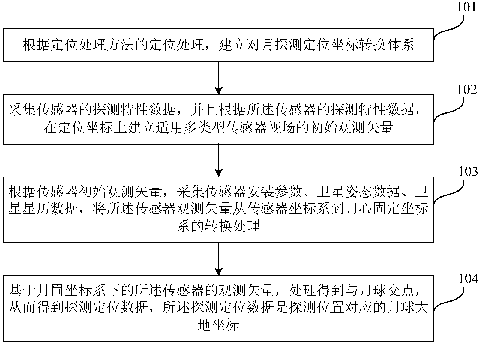
[0023] The technical solutions of the present invention will be further described in detail below through the accompanying drawings and embodiments.

[0024] See figure 1 As shown in the flow chart of the satellite positioning and processing method for monthly sounding data of the present invention, as shown in the figure, the present invention specifically includes the following steps:

[0025] Step 101: According to the positioning processing of the positioning processing method, a coordinate conversion system for moon detection and positioning is established, that is, a conversion relationship between the moon detection and positioning coordinate system and its coordinate system.

[0026] This coordinate system will provide a coordinate reference for positioning processing. The method of the present invention mainly constructs coordinate systems such as a sensor coordinate system, a satellite body coordinate system, a satellite orbit coordinate system, a J2000 lunar center inerti...


PUM


Abstract

The invention relates to a method for performing positioning processing on lunar exploration data by a satellite. The method comprises the steps of constructing a lunar exploration positioning coordinate conversion system according to positioning processing of the positioning processing method; acquiring exploration characteristic data of a sensor, and constructing initial observation vectors suitable for multiple types of sensor visual fields on positioning coordinates according to the exploration characteristic data of the sensor; acquiring sensor mounting parameters, satellite attitude data and satellite ephemeris data according to the initial observation vectors of the sensor, and converting the observation vectors of the sensor from a sensor coordinate system to a lunar center fixed coordinate system; processing the observation vectors of the server based on the lunar center fixed coordinate system to obtain an intersection between the sensor and the moon, thus obtaining exploration positioning data, wherein the exploration positioning data are lunar geodetic coordinates corresponding to an exploration position. According to the method for performing positioning processing on the lunar exploration data by the satellite, introduction of middle errors is alleviated, and the calculation precision is improved.

Description

Technical field [0001] The invention relates to the field of lunar geodesy, in particular to a method for positioning and processing satellite-to-month exploration data. Background technique [0002] Lunar exploration data is the basic data for carrying out lunar scientific inversion, research and application, and these data need to be positioned and processed before application to realize accurate lunar geo-coordinate coding of the exploration data, that is, to solve the "what" problem , First answer "where". [0003] At present, with the development of space detection technology and remote sensing technology, the satellite platform is equipped with multiple types of sensors to realize the lunar composite and three-dimensional detection [0004] For the detection data positioning and processing of multiple types of sensors in the same platform or system, the corresponding positioning model is usually studied based on the load type. Due to the difference between the research and dev...

Claims


Application Information

Patent Timeline
IPC IPC(8): G01C21/24
CPCG01C21/24G01C21/20
Inventor 李立钢
Owner NAT SPACE SCI CENT CAS
Why Eureka
Try Eureka