
Ship and port prior knowledge supported large-scale ship detection method

A priori knowledge and ship detection technology, applied in character and pattern recognition, instruments, computer components, etc., can solve problems affecting detection results, affecting the use efficiency of detection results, and insufficient information utilization

Inactive Publication Date: 2014-03-26
INST OF REMOTE SENSING & DIGITAL EARTH CHINESE ACADEMY OF SCI
View PDF3 Cites 23 Cited by
  • Summary
  • Abstract
  • Description
  • Claims
  • Application Information

AI Technical Summary

Problems solved by technology

For high-resolution images, the sea surface is complex and the image texture details are rich, and the simple threshold segmentation method is not conducive to accurate detection of ships
[0007] (2) Ships are detected only by geometric information or spectral information, and the information is not fully utilized, which may cause too many false detection results contained in the detection results, which affects the subsequent use efficiency of the detection results
[0008] (3) For the separation of ports and ships in the port area, the accuracy of the automatic algorithm separation results will directly affect the detection results; and the method with too much manual participation will affect the detection efficiency

Method used


Image

  • Ship and port prior knowledge supported large-scale ship detection method
  • Ship and port prior knowledge supported large-scale ship detection method
  • Ship and port prior knowledge supported large-scale ship detection method

Examples


Embodiment Construction

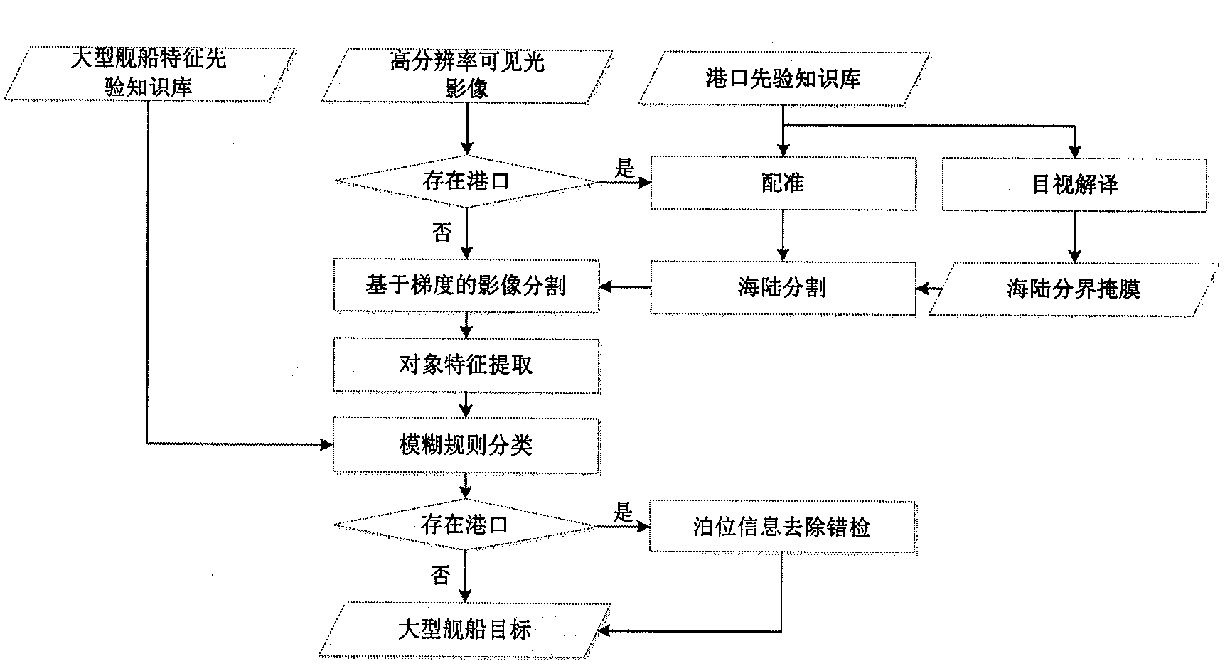
[0138] The present invention takes the fast bird image of Norfolk Harbor in the United States as an example to illustrate the specific implementation of large ship detection. The experimental images were taken on February 19, 2007, and the experimental images are as follows: figure 2 shown. The present invention will be further described below in conjunction with the accompanying drawings.

[0139] Preprocessing step S0 sea and land segmentation

[0140] Since the experimental image contains the port area and there are ships docked at the port in the image, sea and land segmentation preprocessing is required to eliminate the interference of the land part in the image and obtain sea surface images for detecting large ships.

[0141] (S01) Construct a knowledge base of sea-land segmentation of ports.

[0142] For the port to be detected, obtain the corresponding high-resolution visible light historical image, and perform geometric fine correction.

[0143] Historical images...


PUM


Abstract

The invention belongs to the technical field of remote-sensing image processing and application and relates to a method for detecting a million-ton large-scale ship target in a high-resolution multispectral remote sensing image. The method comprises the following steps: firstly, gradient-based image segmentation is carried out on an image; secondly, geometrical characteristic and color characteristic of the segmentation object are extracted; and thirdly, by the utilization of a large-scale ship characteristic prior knowledge base, the segmentation object is classified by a fuzzy rule so as to obtain a large-scale ship object. In addition, as for detection of a large-scale ship in the port area, sea and land segmentation is carried out by the utilization of sea and land boundary information in a port prior knowledge base so as to remove the influence of the land part at a port. By adding a postprocessing step, error results detected at a non-million-ton berth are eliminated by the utilization of berth information in the port prior knowledge base. By full utilization of rich spectral information and high resolution of the high-resolution multispectral remote sensing image and by the use of the prior knowledge base, high reliability of detection results is guaranteed, and manual intervention is little during the detection process.

Description

technical field [0001] The invention belongs to the technical field of remote sensing image processing and application, and relates to a method for detecting a large ship target of 10,000 tons or more in a high-resolution multispectral remote sensing image. Background technique [0002] Using remote sensing data to detect ship targets, many mature research results have been obtained using SAR data at home and abroad. However, the spatial resolution of SAR images is usually low, and the amount of information that can be further extracted from the detection results is small, making identification difficult. In addition, the preprocessing of SAR images is very complicated, which greatly affects the accuracy and efficiency of detection. [0003] With the continuous improvement of optical image resolution, the method of using high-resolution optical image for ship detection has been gradually developed. [0004] High-resolution multispectral images are usually used for ship targ...

Claims


Application Information

Patent Timeline
IPC IPC(8): G06K9/00
Inventor 汪承义孔赟珑陈静波岳安志孟瑜
Owner INST OF REMOTE SENSING & DIGITAL EARTH CHINESE ACADEMY OF SCI
Learn More