Shipborne gravity measurement method based on PPP technology

A measurement method and technology, applied in the direction of measuring devices, gravitational field measurement, geophysical measurement, etc., can solve the problems of increasing user operating costs and limited working distance, so as to improve operating efficiency, reduce operating costs, and ensure measurement accuracy Effect

Inactive Publication Date: 2014-06-11
THE CHINESE PEOPLES LIBERATION ARMY 92859 TROOPS
4 Cites 8 Cited by

AI-Extracted Technical Summary

Problems solved by technology

The application of the above method in shipborne gravity measurement has the following disadvantages: 1. At least two GPS receiv...

Abstract

The invention relates to a shipborne gravity measurement method based on the PPP technology. The method is mainly characterized in that a gravity meter and a dual-frequency GPS antenna are installed on the same straight line and used for measuring shipborne gravity, GPS observation data acquired by a measurement wire are subjected to precise single-point positioning resolving, and the accurate 3D position of an observation point is obtained; according to the accurate 3D position of the observation point, Eotvos correction and perpendicular acceleration correction are calculated; according to the gravity observation value measured by the gravity meter, the Eotvos correction and the perpendicular acceleration correction, an image-borne result gravity value is obtained through comparison calculation of base points. According to the method, only one dual-frequency GPS receiver is needed, the 3D position of a shipborne gravity measurement line can be accurately calculated through the PPP technology, and the shipborne gravity measurement can be completed without arrangement of a reference station. With the method, not only is measurement accuracy guaranteed, but also operation cost is reduced, meanwhile, region and distance limitation does not exist in the operation process, and operation efficiency is improved.

Application Domain

Satellite radio beaconingGravitational wave measurement

Technology Topic

Image

  • Shipborne gravity measurement method based on PPP technology
  • Shipborne gravity measurement method based on PPP technology
  • Shipborne gravity measurement method based on PPP technology

Examples

  • Experimental program(1)

Example Embodiment

[0018] The embodiments of the present invention will be described in further detail below with reference to the accompanying drawings.
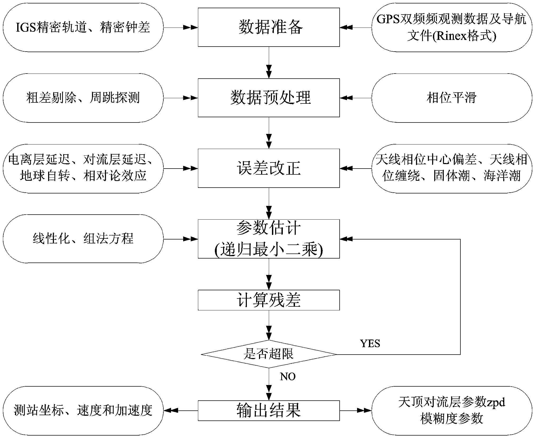
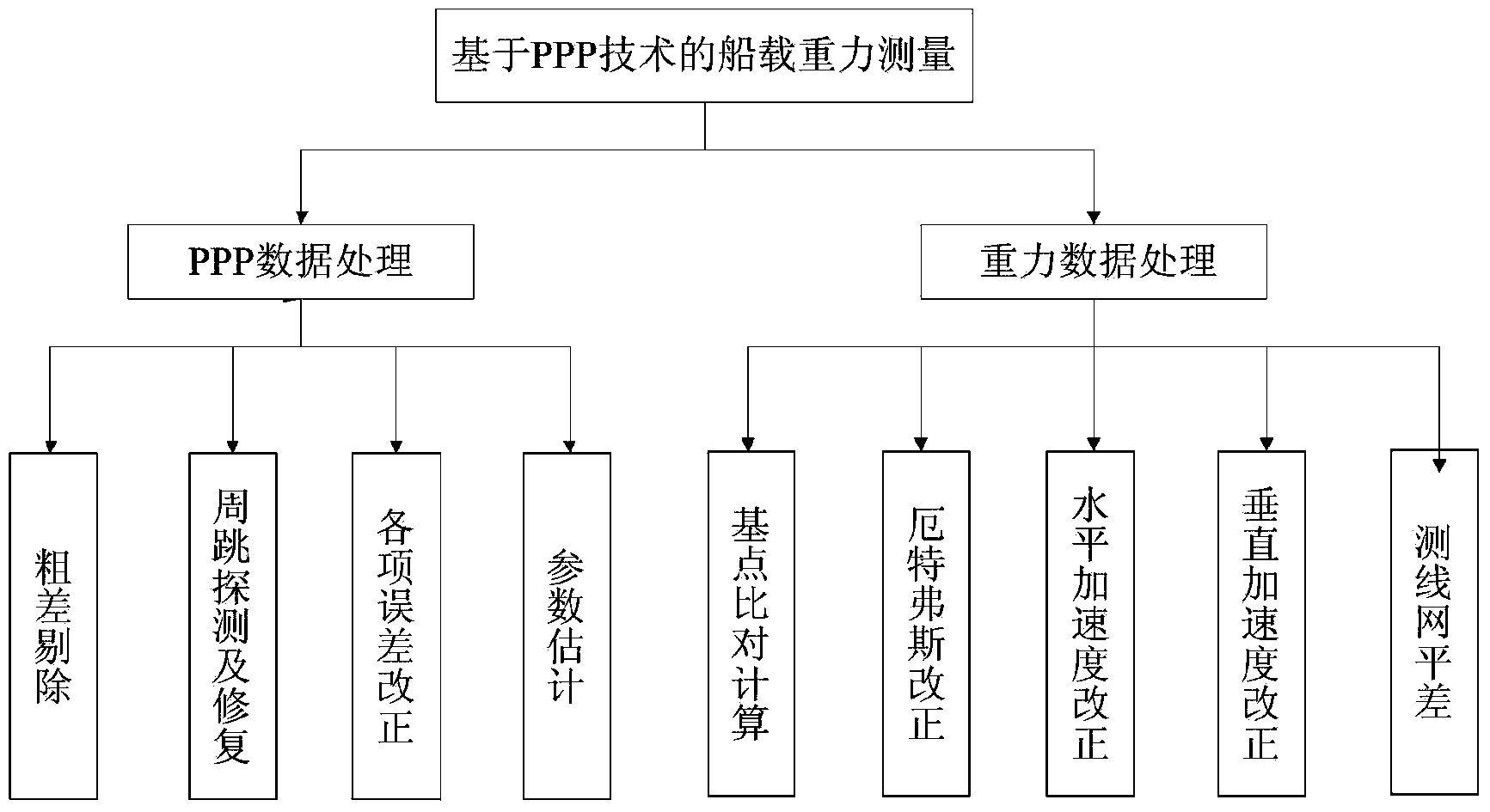
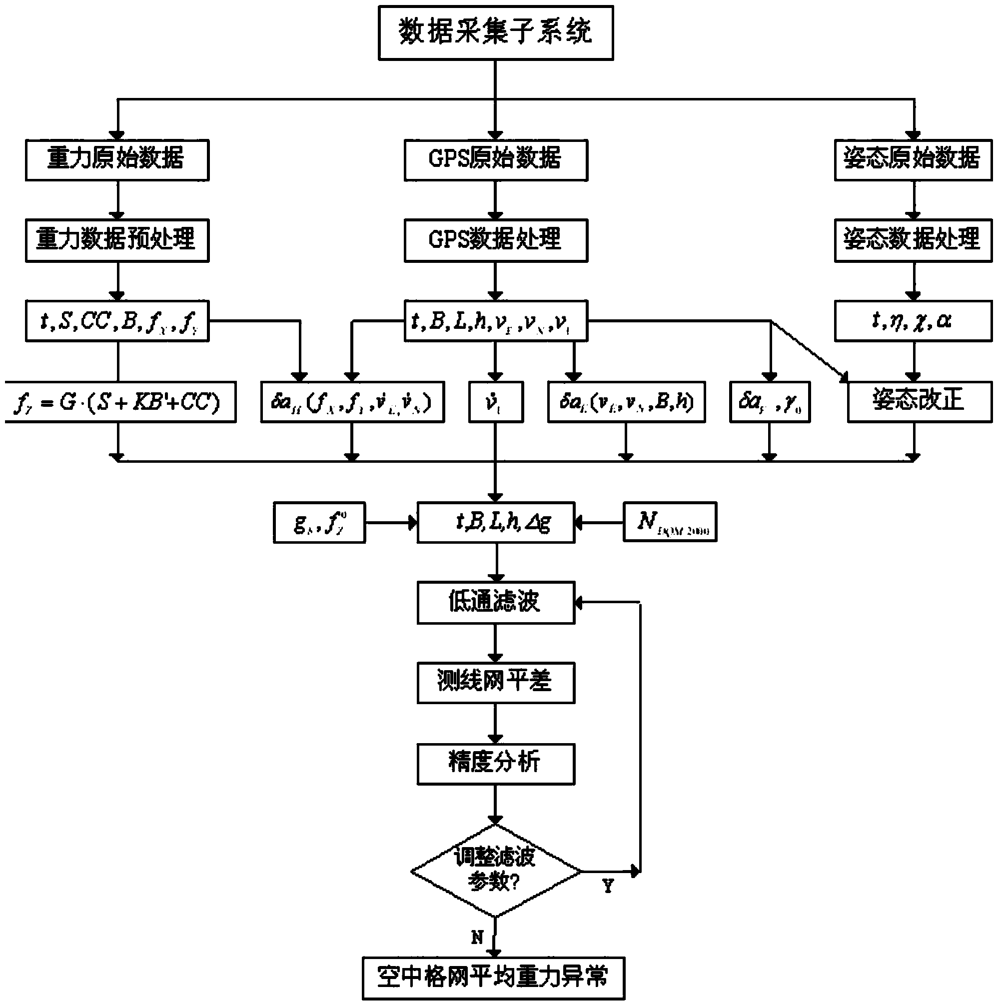
[0019] A ship-borne gravity measurement method based on PPP technology is aimed at the disadvantages of traditional ship-borne gravity measurement based on GPS differential positioning mode, and proposes the use of PPP technology (precision single-point positioning technology) for ship-borne gravity measurement operations. The main equipment installed on the berth includes GPS antenna and receiver, gravimeter, electronic compass, etc. The operation requirements are as follows:
[0020] 1. The gravimeter and dual-frequency GPS antenna are installed in a straight line. Before measuring, measure the distance from the gravimeter to the GPS antenna; if it is difficult to install the gravimeter and dual-frequency GPS antenna on a straight line, you must measure the gravimeter to the GPS The plane relative distance (dx, dy) and vertical distance of the antenna;
[0021] 2. When setting up the antenna, the height angle is greater than 15 degrees without obstruction, and it is not easy to be interfered by electromagnetic signals;
[0022] 3. When the measuring ship is stationary, adjust the installation position of the compass until the inclination reading is 0. The initial reading of the electronic compass's heading should be consistent with the compass reading on the ship or point to the bow;
[0023] 4. In order to ensure the positioning accuracy, the initial measurement time is 20 minutes, and then the formal operation.
[0024] Based on the above operation requirements, a shipborne gravity measurement method based on PPP technology proposed by the present invention includes the following steps:
[0025] Step 1: Install the dual-frequency GPS antenna and the gravimeter on the two ends of the vertical pole, carry out the ship-borne gravity measurement operation, perform precise single-point positioning calculation on the GPS observation data collected by the survey line, and obtain the accurate three-dimensional observation point position.
[0026] Obtain the survey line data observation file through the shipborne gravity measurement field, and use the downloaded precise ephemeris and precise clock error files to perform PPP calculation on the survey line data. The specific solution process is as follows figure 1 and figure 2 Shown, including sequential data preparation, data preprocessing, error improvement, parameter estimation (recursive least squares) and output results process, including data preparation. Among them, data preparation processing is to receive IGS precision orbit, precision clock offset, GPS dual-frequency observation data and navigation data and output to the data preprocessing process; data preprocessing is gross error elimination, cycle slip detection and phase smoothing processing and output to the error Correction process: The error improvement process is based on the results of data preprocessing, ionospheric delay, tropospheric delay, earth rotation, relativistic effects, antenna phase center deviation, antenna corresponding winding, solid tide, ocean tide data for error correction processing, and corrections The result is output to the parameter estimation process; the parameter estimation process is based on the error correction result, linearization, and the set of equations for parameter processing; the output result process is based on the parameter estimation result to obtain the station coordinates, speed, acceleration, zenith convection parameters, The ambiguity parameter and output the solution result, and finally get the accurate three-dimensional position of the observation point.
[0027] Step 2. Use the precise three-dimensional position of the observation point to calculate the Uttforth correction and vertical acceleration correction.
[0028] Step 3 Use the gravity observation value measured by the gravimeter and the Utfurs correction and the vertical acceleration correction, and calculate the gravity value of the results in the map by base point comparison.
[0029] Such as image 3 As shown, this step uses the data acquisition subsystem to receive the original gravity data, the original GPS issue, and the original posture data for analysis, and correct the various errors of the shipborne gravity measurement, including the use of electronic compass data for posture correction, Utforth Correction and vertical acceleration correction, and finally through the base point comparison calculation, the value of the gravimeter on the results of the map is obtained.
[0030] It should be emphasized that the embodiments described in the present invention are illustrative rather than restrictive. Therefore, the present invention includes but is not limited to the embodiments described in the specific implementation manners. Anyone skilled in the art is based on the technology of the present invention. Other implementations derived from the solution also fall within the protection scope of the present invention.

PUM

no PUM

Description & Claims & Application Information

We can also present the details of the Description, Claims and Application information to help users get a comprehensive understanding of the technical details of the patent, such as background art, summary of invention, brief description of drawings, description of embodiments, and other original content. On the other hand, users can also determine the specific scope of protection of the technology through the list of claims; as well as understand the changes in the life cycle of the technology with the presentation of the patent timeline. Login to view more.

Similar technology patents

Fault-tolerant method of redundant sensor measurement system

InactiveCN106813706AAvoid subjectivity and untimelinessGuaranteed measurement accuracyMeasurement devicesMeasurement equationsEquation of state
Owner:JIANGSU UNIV OF SCI & TECH +1

Classification and recommendation of technical efficacy words

  • Guaranteed measurement accuracy
  • Reduce operating costs

Artillery barrel bore detecting system

Owner:PEOPLES LIBERATION ARMY ORDNANCE ENG COLLEGE
Why Eureka
Try Eureka