Method and system for obtaining three-dimensional model of building

A technology of 3D models and buildings, applied in the field of photogrammetry, which can solve problems such as low automation, difficulty in establishing one-to-one correspondence between white models of buildings, and complex mapping process

Inactive Publication Date: 2014-06-25
CHINESE ACAD OF SURVEYING & MAPPING +2
View PDF2 Cites 28 Cited by
  • Summary
  • Abstract
  • Description
  • Claims
  • Application Information

AI Technical Summary

Problems solved by technology

[0005] However, the disadvantages of the existing methods for acquiring 3D models of buildings are: there is occlusion between the faces of the buildings in the acquired texture of the building, which causes the accuracy of the texture of the building to decrease, and it is difficult to establish the acquired texture. There is a one-to-one correspondence between the texture of the building and the white model of the building, but manual mapping is required, the mapping process is complex, the degree of automation is low, and the modeling cycle is long

Method used


Image

  • Method and system for obtaining three-dimensional model of building
  • Method and system for obtaining three-dimensional model of building
  • Method and system for obtaining three-dimensional model of building

Examples


Embodiment 1

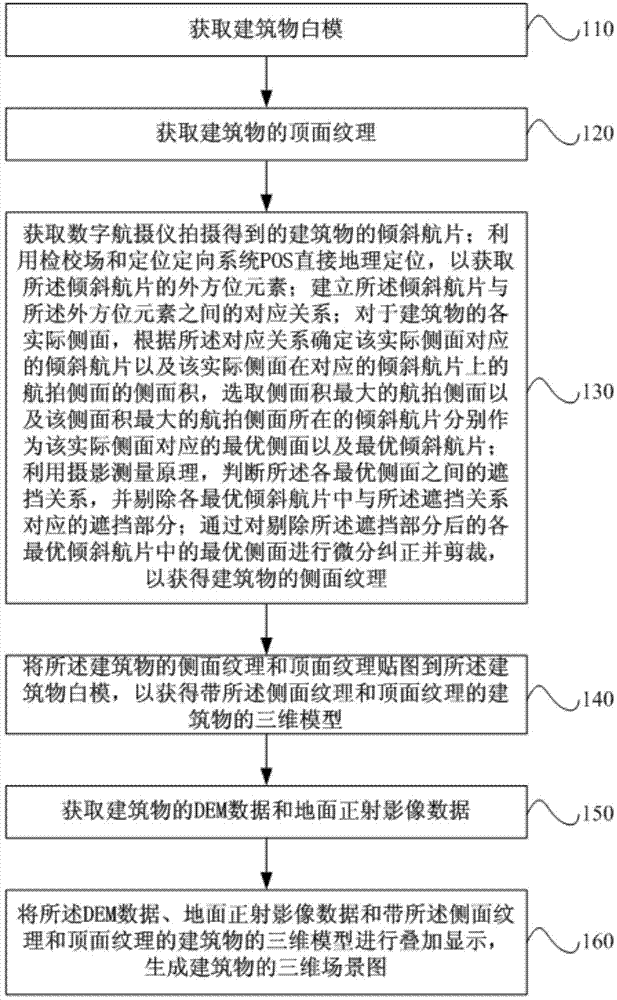
[0071] see figure 1 , a flowchart of a method for acquiring a three-dimensional model of a building provided by an embodiment of the present invention. Such as figure 1 As shown, the method may include:

[0072] Step 110, obtaining the white model of the building.

[0073] In this step, the building white model data can be determined according to the boundary vector data by acquiring the boundary vector data of the building, and then the building white model data can be obtained according to the white model data. The white mold of the acquired building can be as follows Figure 1a shown.

[0074] Step 120, acquiring the top surface texture of the building.

[0075] In this step, the top surface texture of the building can be obtained from the tilted aerial photos taken by the digital aerial camera. Preferably, it may include: obtaining the top aerial photo of the building; for each actual top surface of the building, determining the corresponding top surface according to...

Embodiment 2

[0100] see figure 2 , which is a flow chart of a method for obtaining an outer orientation element of an oblique aerial photo in a method for obtaining a three-dimensional model of a building provided by an embodiment of the present invention. On the basis of the above-mentioned embodiments, this embodiment further optimizes the acquisition method of the three-dimensional model of the building by using the calibration field and the direct geolocation of the POS to obtain the outer orientation elements of the inclined aerial photo. Such as figure 2 As shown, the method for obtaining the outer azimuth element of the inclined aerial photo may include:

[0101] Step 210, determining a first angle relationship and a first position relationship among the four tilted sub-cameras in the digital aerial camera.

[0102] The digital aerial photographing instrument integrates five cameras, and the downward-looking camera is installed vertically downward in the middle of the digital ae...

Embodiment 3

[0109] On the basis of the above-mentioned embodiments, this embodiment further optimizes the acquisition method of the three-dimensional model of the building by using the principle of photogrammetry to judge the occlusion relationship between the optimal sides. Methods for occluding relationships can include:

[0110] Step a, connecting the photographic center of the optimal tilted aerial photo where the first optimal side to be judged is located to a plurality of preset points on the first optimal side to be judged to form a plurality of preset connections;

[0111] In this step, the plurality of preset points may be each vertex of the selected polygonal surface on the first optimal side to be judged and the center point of the polygonal surface.

[0112] Step b, judging one by one whether there is an intersection between the second optimal side to be judged and the plurality of preset connecting lines;

[0113] Step c, if yes, judge whether the intersection of the second ...


PUM


Abstract

The invention provides a method and system for obtaining a three-dimensional model of a building. According to the method and system for obtaining the three-dimensional model of the building, optimal side faces and optimal oblique aerial photos which correspond to all the actual side faces of the building are selected according to exterior orientation elements of the oblique aerial photos and a method for calculating areas of oblique aerial photos, blocking parts between the optimal side faces are removed, and differential rectification and clipping are conducted on the optimal side faces, with the blocking parts being removed, in the optimal oblique aerial photos, so that the side face textures of the building are obtained and the accuracy of the side face textures of the building is improved; the one-to-one correspondence between the obtained side face textures of the building and a building blank pattern is established according to the optimal side faces, so that the textures, obtained through oblique photographing, of the building are automatically mapped to the building blank pattern, and the obtained side face textures and top surface textures of the building are mapped to the obtained building blank pattern, so that the three-dimensional model, provided with the side face textures and the top surface textures, of the building is obtained. The method and device for obtaining the three-dimensional model of the building have the advantages that the mapping processes are simplified, the automation degree is improved, and the modeling cycle is shortened.

Description

technical field [0001] Embodiments of the present invention relate to the technical field of photogrammetry, and in particular to a method and system for acquiring a three-dimensional model of a building. Background technique [0002] Digital city, also known as digital city, or smart city, refers to the comprehensive use of computer digital means to collect and process all-round digital data of urban infrastructure and functional mechanisms, with urban geography, resources, ecological environment, population, economy, and society. It is a powerful function of digitization, networking, and optimization of decision-making for complex systems, such as a technical system for rehearsing the effects of major decisions and predicting future development. City modeling is an important content and a necessary step of a digital city, and the construction of a city model is based on the construction of a three-dimensional model of a building. Therefore, a technology for obtaining a thr...

Claims


Application Information

Patent Timeline
Patent Type & Authority Applications(China)
IPC IPC(8): G06T17/00
Inventor 牛雪峰陈晓勇刘力荣杨国东郭增长左建章王双亭袁占良苏玉扬王乐洋胡倩伟
Owner CHINESE ACAD OF SURVEYING & MAPPING
Why Eureka
Try Eureka