An Urban Landscape Modeling Method Based on Color Image Recognition

A color image and modeling method technology, applied in the field of urban landscape modeling based on color image recognition, can solve problems such as urban landscape modeling, and achieve the effect of improving accuracy

Active Publication Date: 2017-01-11
WISESOFT CO LTD +1
View PDF4 Cites 0 Cited by
  • Summary
  • Abstract
  • Description
  • Claims
  • Application Information

AI Technical Summary

Problems solved by technology

[0004] The purpose of the present invention is to provide a method for modeling urban landscapes based on color image recognition, which solves the problem that the existing methods for identifying buildings cannot quickly and accurately identify and model urban landscapes in images

Method used


Image

  • An Urban Landscape Modeling Method Based on Color Image Recognition
  • An Urban Landscape Modeling Method Based on Color Image Recognition
  • An Urban Landscape Modeling Method Based on Color Image Recognition

Examples


Embodiment Construction

[0020] In order to make the object, technical solution and advantages of the present invention clearer, the present invention will be further described in detail below in conjunction with the accompanying drawings and embodiments. It should be understood that the specific embodiments described here are only used to explain the present invention, not to limit the present invention.

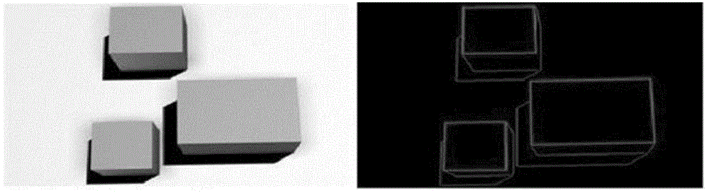
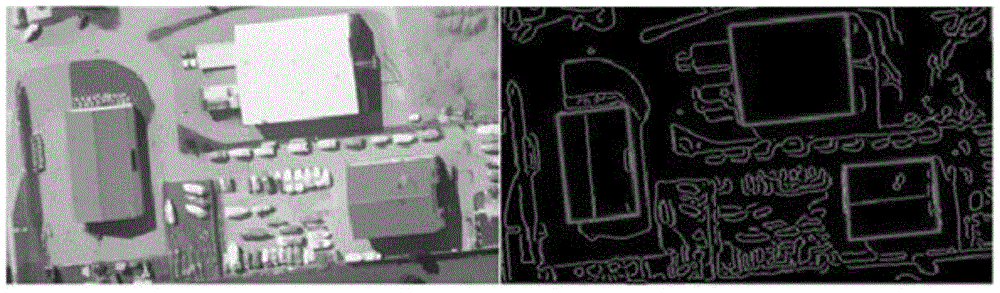
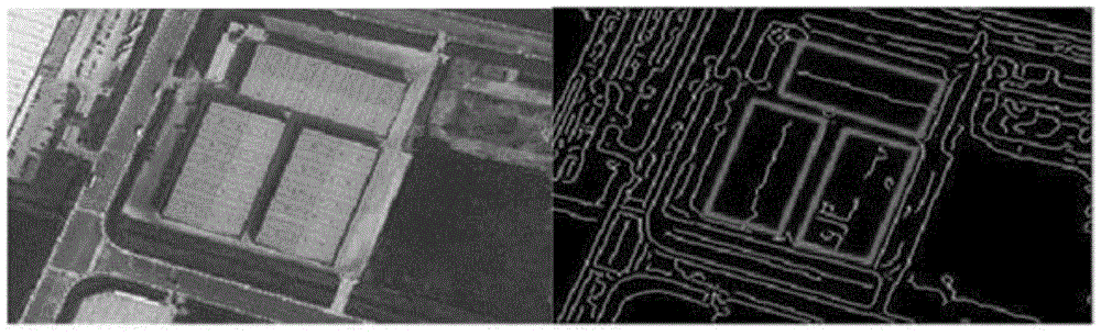
[0021] to combine figure 1 , figure 2 with image 3 It can be seen that an embodiment of a method for modeling urban landscapes based on color image recognition in the present invention: a method for modeling urban landscapes based on color image recognition, comprising the following steps:

[0022] Step 1, extract the basic straight lines that make up the roof, walls, and shadows, and form a hierarchical system (the hierarchical system is such as Figure 4 Shown), the lowest layer, namely the HO layer;

[0023] Step 2, build a bottom-up hierarchical system, and distinguish the straight lines ...


PUM


Abstract

The invention relates to an urban landscape modeling method based on colored image identification. The method comprises the steps of extracting basic straight lines constituting a roof, walls and shadows and constituting the lowest layer of the HO layer in a cast system; constructing the cast system from bottom to top, and distinguishing straight lines capable of forming a closed circuit from all the straight lines; obtaining the 3D features of a candidate roof from the straight lines capable of forming the closed circuit; quantizing the features of the candidate roof to obtain a roof model which is excellent overall. According to the method, the 2D features and 3D features of the roof and shooting angles and time are combined, and house identification accuracy is improved greatly while the height information of a building is acquired.

Description

technical field [0001] The invention relates to the fields of computer application technology and computer vision, in particular to an urban landscape modeling method based on color image recognition. Background technique [0002] Automatically identifying man-made objects in remote sensing images, such as houses, bridges, reservoirs, etc., is an important part of the field of computer vision. Among them, the identification of the building, the work that needs to be done includes the identification and reconstruction of the building. Building recognition refers to finding buildings based on simple features and photographic models; building reconstruction refers to using the geometric features of the target building, more accurate photographic models and other related data to perform high-precision reconstruction of buildings. reconstruction. [0003] Now there are many methods and algorithms for identifying buildings, which are classified according to the complexity and re...

Claims


Application Information

Patent Timeline
Patent Type & Authority Patents(China)
IPC IPC(8): G06T17/00G06T7/00
Inventor 季玉龙罗宇黄操杨善敏汪归归宋歌谭诗翰
Owner WISESOFT CO LTD
Why Eureka
Try Eureka