Constellation navigation method based on coplanar inter-satellite direction measurement and different-plane inter-satellite distance measurement

An inter-satellite ranging and navigation method technology, applied in the field of satellite autonomous navigation, can solve the problem of the slow increase of navigation error with time, and achieve the effect of high navigation accuracy

Inactive Publication Date: 2014-07-30
BEIJING INST OF CONTROL ENG
View PDF2 Cites 9 Cited by
  • Summary
  • Abstract
  • Description
  • Claims
  • Application Information

AI Technical Summary

Problems solved by technology

[0005] The problem solved by the technology of the present invention is: when performing autonomous navigation of constellation satellites based on the relative measurement information between different satellites on the same orbital plane, there is a problem that the navigation error increases slowly with time

Method used


Image

  • Constellation navigation method based on coplanar inter-satellite direction measurement and different-plane inter-satellite distance measurement
  • Constellation navigation method based on coplanar inter-satellite direction measurement and different-plane inter-satellite distance measurement
  • Constellation navigation method based on coplanar inter-satellite direction measurement and different-plane inter-satellite distance measurement

Examples


Embodiment Construction

[0040] Specific embodiments of the present invention will be further described in detail below in conjunction with the accompanying drawings.

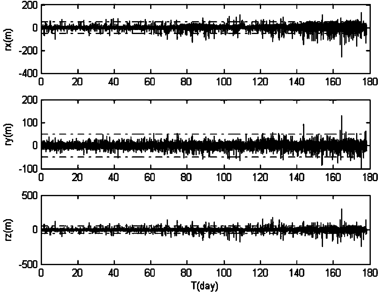
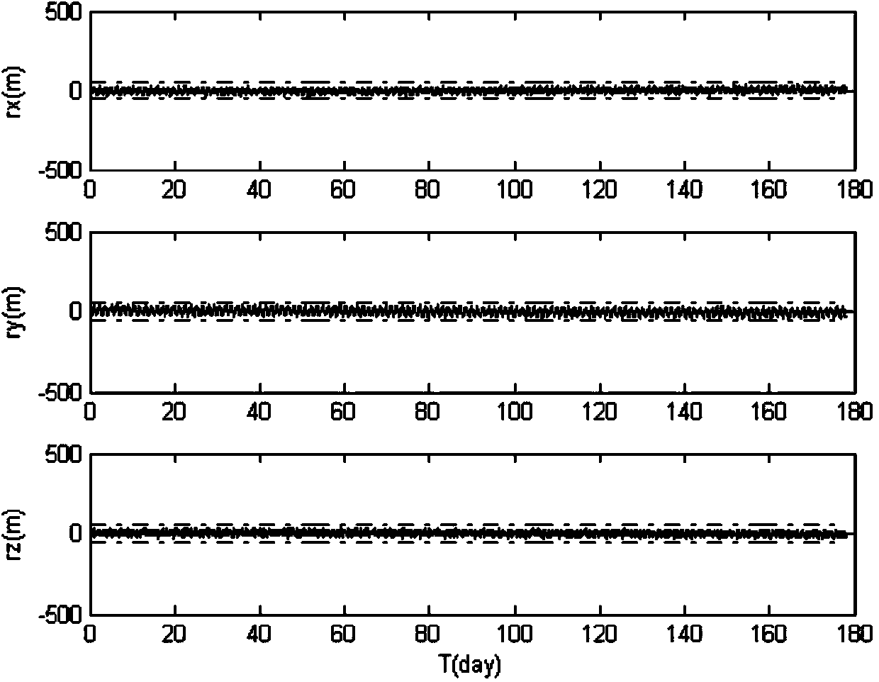
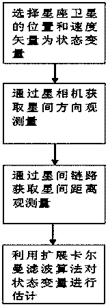
[0041] When autonomous navigation of constellation satellites is performed based on the relative measurement information between different satellites on the same orbital plane, there is a problem that the navigation error increases slowly with time. In order to solve the above problems, the present invention proposes that for a constellation composed of multiple satellites, between adjacent satellites on the same orbital plane, the inter-satellite direction measurement is carried out by means of star camera photographic observation, and the inter-satellite distance is carried out by an inter-satellite link. Measurement, at the same time, establish inter-satellite links between constellation satellites on different orbital planes to measure inter-satellite distances; use the Extended Kalman Filter (EKF) algorithm to fuse relative positio...


PUM


Abstract

The invention discloses a constellation navigation method based on coplanar inter-satellite direction measurement and different-plane inter-satellite distance measurement. The method comprises the following steps: performing inter-satellite direction measurement between adjacent satellites on the same orbit plane through a satellite camera photographic observation mode aiming at a constellation consisting of multiple satellites, performing inter-satellite distance measurement through an inter-satellite link, establishing the inter-satellite link among satellite constellations on different orbit planes, and performing inter-satellite distance measurement; fusing the measurement information of relative positions between the satellites on the same orbit plane and inter-satellite distance measurement information on different orbit planes by adopting an extended Kalman filter (EKF) algorithm, and estimating the position vectors and speed vectors of satellites taking participate in navigation by combining with an orbital dynamics equation. The method can be used for realizing a constellation satellite autonomous navigation task with high precision requirement and contributes to reducing the dependence degree of satellites on ground control and enhancing the independent survival capacity of a satellite system in the case of emergency.

Description

technical field [0001] The invention relates to a constellation navigation method based on coplanar inter-satellite direction finding and different-plane inter-satellite ranging, and belongs to the technical field of satellite autonomous navigation. Background technique [0002] Traditional satellite autonomous navigation methods include celestial navigation methods based on optical sensors and methods based on inter-satellite distance measurement, etc. Among them, astronomical navigation based on optical sensors is limited by the accuracy of geocentric direction extraction, and it is difficult to meet high-precision high-orbit satellites. Requirements for autonomous navigation; there is a "rank deficiency" problem in navigation based on the distance measurement between earth satellites, that is, the distance measurement alone cannot form effective geometric constraints on the overall rotation of the constellation, resulting in the absolute positioning error of the constellat...

Claims


Application Information

Patent Timeline
Patent Type & Authority Applications(China)
IPC IPC(8): G01C21/02
CPCG01C21/02
Inventor 熊凯魏春岭何英姿郭建新
Owner BEIJING INST OF CONTROL ENG
Why Eureka
Try Eureka