
Altitude measurement method and system

A technology of altitude and measurement method, applied in altitude/level measurement, measurement device, mapping and navigation, etc., can solve problems such as error and low accuracy

Active Publication Date: 2017-01-11
SHANGHAI PATEO ELECTRONIC EQUIPMENT MANUFACTURING CO LTD +1
View PDF5 Cites 0 Cited by
  • Summary
  • Abstract
  • Description
  • Claims
  • Application Information

AI Technical Summary

Problems solved by technology

[0005] In view of the shortcomings of the prior art described above, the purpose of the present invention is to provide a method and system for measuring altitude above sea level, which is used to solve the problem that the existing altitude measurement method has low accuracy and the error is tens to hundreds of meters

Method used


Image

  • Altitude measurement method and system
  • Altitude measurement method and system

Examples


Embodiment

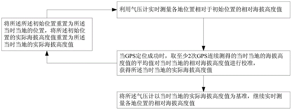
[0029] The invention provides a method for measuring altitude, such as figure 1 As shown, the altitude measurement method includes:

[0030] Use the barometer to measure the relative altitude value of each location relative to the initial location in real time. The present invention uses a barometer to obtain the relative altitude value. Although there is an error between the altitude value calculated according to the air pressure and the actual altitude, the relative altitude can be accurately calculated through the air pressure, that is, according to the air pressure values ​​at point A and point B, accurate Calculate the relative height of point A and point B.

[0031] When the GPS positioning is successful, that is, when the number of satellites received is greater than 5 and the signal-to-noise ratio is greater than 26, take the average of the local altitude values ​​measured by the GPS for at least two consecutive times to calibrate the local relative altitude values ​​...


PUM


Abstract

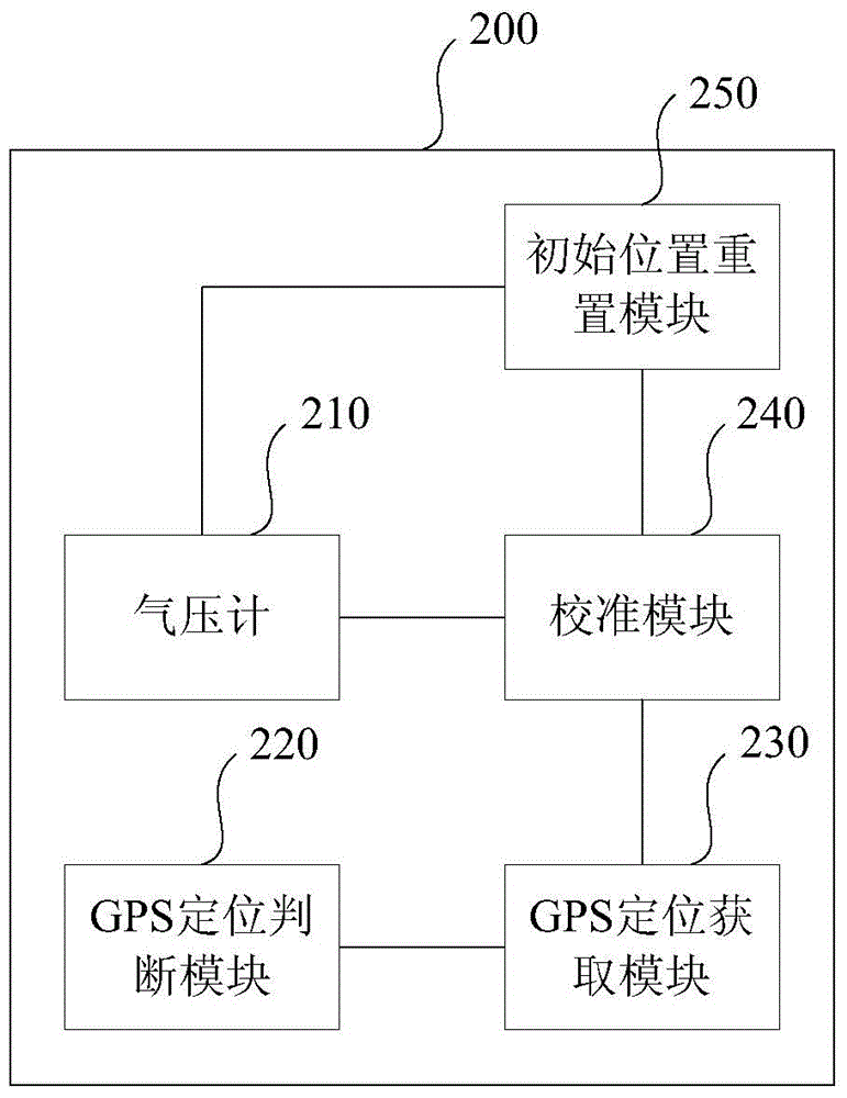
The invention provides an altitude measuring method and system. The altitude measuring method comprises the steps: measuring a relative altitude value of each position relative to an initial position in real time by using a barometer; when a GPS (Global Positioning System) is successful in positioning, namely, the number of received satellites is more than 5 and the signal to noise ratio is more than 26, averaging current and local altitudes continuously measured by the GPS at least twice to calibrate a current and local relative altitude, namely assigning the current and local relative altitude as an average value to obtain a current and local actual altitude; and with the current and local actual altitude as a datum, continuously measuring the relative altitude of each position by the barometer in real time. According to the altitude measuring method and system, the GPS and the barometer are integrated, the basic altitude is calibrated through the GPS, and the relative height is calculated by using the barometer, thus a real-time stable and accurate altitude is obtained, and an error is less than 5 m, with accuracy corrected to the meter level.

Description

technical field [0001] The invention belongs to the technical field of altitude measurement, and relates to an altitude measurement method, in particular to an altitude measurement method and system. Background technique [0002] Elevation is the vertical distance above sea level at a point on the ground. The physiological responses brought about by altitude are short-term changes, and people will gradually adapt to this high-altitude environment. [0003] Atmospheric pressure is not only related to altitude, but also to the weather. Many studies have found that the impact of atmospheric pressure on people can be summarized into three categories: one is that it increases the occurrence of diseases; the other is that seasonal changes can also affect individual psychology; the third is the impact on human behavior. In general, low atmospheric pressure is associated with high altitudes and stormy weather, while high atmospheric pressure is usually sunny. Therefore, the inter...

Claims


Application Information

Patent Timeline
Patent Type & Authority Patents(China)
IPC IPC(8): G01C5/06
CPCG01C5/06G01C25/00
Inventor 尹庆丰张胜
Owner SHANGHAI PATEO ELECTRONIC EQUIPMENT MANUFACTURING CO LTD
Learn More