Parameter-free real-time locating method based on CORS

A real-time positioning and parameter technology, applied in the field of surveying and mapping science, can solve the problems that the results cannot be directly applied, and achieve the effect of simple operation and wide applicability

Inactive Publication Date: 2014-08-27
武汉市测绘研究院
View PDF5 Cites 19 Cited by
  • Summary
  • Abstract
  • Description
  • Claims
  • Application Information

AI Technical Summary

Problems solved by technology

Because the CORS positioning result is the geocentric coordinate system, and the coordinate system used in my country's history is the paracentric coordinate system, such as the Beijing coordinate system in 1954 and the Xi'an coordinate system in 1980, although the 2000 national geodetic coordinate system (CGCS2000) that is being used is also geocentric coordinate system, but it is also different from the most widely used GPS positioning results (based on

Method used


Image

  • Parameter-free real-time locating method based on CORS

Examples


Embodiment Construction

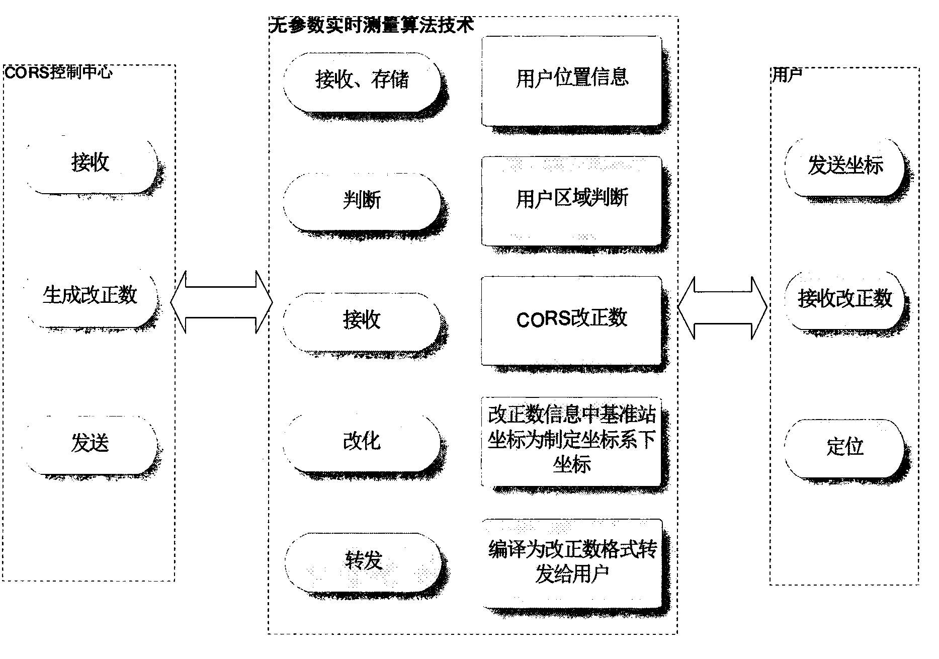
[0011] At present, the domestic CORS system generally adopts the following three methods for processing: First, it does not provide real-time positioning services based on local surveying and mapping benchmarks. Users can obtain real-time positioning results based on WGS-84, but they must be converted afterwards before they can be applied. Because this method cannot directly obtain the plane and elevation positioning results that can be directly applied, the application of the CORS system is limited. After the coordinates of the reference station are transformed into pseudo-parameters, they are re-encoded and broadcast to the user. The user end uses the pseudo-parameters corresponding to the control center to convert to obtain the plane coordinates of the urban local coordinate system. Although this method will not reveal the real conversion parameters, the real parameters can still be obtained through derivation; the third is to set the conversion parameters in the differentia...


PUM


Abstract

The invention discloses a parameter-free real-time locating method based on a CORS. The method includes the steps that summary coordinate information is sent to a control center server of the CORS and a user moving station by a user; on the basis of coordinates of a reference station, original observed values and the like, the server generates difference correcting data for the user and sends the data to the user and the user moving station; according to the summary coordinate information and the difference correcting data, the difference correcting data are converted by the user moving station through conversion parameters corresponding to the position of the user, so that converted difference correcting data are obtained and sent to the user; after receiving the converted difference correcting data, the user completes real-time locating resolution through the combination with the observed data obtained by the user, and according to corresponding projection setting, plane and elevation achievements based on a local coordinate standard are obtained.

Description

technical field [0001] The invention relates to the field of surveying and mapping science and technology, in particular to the real-time application of a GNSS continuously operating satellite positioning service system (Constinously Operating Reference Stations). Background technique [0002] With the integrated application of computer technology, communication technology, GNSS positioning technology, etc., the network RTK technology based on the continuous operation satellite reference station network can realize high-precision and high-reliability real-time positioning under long-distance conditions, so it has been widely promoted in my country use. Because the CORS positioning result is the geocentric coordinate system, and the coordinate system used in my country's history is the paracentric coordinate system, such as the Beijing coordinate system in 1954 and the Xi'an coordinate system in 1980, although the 2000 national geodetic coordinate system (CGCS2000) that is bei...

Claims


Application Information

Patent Timeline
IPC IPC(8): G01S19/45H04L9/22
CPCG01S19/41
Inventor 李江卫白洁孙伟王祥周剑
Owner 武汉市测绘研究院
Why Eureka
Try Eureka