
Multi-pixel fire point correction method for power transmission line wildfire satellite monitoring

A technology of transmission line and correction method, which is applied in the direction of electric fire alarms, etc., can solve problems such as multiple invalid fire points, and achieve the effects of avoiding alarm calculation, reducing errors and improving accuracy.

Active Publication Date: 2015-05-06
STATE GRID CORP OF CHINA +2
View PDF5 Cites 0 Cited by
  • Summary
  • Abstract
  • Description
  • Claims
  • Application Information

AI Technical Summary

Problems solved by technology

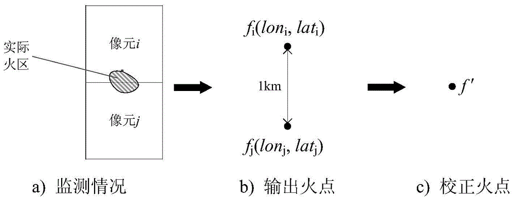
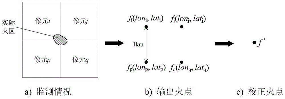
[0003] In order to solve the technical problem that a small area of ​​fire is likely to cause multiple invalid fire points in the process of mountain fire satellite monitoring of power transmission lines, the present invention proposes a highly reliable multi-pixel fire point correction method for mountain fire satellite monitoring of power transmission lines, which can avoid issuing invalid fire points Fire point warning information, and minimize the error of distance calculation

Method used


Image

  • Multi-pixel fire point correction method for power transmission line wildfire satellite monitoring
  • Multi-pixel fire point correction method for power transmission line wildfire satellite monitoring
  • Multi-pixel fire point correction method for power transmission line wildfire satellite monitoring

Examples


Embodiment Construction

[0041] The present invention will be further described below in conjunction with embodiment.

[0042] The steps of the multi-pixel fire point correction method for transmission line mountain fire satellite monitoring of the present invention are as follows:

[0043] (1), judging whether the fire point is adjacent; if the fire point data output by a single satellite monitoring system is f 1 (lon 1 ,lat 1 ), f 2 (lon 2 ,lat 2 )… f n (lon n ,lat n ), where f 1 ~ f n Monitor the fire point for the 1st~n satellites; lon 1 ~lon n are the fire point f 1 ~ f n Longitude coordinates, lat 1 ~lat n are the fire point f 1 ~ f n The latitude coordinates of , the steps to calculate whether the fire points are laterally adjacent are as follows:

[0044] (1.1) Calculate lon 1 ~lon n Pairwise difference, set the array D={∣lon 1 -lon 2 ∣,∣lon 1 -lon 3 ∣,…,∣lon 1 -lon n ∣;∣lon 2 -lon 3 ∣,∣lon 2 -lon 4 ∣,…,∣lon 2 -lon n ∣;…;∣lon n-1 -lon n ∣} means to lon 1 ~lon...


PUM


Abstract

The invention discloses a multi-pixel fire point correction method for power transmission line wildfire satellite monitoring and the method includes the following steps: finding out transversely adjacent or longitudinally adjacent pixel fire points in pixel fire point data output by a satellite monitoring system; and using two-pixel, four-pixel, six-pixel fire points or a method of combining all the fire points to correct data of the transversely adjacent or longitudinally adjacent pixel fire points so that corrected pixel fire points are obtained. The method removes a plurality of invalid fire points output by the system so that accuracy of early-warning information is improved, unnecessary warming calculation is prevented, calculation speed is improved and error of warning distance calculation is reduced to the maximum range.

Description

technical field [0001] The invention belongs to the technical field of disaster prevention and reduction for power transmission lines in electric power systems, and in particular relates to a multi-pixel fire point correction method for mountain fire satellite monitoring of power transmission lines. Background technique [0002] Wildfires near transmission lines seriously endanger the safe operation of the power grid. The use of satellite remote sensing to monitor fire points near transmission lines can quickly calculate the alarm information of wild fires on transmission lines, and can provide guidance on the prevention and control measures of on-site fires in the first place, effectively reducing tripping accidents on transmission lines caused by wildfires. The resolution of satellite data received by the existing transmission line mountain fire monitoring system is about 1.1km, but its sensitivity is relatively high. When a small-area mountain fire is at the junction of m...

Claims


Application Information

Patent Timeline
Patent Type & Authority Patents(China)
IPC IPC(8): G08B17/06
Inventor 陆佳政刘毓李波张红先方针吴传平蒋正龙
Owner STATE GRID CORP OF CHINA
Learn More