
Electronic map detail perfection control system based on unmanned aerial vehicles

An electronic map and control system technology, applied in the field of drone aerial photography, can solve the problems of inconsistencies in the electronic map, and achieve the effect of perfect details, guarantee of thoroughness, and guarantee of authenticity

Inactive Publication Date: 2014-11-05
恒创数字科技(江苏)有限公司
View PDF6 Cites 11 Cited by
  • Summary
  • Abstract
  • Description
  • Claims
  • Application Information

AI Technical Summary

Problems solved by technology

However, for the details of the local map, the electronic map is still different from the actual situation

Method used


Image

  • Electronic map detail perfection control system based on unmanned aerial vehicles
  • Electronic map detail perfection control system based on unmanned aerial vehicles

Examples


Embodiment Construction

[0017] The present invention will be further explained below in conjunction with the accompanying drawings and specific embodiments. It should be understood that the following specific embodiments are only used to illustrate the present invention and are not intended to limit the scope of the present invention.

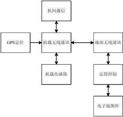
[0018] see figure 1 , the present invention relates to a UAV-based control system for perfecting electronic map details, including airborne subsystems and

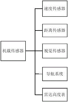
[0019] The ground subsystem, the airborne subsystem includes a GPS positioning module, an airborne wireless communication module and an airborne sensor, the airborne sensor and the GPS positioning module are respectively connected to the airborne wireless communication module, and the ground The subsystem includes a ground wireless communication system, an electronic map library, and an operation control module. The airborne wireless communication module establishes a communication connection with the ground wirel...


PUM


Abstract

The invention relates to an electronic map detail perfection control system based on unmanned aerial vehicles. Communication of airborne subsystems and a ground subsystem is established, detection information of airborne sensors and GPS positioning information are effectively transmitted to a ground operation control unit to be recognized and analyzed, and feedback information of the ground subsystem is fed back to the airborne subsystems in time to be executed and adjusted; information needing to be detected can be effectively collected and commands sent by the operation control unit can be executed in time through the airborne sensors; unification of the multiple unmanned aerial vehicles is conducted through inter-vehicle communication modules, required information is further comprehensively collected, the detection range is further expanded, and truth and thoroughness of the information are guaranteed.

Description

technical field [0001] The invention relates to the field of drone aerial photography, in particular to a drone-based control system for perfecting electronic map details. Background technique [0002] At present, the production of electronic maps mostly relies on the images taken by satellites, which can obtain relatively detailed landforms and ground building identification. However, for the details of the local map, the electronic map is still different from the actual situation. In some special occasions, more detailed map information is required, such as information on non-landmark buildings, rocks, plant coverage, etc., or ground condition exploration at the photography base. At this time, it is necessary to improve the details of the electronic map. To achieve this function, it is a good choice to use drones because of its flexibility and controllability. Contents of the invention [0003] The technical problem to be solved by the present invention is to provide ...

Claims


Application Information

Patent Timeline
IPC IPC(8): G05D1/10G01C11/00
Inventor 赵雪凤李小俊
Owner 恒创数字科技(江苏)有限公司
Features
  • Generate Ideas
  • Intellectual Property
  • Life Sciences
  • Materials
  • Tech Scout
  • Unparalleled Data Quality
  • Higher Quality Content
  • 60% Fewer Hallucinations
Learn More