
Correction method and system of environmental load of GPS (global positioning system) coordinate time series

A technology of coordinate time series and environment, applied in satellite radio beacon positioning systems, radio wave measurement systems, instruments, etc., can solve the problems of distortion of conversion parameters, wrong motion trends, GPS coordinate time series not representing reference stations, etc. Reliable position and velocity, reducing the effect of frame distortion

Active Publication Date: 2014-12-10
WUHAN UNIV
View PDF0 Cites 15 Cited by
  • Summary
  • Abstract
  • Description
  • Claims
  • Application Information

AI Technical Summary

Problems solved by technology

Freymueller (2009) found that ignoring the periodic changes of the frame points during the datum transformation will lead to the distortion of the transformation parameters and penetrate into the coordinate time series of all datum stations to cause wrong motion trends
Therefore, the GPS coordinate time series used to implement environmental load correction under the CF framework may not represent the real motion of the reference station, and the resulting environmental load correction effect may also be inaccurate

Method used


Image

  • Correction method and system of environmental load of GPS (global positioning system) coordinate time series
  • Correction method and system of environmental load of GPS (global positioning system) coordinate time series
  • Correction method and system of environmental load of GPS (global positioning system) coordinate time series

Examples


Embodiment Construction

[0039] The technical solutions of the present invention will be further described below in conjunction with the drawings and specific embodiments.

[0040] The technical solutions of the present invention will be further described below in conjunction with the drawings and specific embodiments.

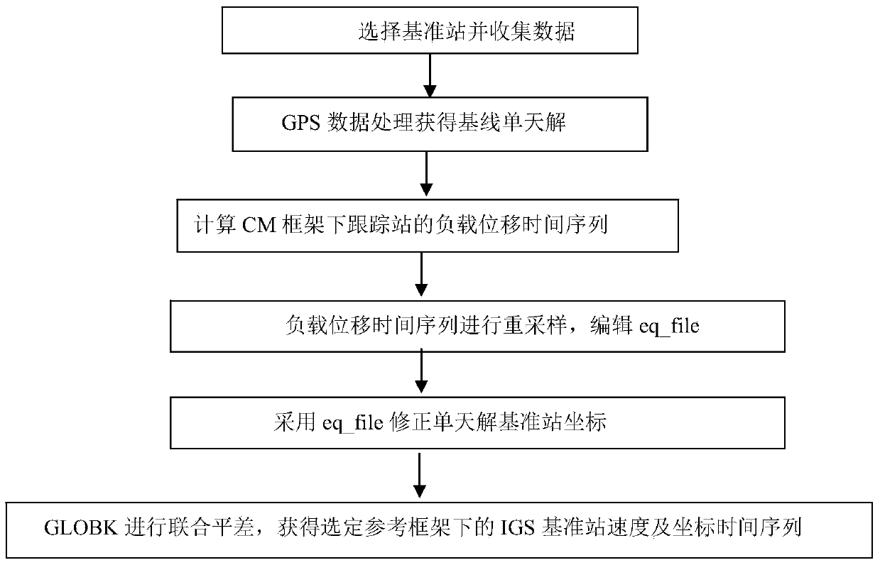
[0041] See figure 1 , the specific steps of the GPS coordinate time series environmental load correction method of the present invention are as follows:

[0042] Step 1. Obtain the observation data of the IGS reference station, and process the observation data based on the optimal data processing model to obtain the baseline single-day solution corresponding to the IGS reference station.

[0043] On the basis of the traditional data processing model, the optimal data processing model adopted in the present invention takes into account the influence of atmospheric tides, high-order ionosphere and sub-component ocean tides neglected by the traditional data processing models, so as to w...


PUM


Abstract

The invention discloses a correction method and system of environmental load of a GPS (global positioning system) coordinate time series. The method includes the steps of 1, acquiring observation data of IGS (international GPS service) reference stations, and processing the observation data by an optimal data processing model to obtain a reference line one-day solution of each IGS reference station; 2, according to the theory of elastic deformation of earth, acquiring an environmental load displacement time series of each IGS reference station under a CM (center of mass) frame; 3, correcting reference station coordinates of the reference line one-day solutions through the environmental load displacement time series of the IGS reference stations; 4, subjecting the corrected reference line one-day solutions to combined adjustment by Kalman filtering to obtain velocity and coordinate time series of the IGS reference stations. The correction method and system has the advantages that actually running GPS coordinate time series of the reference stations can be better indicated, and more reliable reference station positions and velocities can be obtained.

Description

technical field [0001] The invention belongs to the technical field of satellite navigation positioning and application, and in particular relates to a GPS coordinate time series environmental load correction method and system. Background technique [0002] The time series of GPS coordinates can not only reflect the linear changes of the reference station, but also reflect the nonlinear changes of the reference station. Many research results have confirmed the strong correlation between the surface displacement caused by environmental load and the nonlinear change of GPS reference station (van Dam and Herring, 1994; van Dam et al., 1994; van Dam et al., 1997; Zerbini et al. ., 2001; van Dam et al., 2001; Scherneck et al., 2003; Schuh et al., 2004; Petrov and Boy, 2004; Tregoning et al., 2009; van Dam et al., 2010; Tesmer et al ., 2011; Lavall'ee et al., 2010; Jiang et al., 2013). Studying the environmental load correction of GPS coordinate time series can not only obtain t...

Claims


Application Information

Patent Timeline
Patent Type & Authority Applications(China)
IPC IPC(8): G01S19/37
CPCG01S19/37
Inventor 姜卫平李昭周晓慧马一方
Owner WUHAN UNIV
Learn More