Earth face evapotranspiration remote sensing inversion method and system based on MODIS data

A technology for remote sensing inversion and evapotranspiration, which is applied in electrical digital data processing, special data processing applications, measurement devices, etc., and can solve problems such as difficult application, limited application of one-source model, and difficulty in obtaining ground meteorological and vegetation data. Achieve the effect of reducing uncertainty and broad application prospects

Inactive Publication Date: 2014-05-21
INST OF GEOGRAPHICAL SCI & NATURAL RESOURCE RES CAS
View PDF5 Cites 51 Cited by
  • Summary
  • Abstract
  • Description
  • Claims
  • Application Information

AI Technical Summary

Problems solved by technology

Clearly, this correction for aerodynamic impedance cannot be performed in all cases, severely limiting the application of the one-source model
In addition, sensor calibration, atmospheric correction, and the determination of surface emissivity will all have a fatal impact on the one-source energy balance estimation method that relies on absolute surface temperature or surface temperature difference
While one-source surface energy balance models can provide reliable estimates of surface sensible and latent heat fluxes, they generally require field corrections, making them difficult to apply to widely varying underlying surface conditions
[0005] Although the two-source energy balance model has certain advantages over the one-source ene...

Method used


Image

  • Earth face evapotranspiration remote sensing inversion method and system based on MODIS data
  • Earth face evapotranspiration remote sensing inversion method and system based on MODIS data
  • Earth face evapotranspiration remote sensing inversion method and system based on MODIS data

Examples


Embodiment Construction

[0110] The principles and features of the present invention are described below in conjunction with the accompanying drawings, and the examples given are only used to explain the present invention, and are not intended to limit the scope of the present invention.

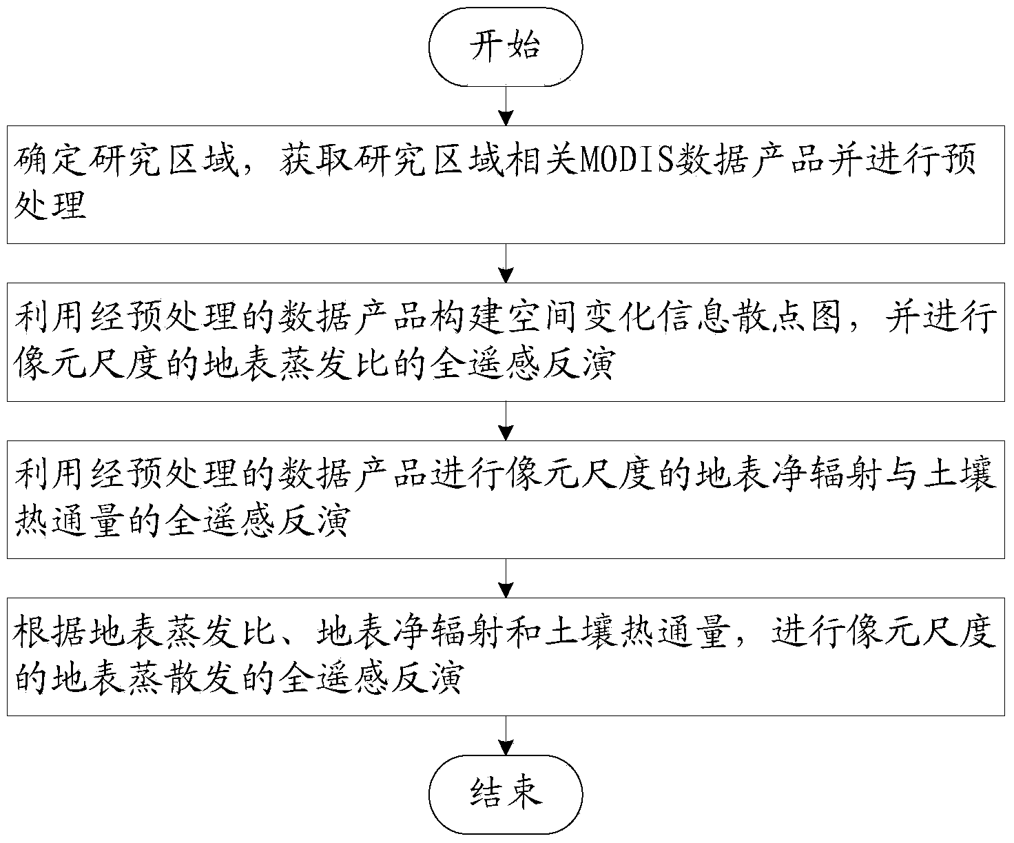
[0111] like figure 1 As shown, a full remote sensing inversion method of surface evapotranspiration based on MODIS data includes the following steps:

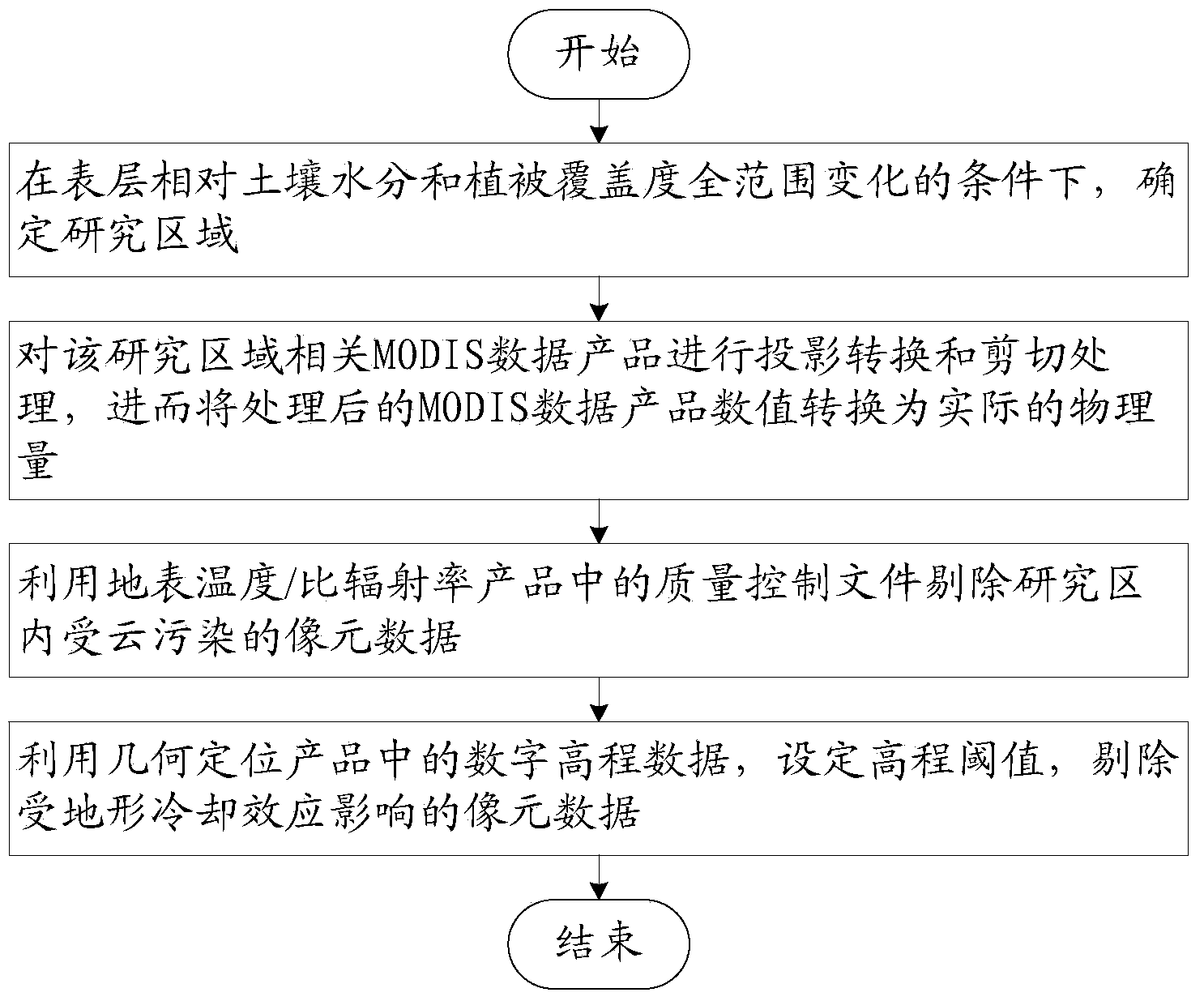
[0112] Step 1: Determine the research area, obtain MODIS data products related to the research area and perform preprocessing;

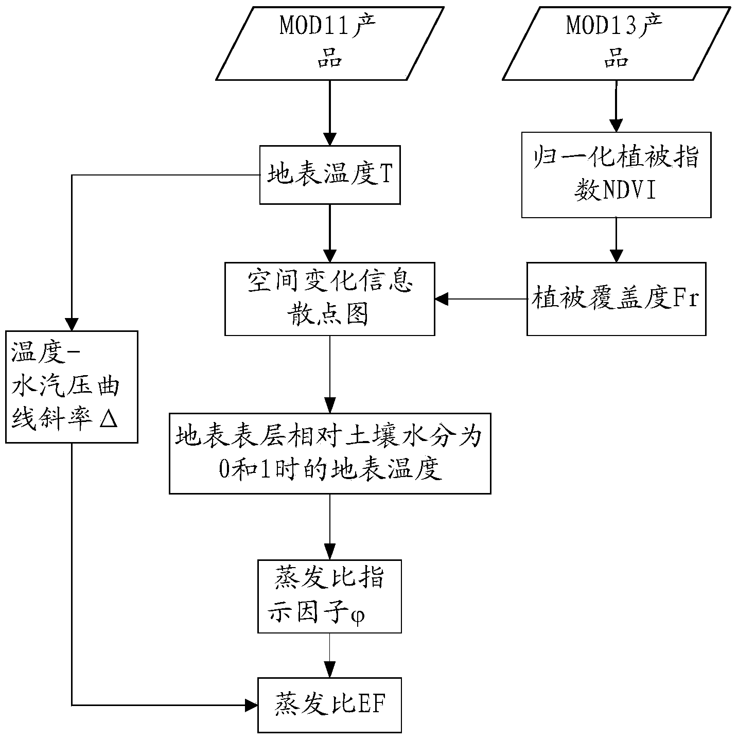
[0113] Step 2: Use the preprocessed MODIS data products to construct a scatter diagram of spatial change information, and perform full remote sensing inversion of the pixel-scale surface evaporation ratio EF;

[0114] Step 3: Use the preprocessed MODIS data products to calculate the surface net radiation R at the pixel scale n Full remote sensing inversion with soil heat flux G;

[0115] Step 4: According to the surface evaporation ratio...


PUM


Abstract

The invention relates to an earth face evapotranspiration remote sensing inversion method and system based on MODIS data. The earth face evapotranspiration remote sensing inversion method comprises the following steps that (1), a research area is confirmed, relative MODIS data porducts in the research area are achieved and pretreated; (2), a scatter diagram of space change information is built by the utilization of the pretreated MODIS data products, a remote sensing inversion of pixel sized surface evaporation ratio EF is conducted; (3), according to the relative MODIS data products, remote sensing inversions of pixel sized surface net radiation Rn and soil heat flux G are conducted; (4), according to the surface evaporation ratio EF, the surface net radiation Rn and the soil heat flux G, a remote sensing inversion of pixel sized earth face evapotranspiration LE is conducted. The earth face evapotranspiration remote sensing inversion method only needs to input the MODIS data, the problem that the current evapotranspiration remote sensing inversion usually needs more ground observation data to assist is solved, and the earth face evapotranspiration remote sensing inversion method can be used for the evapotranspiration remote sensing inversion in the area with no data or with few data.

Description

technical field [0001] The invention relates to a surface evapotranspiration inversion method and system, in particular to a surface evapotranspiration full remote sensing inversion method and system based on MODIS data. Background technique [0002] Land surface evapotranspiration is an important part of the surface energy balance and water balance, and directly affects the water and heat transfer in the soil-vegetation-atmosphere system. In research fields such as agronomy, hydrology, meteorology, etc., such as farmland irrigation and farming system management at the field scale, surface water and groundwater prediction and estimation at the regional scale, atmospheric circulation and climate change simulation at the global scale, etc., evapotranspiration plays an important role. plays an important role. The solution to almost all water problems is inseparable from the study of evapotranspiration. [0003] Traditional evapotranspiration estimation methods are mostly base...

Claims


Application Information

Patent Timeline
IPC IPC(8): G06F19/00G01N21/17
Inventor 唐荣林李召良唐伯惠吴骅
Owner INST OF GEOGRAPHICAL SCI & NATURAL RESOURCE RES CAS
Why Eureka
Try Eureka