
Vehicle real scene navigation system and method

A technology of car navigation and navigation system, applied in the field of intelligent car navigation, can solve the problems of no lane prompt, weak sense of reality, insufficient accurate navigation, etc., and achieve the effect of reducing detours and reducing driving intensity

Inactive Publication Date: 2015-01-07
GUANGDONG COAGENT ELECTRONICS SCI & TECH
View PDF13 Cites 52 Cited by
  • Summary
  • Abstract
  • Description
  • Claims
  • Application Information

AI Technical Summary

Problems solved by technology

[0007] The purpose of the present invention is to provide a vehicle-mounted real-scene navigation system and method, aiming at solving the problem that the current vehicle-mounted navigation two-dimensional plane map has a weak sense of reality, cannot well prompt the viaduct exit, and the electronic map prompts "to the right" or "to the left". "The lane change is not accurate enough, the two-dimensional plane map does not have specific lane prompts, and the navigation method is not accurate enough to reach the destination at multiple forks.

Method used


Image

  • Vehicle real scene navigation system and method
  • Vehicle real scene navigation system and method
  • Vehicle real scene navigation system and method

Examples


Embodiment Construction

[0037] In order to make the object, technical solution and advantages of the present invention more clear and definite, the present invention will be further described in detail below with reference to the accompanying drawings and examples.

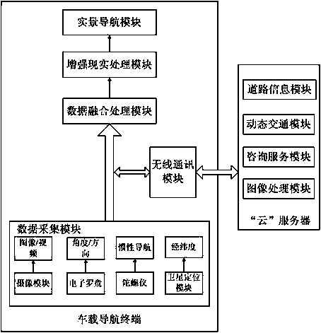
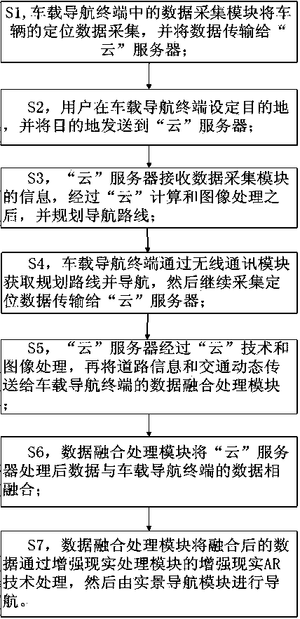
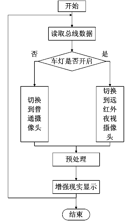
[0038] Such as figure 1 As shown, the present invention provides a vehicle-mounted real-scene navigation system, which includes: a vehicle-mounted navigation terminal for collecting image / positioning data information, and the vehicle-mounted navigation terminal also includes: a data collection module, a data fusion processing module, and an augmented reality processing module module and the real-scene navigation module, the above-mentioned modules are connected in sequence; the "cloud" server is used to receive the information of the image and position data of the vehicle navigation terminal, and return the image information and position information processed by the "cloud" technology to the vehicle navigation Terminal, the "cloud" serve...


PUM


Abstract

The invention discloses a vehicle real scene navigation system and method. The system comprises a vehicle navigation terminal and a 'cloud' server, wherein the vehicle navigation terminal is used for acquiring the information of image / position data; the vehicle navigation terminal also comprises a data acquisition module, a data fusion processing module connected with the data acquisition module, an augmented reality processing module connected with the data fusion processing module, and a real scene navigation module connected with the augmented reality processing module; the 'cloud' server is used for receiving the information of image and position data of the vehicle navigation terminal and returning the image information and the position information which are processed by a 'cloud' technology to the vehicle navigation terminal; the 'cloud' server is in two-way connection with a wireless communication module; the wireless communication module is respectively connected with the data acquisition module and the data fusion processing module.

Description

technical field [0001] The invention relates to the field of intelligent vehicle navigation, in particular to a vehicle real-scene navigation system and method applying technologies such as augmented reality, "cloud" computing service, image recognition processing and far-infrared sensing. Background technique [0002] The application of car navigation has been widely recognized. Electronic map navigation and voice prompts have become necessary tools for driving to a new place. However, the current navigation methods and technologies still have some shortcomings in practical applications: the current electronic map It is a two-dimensional planar map, which is very different from the actual situation seen by the driver, especially in places where there are dense viaducts in provincial capitals and other cities. Obviously, car owners are more likely to miss the correct exit; in addition, due to the large number of cars in big cities, they cannot see the marking lines on the gr...

Claims


Application Information

Patent Timeline
Patent Type & Authority Applications(China)
IPC IPC(8): G01C21/26G01C21/36
CPCG01C21/26G01C21/3647
Inventor 曾昭德汤冬梅梁锦荣程国洪麦景彪
Owner GUANGDONG COAGENT ELECTRONICS SCI & TECH
Learn More