Composite big-data GIS (geographic information system) based abnormal behavior analysis and alarm system

It is a technology of behavior analysis and alarm system, which is applied in the fields of electronic digital data processing, structured data retrieval, geographic information database, etc., and can solve problems such as inability to correlate data

Active Publication Date: 2015-01-28
SHENZHEN INST OF ADVANCED TECH
View PDF7 Cites 12 Cited by
  • Summary
  • Abstract
  • Description
  • Claims
  • Application Information

AI Technical Summary

Problems solved by technology

[0004] The present invention aims to overcome the technical defects of relying on manual analysis and not being able to correlate various types of data when positioning and tracking existing multi-dimensional data dimensions, and provides an abnormal behavior analysis and alarm system based on composite big data GIS

Method used


Image

  • Composite big-data GIS (geographic information system) based abnormal behavior analysis and alarm system
  • Composite big-data GIS (geographic information system) based abnormal behavior analysis and alarm system

Examples


Embodiment Construction

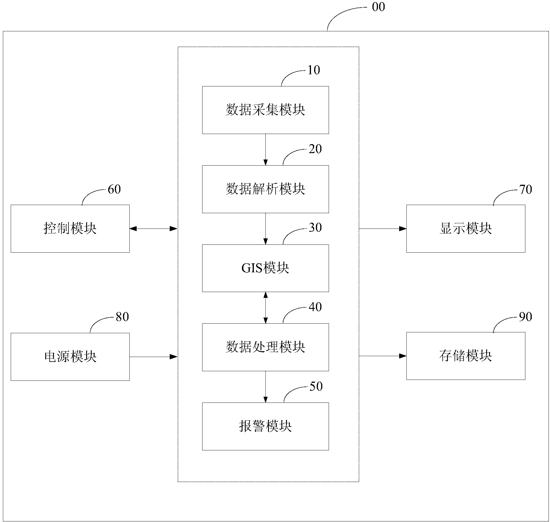
[0030] In order to make the object, technical solution and advantages of the present invention clearer, the present invention will be further described in detail below in conjunction with the accompanying drawings and specific embodiments. It should be understood that the specific embodiments described here are only used to explain the present invention, but not to limit the present invention.
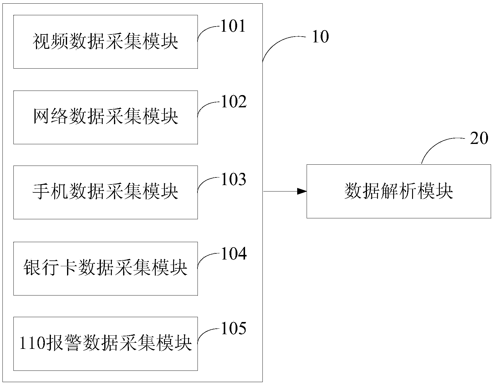
[0031] The idea of ​​the present invention is: on the basis of unifying the space-time coordinate system with GIS (Geographic Information System), through the big data association fusion with the space coordinate as the link. Enable multi-source data to perform compound search, spatial overlay and cluster analysis based on spatial location, thereby upgrading the manual correlation comparison of two-dimensional crime data to automatic correlation analysis of multi-dimensional crime data. Specifically, according to the characteristic identity information of key groups (name, image, addre...


PUM


Abstract

The invention relates to the field of city security management, in particular to a composite big-data GIS (geographic information system) based abnormal behavior analysis and alarm system. The system comprises a video, a network, a mobile phone and a bank card which are in real-time access to coordinates and a data acquisition module, a data analysis module, a GIS module, a data processing module and an alarm module of 110 alarm data; the data acquisition module transmits the data to the data analysis module, the data analysis module is connected with the GIS module, the data processing module is in mutual communication with the GIS module, the data processing module performs analysis on the data and transmits data related information to the GIS module, and the GIS module generates a dynamic distribution map of the multidimensional data according to the data related information; the alarm module receives information of the data processing module and outputs alarm signals. The video, the network, the mobile phone and the bank card are effectively combined with the 110 alarm data, criminal behaviors are analyzed, tracked and positioned by the aid of the GIS electronic map displaying dynamic distribution of the multidimensional data, and the effect that the criminal behaviors are monitored is finally achieved.

Description

technical field [0001] The invention relates to the technical field of urban safety management, in particular to an abnormal behavior analysis and alarm system based on composite big data GIS. Background technique [0002] At present, with the development of urban management technology, there are more and more means to obtain urban monitoring data. Therefore, there is a large amount of mobile data in the city management and operation system, such as mobile phones, videos, networks, bank cards, etc., which are used to track and find criminal suspects. However, at present, the correlation analysis between various data is mostly carried out manually, which is inefficient, and it is difficult to effectively integrate various systems, and it is difficult to identify and track only through a certain type of data. Therefore, there is an urgent need for a system that effectively integrates various data and performs correlation analysis to monitor and judge criminal behavior. [00...

Claims


Application Information

Patent Timeline
IPC IPC(8): G06F17/30
CPCG06F16/29
Inventor 修文群
Owner SHENZHEN INST OF ADVANCED TECH
Why Eureka
Try Eureka