
A Method of Spatial Keyword Retrieval on Road Network

A keyword and spatial index technology, applied in the field of efficient spatial keyword retrieval, can solve the problems of high time and space complexity, poor scalability, unsuitable for complex road network data, etc., and achieve the effect of improving query efficiency

Active Publication Date: 2018-09-14
神行太保智能科技(苏州)有限公司
View PDF2 Cites 0 Cited by
  • Summary
  • Abstract
  • Description
  • Claims
  • Application Information

AI Technical Summary

Problems solved by technology

However, this method and other methods have a common disadvantage, that is, they are not suitable for complex or very large road network data.
They are less scalable and have higher time and space complexity

Method used


Image

  • A Method of Spatial Keyword Retrieval on Road Network
  • A Method of Spatial Keyword Retrieval on Road Network
  • A Method of Spatial Keyword Retrieval on Road Network

Examples


Embodiment Construction

[0017] For a better understanding of the present invention, the corresponding terms are firstly described below.

[0018] 1. Road network

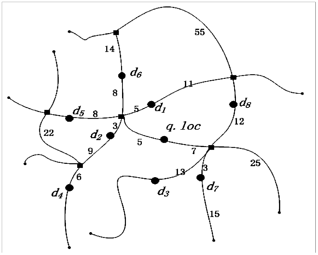
[0019] A weight map G is used here to represent the road network (ie road network). G=(V,E,W), where V represents the set of all vertices in the roadnetwork, E represents the set of all edges, and W is the set of weights of all edges in G, that is, the distance between pairs of vertices. For example, υ∈V means that υ is the intersection or end point of the edges in the road network in G. And (υ, ν) ∈ E means (υ, ν) is a certain road section in the road network, and the corresponding w υ,v Then it represents the weight corresponding to the edge (υ, ν), that is, the distance on the edge. Among them, ||υ, ν|| represents the shortest distance on the side (υ, ν), that is, ||υ, ν||=w υ,v , and the shortest distance between query q and target o is ||q,o||=min(||q,υ||+||o,υ||,||q,ν||+||o ,ν||).

[0020] 2. Graph segmentation

[0021] Given ...


PUM


Abstract

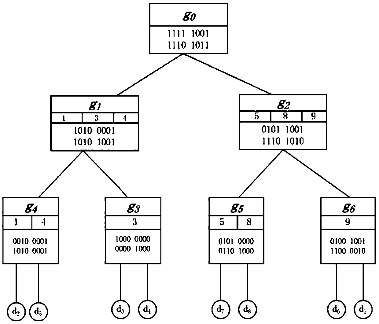
The invention discloses an efficient space keyword search method on a road network. Three methods including SNE, FITG and SG-Tree are put forward, wherein the performance of the SG-Tree method is the best, and the SG-Tree method is the main method of the road network space keyword search method. Specifically speaking, according to the SNE method, corresponding signatures are built for all edges of the road network, the Dijkstra algorithm is utilized, the network is traversed in a network expanding mode, and efficiency is low; according to the FITG method, a novel space index and a text inverted index are combined, the inquiring process is executed according to the pruning principle of text first and space second in serial, the efficiency is improved greatly, but defects still exist; thus, the space index and text index signature technology is utilized, a mixed index SG-Tree is put forward, corresponding signatures are built for all joints of a space index G-Tree, whether the joints comprise targets conforming to search or not can be efficiently detected, pruning can be carried out on two dimensions of space and text at the same time, and the search efficiency is greatly improved.

Description

technical field [0001] The invention belongs to the field of spatial text indexing, and in particular relates to a method for realizing efficient spatial keyword retrieval on a road network by using a spatial index tree. Background technique [0002] With the rapid development of spatial positioning technology, mobile devices (e.g, smartphones) are becoming more and more popular in our daily life, and location-based services are also developing rapidly, which are becoming more and more closely related to human life. In daily life, a large amount of text data with geographic location tags is generated every day through mobile devices. For example, in location-based search services (e.g, Google Maps, Yahoo! Maps etc) some target location information is provided with a short text description, and people can publish text information with geographic location through these applications, which involves to spatial keyword query techniques. [0003] Most of the current spatial keyw...

Claims


Application Information

Patent Timeline
Patent Type & Authority Patents(China)
IPC IPC(8): G06F17/30
CPCG06F16/29
Inventor 赵朋朋方海林许佳捷周晓方
Owner 神行太保智能科技(苏州)有限公司
Learn More