Road grade-based shortest route-planning algorithm

A road grade and shortest path technology, applied in the field of computer science and geographic information science, can solve problems such as unconsidered, effective algorithm, and large amount of calculation

Active Publication Date: 2015-03-11
CHINESE ACAD OF SURVEYING & MAPPING
View PDF5 Cites 12 Cited by
  • Summary
  • Abstract
  • Description
  • Claims
  • Application Information

AI Technical Summary

Problems solved by technology

Although some new algorithms have been proposed based on this, these algorithms are not very effective
For the first type of method, it is necessary to calculate the correlation between different roads constructed by road nodes, so as to perform alternative calculations. The algorithm is complex and the amount of calculation is large.
Therefore, the second type of method is more commonly used, but the existing research often only considers the weight of road nodes, but does not consider different road grades and the minimum time limit under different road grades. Therefore, a combination of road grades and road grade constraints is studied. A new algorithm for the shortest time is very necessary

Method used


Image

  • Road grade-based shortest route-planning algorithm
  • Road grade-based shortest route-planning algorithm
  • Road grade-based shortest route-planning algorithm

Examples


Embodiment Construction

[0058] In order to make the purpose, technical solution and advantages of the present invention clearer, the present invention will be further described in detail below in conjunction with the accompanying drawings and embodiments. However, the examples given are not intended to limit the present invention.

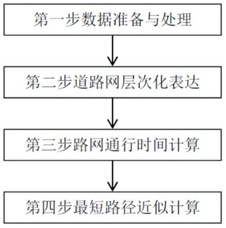
[0059] The specific implementation process of this method is as follows: figure 1 As shown, the following four steps are described, the first is data preparation and preprocessing, the second is hierarchical expression based on road grades, the third is calculating the transit time of adjacent nodes in the road network, and the fourth is approximate calculation of the shortest path.

[0060] A shortest path planning algorithm based on road grades, comprising the following steps:

[0061] Step 1, data preparation and data preprocessing,

[0062] The data preparation is to obtain road network data through GPS navigation, obtain road one-way line information data through t...


PUM


Abstract

The invention relates to a road grade-based shortest route-planning algorithm. The road grade-based shortest route-planning algorithm comprises the following steps: firstly, data preparation and data preprocessing; secondly, road network hierarchical expression, wherein road network grade division and road grade-based hierarchical expression are included; thirdly, road network passing time calculation; fourthly, shortest route approximate calculation. According to the road grade-based shortest route-planning algorithm provided by the invention, a large number of experiments prove that the passing capacity of different grades of roads are taken into full consideration; the passing time is taken as a judgment standard; a calculation method is general; the results are more precise; in emergency rescue, if a fault road section in a rod network can be excluded by road detection information, the real-time passing speed is calculated by acquiring traffic flow, and the planning result is more accurate.

Description

technical field [0001] The invention belongs to the fields of computer science and geographic information science, and relates to a shortest path planning algorithm based on road grades. Background technique [0002] The calculation of the shortest path is a classic problem. One of the most practical applications is path analysis in road networks, such as finding the best path from the starting point to the destination point in a given road network. The current shortest path analysis method can be summarized into two categories in terms of the algorithm’s realizability and stability: one is to make full use of the spatial correlation of the shortest path in the road network, and compress the shortest path in the road network into a simple format, which can greatly improve query efficiency. This method is more representative of the improved SILC (Spatially Induced Linkage Cognizance) algorithm proposed by H.Samet and J.Sankaranarayanan et al., and the PCPD (PCPD) proposed by ...

Claims


Application Information

Patent Timeline
Patent Type & Authority Applications(China)
IPC IPC(8): G01C21/20
CPCG01C21/3446
Inventor 赵阳阳张福浩石丽红仇阿根陶坤旺胡璐锦张章张卫平
Owner CHINESE ACAD OF SURVEYING & MAPPING
Why Eureka
Try Eureka